Offutt Lake, Washington | |
|---|---|
 Offutt Lake  Offutt Lake | |
| Coordinates: 46°54′37″N122°49′32″W / 46.91028°N 122.82556°W | |
| Country | United States |
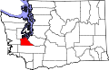
| State | Washington |
| County | Thurston |
| Time zone | UTC-8 (Pacific (PST)) |
| • Summer (DST) | UTC-7 (PDT) |
Offutt Lake is an unincorporated community in Thurston County, in the U.S. state of Washington. [1] The community is situated around Offutt Lake and is east of Millersylvania State Park. The populated area of Skookumchuck lies to the east and the city of Tenino is roughly south.