Tono, Washington

Last updated

Tono, Washington
Washington Union Coal Co, view of town of Tono (CURTIS 1140).jpeg
Tono in 1909
USA Washington location map.svg
Red pog.svg
Tono
Usa edcp location map.svg
Red pog.svg
Tono
Coordinates: 46°46′28.3″N122°49′28.3″W / 46.774528°N 122.824528°W / 46.774528; -122.824528
Country United States
State Washington
County Thurston
Founded1907
Time zone UTC-8 (Pacific (PST))
  Summer (DST) UTC-7 (PDT)

Tono is a ghost town in southwest Washington in the United States. It was a company-owned mining town founded in 1907 by the Washington Union Coal Company, a subsidiary of the Union Pacific Railroad to supply coal for their steam locomotives. Tono was located in southern Thurston County about 20 miles (32 km) south of Olympia, Washington, 5 miles (8.0 km) south of Tenino, 2 miles (3.2 km) east of the town of Bucoda, at the end of a railroad spur. [1]

Contents

History

The town was named Tono in 1909 by one of the many Japanese railroad workers. [2] Folk etymology states the name is a contraction of "ton of coal". [3]

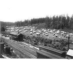
At its peak in the 1920s Tono had over 1,000 residents, 125 houses, a hotel, a hospital, a general store, and a school. The town flourished until 1932 when the railroads began switching to diesel locomotives; the Union Pacific then sold the mines to the Bucoda Mining Company. Afterwards the mines operated intermittently while most of the residents moved away. Many of the vacant houses were sold and moved to nearby communities. By 1950, there were only a few buildings and residents left in Tono. [4] The last full-time residents of Tono were John and Lempi Hirvela, who had moved there in 1923. The Hirvelas lived in the last surviving home, until 1976: The mine superintendent's former residence. [5] [4]

In 1967 the Pacific Power & Light Company revived operations at the Tono field, now known as the Centralia Coal Mine. P.P. & L. purchased the property including the town site (and the Hirvela's home) and began strip mining the area to supply coal for the Centralia Power Plant in nearby Lewis County<.ref>"Tono ghosts to get a 150,000 kW jolt". The Daily Olympian . Olympia, WA. 5 January 1967.</ref> Mining operations obliterated most of the former town site in the 1980s. All that remains of Tono are a few overgrown foundations.

Related Research Articles

<span class="mw-page-title-main">Thurston County, Washington</span> County in Washington, United States

Thurston County is a county located in the U.S. state of Washington. As of the 2020 census, its population was 294,793. The county seat and largest city is Olympia, the state capital.

<span class="mw-page-title-main">Centralia, Pennsylvania</span> Ghost town in Pennsylvania, United States

Centralia is a borough and near-ghost town in Columbia County, Pennsylvania, United States. It is part of Northeastern Pennsylvania. Its population declined from 1,000 in 1980 to five residents in 2020 because a coal mine fire has been burning beneath the borough since 1962. Centralia, part of the Bloomsburg–Berwick metropolitan area, is the least-populated municipality in Pennsylvania. It is completely surrounded by Conyngham Township.

<span class="mw-page-title-main">Ravensdale, Washington</span> Census-designated place in Washington, United States

Ravensdale is a census-designated place (CDP) in King County, Washington, United States. The population was 555 at the 2020 census.

<span class="mw-page-title-main">Centralia, Washington</span> City in Washington, United States

Centralia is a city in Lewis County, Washington, United States. It is located along Interstate 5 near the midpoint between Seattle and Portland, Oregon. The city had a population of 18,183 at the 2020 census. Centralia is twinned with Chehalis, located to the south near the confluence of the Chehalis and Newaukum rivers.

<span class="mw-page-title-main">Bucoda, Washington</span> Town in Washington, United States

Bucoda is a town in Thurston County, Washington, United States. The population was 600 at the 2020 census. The community refers to itself as the "World's Tiniest Town with the Biggest Halloween Spirit".

<span class="mw-page-title-main">Rainier, Washington</span> City in Washington, United States

Rainier is a city in Thurston County, Washington, United States. Beginning as a train stop in the 1870s, Rainier was first settled in 1890 and would become known as a logging town. The city was officially incorporated in 1947.

<span class="mw-page-title-main">Tenino, Washington</span> City in Washington, United States

Tenino is a city in Thurston County, Washington, United States. The population was 1,870 at the 2020 census.

<span class="mw-page-title-main">Skookumchuck River</span> River in Washington, United States

The Skookumchuck River is a 45-mile (72 km) long river located in southwest Washington, United States. It is a tributary of the Chehalis River and thence to the Pacific Ocean. The Skookumchuck Dam was built in 1970, creating the Skookumchuck Reservoir. The dam provides water supply for the 1400-megawatt Centralia Steam Electric Plant and supplements flows for fish resources. The river begins with several tributaries in the Snoqualmie National Forest in the foothills of the Cascade Mountains, and flows west past the town of Bucoda, Washington to its confluence with the Chehalis River near Centralia, Washington.

<span class="mw-page-title-main">Dawson, New Mexico</span> Ghost town in New Mexico, United States

Dawson is a ghost town in Colfax County, New Mexico, United States. Dawson is located approximately 17 miles northeast of Cimarron, and was the site of two separate coal mining disasters in 1913 and 1923. In 1950, the mines were closed, and by 1954 the last residents had left and the post office closed.

<span class="mw-page-title-main">Mineral, Washington</span> Census-designated place in Washington, United States

Mineral is an unincorporated community and census-designated place (CDP) in Lewis County, Washington, on State Route 7 near the Pierce/Lewis county line. Mineral originally began as a logging camp and mining town. Prospectors searching the area for gold instead found coal and arsenic. By the early 1920s, the mines closed, and with a devastating fire to the town's largest sawmill, Mineral began to turn to tourism as its main industry, primarily through recreational fishing on Mineral Lake. The population was 193 at the 2020 census, down from 202 at the 2010 census.

<span class="mw-page-title-main">Centralia Coal Mine</span> Mine in Washington (state), US

Centralia Coal Mine was an open-pit coal mine, owned by the Canadian-based TransAlta Corporation. The mine shut down in 2006. Also referred to as the TransAlta Centralia Mining (TCM) operation, the coal mine was located approximately 5 miles (8 km) northeast of the city of Centralia, in Lewis County, in the US state of Washington. Together with Centralia Power Plant, it was bought in May 2000 by TransAlta for $554 million – $101 million for the mine and $453 million for the power plant.

<span class="mw-page-title-main">Puget Sound and Pacific Railroad</span> Transport company

The Puget Sound and Pacific Railroad is a Class III shortline railroad that operates 158 miles of track serving the Kitsap Peninsula, Grays Harbor County and Centralia, Washington in the U.S. State of Washington, and is headquartered in Centralia, where the railroad interchanges with the BNSF Railway and the Union Pacific Railroad. The railroad has been a subsidiary of the Genesee and Wyoming since 2012.

<span class="mw-page-title-main">Washington State Route 507</span> State highway in Washington, United States

State Route 507 (SR 507) is a Washington state highway in Lewis, Thurston and Pierce counties that extends 43.52 miles (70.04 km) from Interstate 5 (I-5) and U.S. Route 12 (US 12) in Centralia to SR 7 in Spanaway. The highway also intersects SR 510 in Yelm and SR 702 in McKenna. The first appearance of the roadway on a map was in 1916 and since, two highways, Secondary State Highway 5H (SSH 5H) and SSH 1N, were established on the current route of SR 507 in 1937 and 1943. They both became SR 507 during the 1964 highway renumbering.

Grass Creek is a ghost town in Summit County, Utah, United States. Lying some 8 miles (13 km) northeast of Coalville, it was once an important coal mining town. Grass Creek was inhabited circa 1860–1940.

<span class="mw-page-title-main">Franklin, Washington</span> Ghost town in Washington (state)


Franklin was a coal mining town located in east King County, Washington, near the current so-called Hanging Gardens on the Green River, about 1 mile (1.6 km) east of Black Diamond.

<span class="mw-page-title-main">Fairfax, Washington</span> Ghost town in Washington (state)

Fairfax was a coal town in Pierce County in the U.S. state of Washington. The town was located on the Carbon River about 6 miles (10 km) south of Carbonado, Washington, on SR 165. Mining lasted only until the minerals ceased to be economically viable following World War I. Until the completion of the nearby 240 feet (73 m) high O'Farrell Bridge in 1921, the town was only accessible via railroad or pack train.

The Black Diamond Coal Mining Railroad was 5.9 miles (9.5 km) long and ran from Black Diamond Landing, California to Nortonville, California. It was owned and operated by the Black Diamond Coal Mining Company and therefore did not have its own official name. Over the years, it has been known by at least four different names.

<span class="mw-page-title-main">Olympia and Belmore Railroad</span>

The Olympia and Belmore Railroad is a short-line railroad headquartered in Centralia, Washington, USA. The railroad operates a line leased from the BNSF Railway which runs between Olympia and Belmore. The company began operations in 2016. It is a subsidiary of Genesee & Wyoming.

<span class="mw-page-title-main">J. J. Donovan</span> Washington State pioneer

John Joseph Donovan was a Washington State pioneer and the president of the state Chamber of Commerce, as well as one of the key founders of the City Council of Bellingham, Washington. During his life, Donovan actively participated in political, industrial, and commercial activity on city, county, and state levels. Several historic landmarks exist in Bellingham honoring J. J. Donovan, including his house, which was added to the National Historic Register, and a bronze statue installed in Fairhaven, Washington.

The Centralia Canal, also known as Centralia Power Canal, is a canal in Thurston and Pierce counties, Washington, United States. It is the only feature named a canal in Western Washington. The canal parallels the Nisqually River for 9 miles (14 km) in and around the city of Yelm. It was built in 1929 to supply water for the 12-megawatt Yelm hydroelectric project belonging to the city of Centralia's City Light Department.

References

  1. Dwelley, Arthur (14 October 1987). "Community rose and vanished on [a] bed of coal". The Daily Olympian . Olympia, WA.
  2. Ramsey, Guy Reed (1988). Postmarked Washington: Thurston County. pp. 95–96.
  3. Meany, Edmond S. (1923). Origin of Washington Geographic Names. Seattle, WA: University of Washington Press. p. 313.
  4. 1 2 Johnson, Mona (n.d.). Lempi and John Hirvela bid Tono farewell (newspaper clipping). Historic clipping file. Olympia, WA: Olympia branch, Timberland Regional Library.
  5. Johnson, Ruth (December 1976). "Tono: Coal mining Finns of Washington State". Finnish American Historical Society of the West (newsletter). Vol. 9, no. 2.