Bellingham is an area of South East London, England, within the London Borough of Lewisham. It lies south of Catford and north-west of Beckenham, and is part of the Catford postal district (SE6).
Brockley is a district and an electoral ward of south London, England, in the London Borough of Lewisham 5 miles (8 km) south-east of Charing Cross.

Crofton Park is a mainly residential suburb and electoral ward in the London Borough of Lewisham.
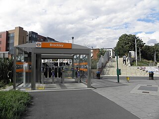
Brockley railway station serves the south-east London district of Brockley and is on the main railway line between London Bridge and Brighton. It is 3 miles 56 chains down the line from London Bridge.

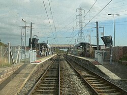
The Durham Coast Line is an approximately 39.5-mile (63.6 km) railway line running between Newcastle and Middlesbrough in North East England. Heavy rail passenger services, predominantly operated Northern Trains, and some freight services operate over the whole length of the line; it provides an important diversionary route at times when the East Coast Main Line is closed. Light rail services of the Tyne and Wear Metro's Green Line also operate over the same tracks between a junction just south of Sunderland station and Pelaw Junction.

The Leamside Line, originally part of the Durham Junction Railway, is a disused railway line, located in the North East of England. The alignment diverges from the East Coast Main Line at Tursdale Junction, travelling a distance of 21 miles north through the Durham Coalfield and Washington, prior to joining the Durham Coast Line at Pelaw Junction. The Leamside Line closed to passenger traffic in 1964, under the Beeching cuts.

Brockley Whins is a Tyne and Wear Metro station, serving the suburbs of Boldon Colliery and Brockley Whins, South Tyneside in Tyne and Wear, England. It joined the network on 31 March 2002, following the opening of the extension from Pelaw to South Hylton.

East Boldon is a Tyne and Wear Metro station, serving the villages of Cleadon and East Boldon, South Tyneside in Tyne and Wear, England. It joined the network on 31 March 2002, following the opening of the extension from Pelaw to South Hylton.
Brockley is a district of London, England.

Ladywell is a locale in Lewisham in South East London, England, and a ward in the London Borough of Lewisham between Brockley, Crofton Park and Lewisham proper. It has ample green space including Ladywell Fields and Hilly Fields which borders Brockley. Ladywell Village, the main shopping area along Ladywell Road, was given a facelift in 2013 with £800,000 of Transport for London funding. The pavements were widened, short stay bays created to help local businesses and shoppers, and trees were added. Ladywell Village has a range of retail outlets including a number of cafes, a patisserie and a delicatessen.

Brockley Hill was a proposed London Underground station in the Brockley Hill area of north London. The planned location is in what is now Edgware Way Grassland close to Edgwarebury Park on the north side of the junction of Edgware Way / Watford Bypass (A41), and Spur Road (A410).

Brockley(not to be confused with Brockley Green, 8 miles southwest in Hundon parish) is a village and civil parish in the West Suffolk district of Suffolk, England. Brockley parish includes the hamlets of Pound Green and Gulling Green. According to the 2001 Census parish population was 281, and increased to 312 at the 2011 Census.

Seaburn is a Tyne and Wear Metro station, serving the suburbs of Fulwell and Seaburn, City of Sunderland in Tyne and Wear, England. It joined the network on 31 March 2002, following the opening of the extension from Pelaw to South Hylton.

South Shields railway station was the main railway station for South Shields, in Tyne and Wear, North-East England. The station was located on Mile End Road in the town centre. The station was opened by the NER in 1879 as the terminus of their newly extended Newcastle and South Shields Railway branch from Pelaw via Hebburn and had two platforms and an ornate overall roof.

The A1300 is the main 'cross town' route in South Shields, Tyne and Wear. The road runs from Simonside to Marsden via Harton Nook. It is 3.7 miles long.

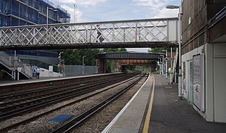
Brockley Lane is a closed railway station in Brockley, south London. It was opened in June 1872 by the London, Chatham and Dover Railway on its Greenwich Park Branch Line. It closed to passengers in January 1917 with the branch, but remained open as a goods station until May 1970.
The Stanhope and Tyne Railway was an early British mineral railway, that ran from Stanhope in County Durham, to South Shields at the mouth of the River Tyne. The object was to convey limestone from Stanhope and coal from West Consett and elsewhere to the Tyne, and to local consumers. Passengers were later carried on parts of the line.
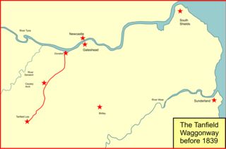
The Brandling Junction Railway was an early railway in County Durham, England. It took over the Tanfield Waggonway of 1725 that was built to bring coal from Tanfield to staiths on the River Tyne at Dunston. The Brandling Junction Railway itself opened in stages from 1839, running from Gateshead to Wearmouth and South Shields. Wearmouth was regarded at the time as the "Sunderland" terminal.

Washington railway station served the town of Washington, Tyne and Wear, England from 1835 to 1963, initially on the Stanhope & Tyne Railway and later the Leamside line.