
Newcastle upon Tyne, or simply Newcastle, is a city and metropolitan borough in Tyne and Wear, England. The city is located on the River Tyne's northern bank and forms the largest part of the Tyneside built-up area. Newcastle is also the most populous city of North East England. Newcastle developed around a Roman settlement called Pons Aelius and the settlement later took the name of a castle built in 1080 by William the Conqueror's eldest son, Robert Curthose.

Tyne and Wear is a metropolitan county in North East England, situated around the mouths of the rivers Tyne and Wear. It was created in 1974, by the Local Government Act 1972, along with five metropolitan boroughs of Gateshead, Newcastle upon Tyne, Sunderland, North Tyneside and South Tyneside. It is bordered by Northumberland to the north and Durham to the south; the county boundary was formerly split between these counties with the border as the River Tyne.

Wallsend is a town in North Tyneside, England, at the eastern end of Hadrian's Wall. It has a population of 43,842 and lies 3.5 miles east of Newcastle upon Tyne.

South Tyneside is a metropolitan borough in the metropolitan county of Tyne and Wear, North East England.

North Tyneside is a metropolitan borough in the metropolitan county of Tyne and Wear, England. It forms part of the greater Tyneside conurbation. North Tyneside Council is headquartered at Cobalt Park, Wallsend.
South Shields is a coastal town in South Tyneside, Tyne and Wear, England. It is situated at the south of the River Tyne. Historically, it was known to Romans as Arbeia and as Caer Urfa by Early Middle Ages. According to the 2011 census, the town had a population of 75,337. It is the fourth largest settlement in Tyne and Wear; after Newcastle upon Tyne, Sunderland and Gateshead. It is roughly equidistant (approximately 3.7 miles between the border of Newcastle and the border of Sunderland.

Tynemouth is a coastal town in the metropolitan borough of North Tyneside, North East England. It is located on the north side of the mouth of the River Tyne, hence its name. It is 8 mi (13 km) east-northeast of Newcastle upon Tyne.

North Shields is a coastal resort on the River Tyne's north bank in the North Tyneside borough, northern England. It is a large area of Tynemouth and 8 miles (13 km) north-east of Newcastle upon Tyne.

Newcastle Central Station is a major railway station in Newcastle upon Tyne. It is located on the East Coast Main Line, around 268 miles (432 km) north of London King's Cross. It is the primary national rail station serving Newcastle upon Tyne, with local rail services provided by the Tyne and Wear Metro network to which the station is connected to by Central Station Metro station, situated beneath the national rail station.

The North Tyneside Steam Railway and Stephenson Steam Railway are visitor attractions in North Tyneside, North East England. The museum and railway workshops share a building on Middle Engine Lane adjacent to the Silverlink Retail Park. The railway is a standard gauge line, running south for 2 miles (3.2 km) from the museum to Percy Main. The railway is operated by the North Tyneside Steam Railway Association (NTSRA). The museum is managed by Tyne and Wear Archives and Museums on behalf of North Tyneside Council.
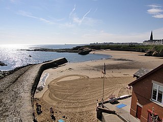
Cullercoats is a coastal settlement in the metropolitan borough of North Tyneside, Tyne and Wear, North East England. Historically in Northumberland, it has now been absorbed into the wider Tyneside conurbation, sitting between Tynemouth to the south and Whitley Bay to the north. The population of this North Tyneside ward at the 2011 census was 9,202.
Wideopen, also occasionally spelled Wide Open, is a village in the North Tyneside metropolitan borough of Tyne and Wear, England, around 5 miles (8.0 km) north of Newcastle.

Ryton is a town in the Metropolitan Borough of Gateshead, Tyne and Wear, England, 5.8 miles (9.3 km) west of Newcastle upon Tyne. Historically in County Durham, it was incorporated into the metropolitan county of Tyne and Wear and the Borough of Gateshead in 1974. In 2011, the population of the Ryton, Crookhill and Stella ward was 8,146.

Backworth is a village in the metropolitan borough of North Tyneside in the county of Tyne and Wear, England, about 3+1⁄2 miles (6 km) west of Whitley Bay on the north east coast. It lies 5 miles (8 km) northeast of Newcastle. Other nearby towns include North Shields to the southeast, Wallsend to the south, and Cramlington to the northwest.

Shiremoor is a Tyne and Wear Metro station, serving the village of Shiremoor, North Tyneside in Tyne and Wear, England. It joined the network on 11 August 1980, following the opening of the first phase of the network, between Haymarket and Tynemouth via Four Lane Ends.

Longbenton is a district of North Tyneside, England. It is largely occupied by an extensive estate originally built as municipal housing by Newcastle City Council in the 1930s and extended in the 1950s. It is served by the Tyne and Wear Metro stations Longbenton Metro station and Four Lane Ends Metro Station. Nearby places are Killingworth, Forest Hall, Four Lane Ends, West Moor, Heaton and South Gosforth, in Newcastle upon Tyne. The Longbenton and Killingworth Urban Area had a population of 34,878 in 2001. This figure increased to 37,070 in 2011.

Northumberland Park is a Tyne and Wear Metro and future National Rail station, serving the village of Backworth and suburbs of Northumberland Park and West Allotment, North Tyneside in Tyne and Wear, England. It joined the network on 11 December 2005, and is the second-newest station on the network as of March 2022.

Shiremoor is a large village in the Metropolitan Borough of North Tyneside. It is located approximately 3+1⁄2 miles inland of Whitley Bay and approximately three miles north of The Tyne Tunnel. One mile or so north of Shiremoor, the extensive built-up areas of North Tyneside change abruptly into green belt stretching north into south east Northumberland. It has a population of 4,782.

Howdon is a largely residential area in the eastern part of Wallsend, Tyne and Wear, England. It consists of High Howdon and the smaller settlement of East Howdon. Much of the High Howdon area was formerly called Willington prior to post-World War II urbanisation. The North Tyneside ward population at the 2011 Census was 11,129.
Percy Main is a small village absorbed into North Shields, North East England. Historically in Northumberland, it is now part of Tyne and Wear.
