
Tyne and Wear is a metropolitan county in North East England, situated around the mouths of the rivers Tyne and Wear. It came into existence in 1974 after the passage of the Local Government Act 1972, which also created the five metropolitan boroughs of Newcastle upon Tyne, Gateshead, North Tyneside, South Tyneside and the City of Sunderland which constitute the county. It is bordered by Northumberland to the north and Durham to the south. Prior to the 1974 reforms, the area now covered by Tyne and Wear was split between the counties of Northumberland and Durham, the border being marked by the River Tyne. The county no longer has any local government powers, following the disbanding of Tyne and Wear County Council, so the county only exists for ceremonial purposes.

Washington is a large town in the City of Sunderland local government district of Tyne and Wear, England, and historically part of County Durham. Washington is equidistant from the centres of Newcastle upon Tyne, Durham and Sunderland, with close ties to all three cities. It is the ancestral settlement of the Washington family, which George Washington descended from.

Sunderland is a port city in Northern England. It is the City of Sunderland's administrative centre, within the Tyne and Wear metropolitan county, historic county of Durham and the North East Combined Authority area. The city is 10 miles (16 km) from Newcastle-upon-Tyne and is on the River Wear's mouth to the North Sea, the river also flows through Durham city roughly 12 miles (19 km) south-west of the city's centre.

South Tyneside is a metropolitan borough in the metropolitan county of Tyne and Wear, North East England.

The Tyne and Wear Metro is an overground and underground light rail rapid transit system serving the city of Newcastle upon Tyne, the metropolitan boroughs of Gateshead, North Tyneside, South Tyneside and the City of Sunderland. The network opened in stages from August 1980 and now serves a total of 60 stations, with two lines covering 48.2 miles (77.6 km) of track. The Metro can be accessed from a mixture of under ground and above ground stations. It has been described as the "first modern light rail system in the United Kingdom". The system is currently owned and operated by the Tyne and Wear Passenger Transport Executive, thus is fully under public ownership and operation.

The A19 is a major road in England running approximately parallel to and east of the A1 road. Although the two roads meet at the northern end of the A19, the two roads originally met at the southern end of the A19 in Doncaster, but the old route of the A1 was changed to the A638. From Sunderland northwards, the route was formerly the A108. In the past the route was known as the East of Snaith-York-Thirsk-Stockton-on-Tees-Sunderland Trunk Road. Most traffic joins the A19, heading for Teesside, from the A168 at Dishforth Interchange.
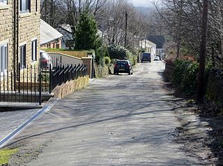
Rowlands Gill is a town situated along the A694, between Winlaton Mill and Hamsterley Mill, on the north bank of the River Derwent, in the Metropolitan Borough of Gateshead, Tyne and Wear, England. Within Gateshead's greenbelt, the town has a picturesque setting with much open space and views across the valley to Gibside Estate, now owned by the National Trust.
South Hylton is a suburb of Sunderland, Tyne and Wear, England. Lying west of Sunderland city centre on the south bank of the River Wear, South Hylton has a population of 10,317. Once a small industrial village, South Hylton is now a dormitory village and is a single track terminus for the Tyne and Wear Metro.

Monkwearmouth is an area of Sunderland, Tyne and Wear in North East England. Monkwearmouth is located at the north side of the mouth of the River Wear. It was one of the three original settlements on the banks of the River Wear along with Bishopwearmouth and Sunderland, the area now known as the East End. It includes the area around St. Peter's Church, founded in 674 as part of Monkwearmouth-Jarrow Abbey, and was once the main centre of Wearside shipbuilding and coalmining in the town. It is now host to a campus of the University of Sunderland and the National Glass Centre. It is served by the three Church of England churches of the Parish of Monkwearmouth. The first nineteenth-century Catholic church built in Monkwearmouth was St Benet's Church which remains active today.

Sunderland is a railway station on the Durham Coast Line, which runs between Newcastle and Middlesbrough via Hartlepool. The station, situated 12 miles 15 chains (19.6 km) south-east of Newcastle, serves the port city of Sunderland in Tyne and Wear, England. It is owned by Network Rail and managed by Northern Trains. Since 31 March 2002, the station has also been served by the Tyne and Wear Metro.
Farringdon is a suburb of Sunderland, Tyne and Wear, England. Originally a Monastic grange and manor estate for hundreds of years, Farringdon was rebuilt as a post-war council housing estate in the 1950s. It is approximately 3 mi (4.8 km) south of the city centre along the A690, close to Thorney Close, Silksworth, East Herrington, Gilley Law and Doxford Park. Electorally, the area comes under the St. Chad's ward of the City.
Southwick is a former village and now a suburb on the north banks of the River Wear in the city of Sunderland in the county of Tyne and Wear, historically in County Durham. From 1894 to 1928, Southwick was administered by the Southwick-on-Wear Urban District Council, before being absorbed by Sunderland.
Willington Quay is an area in the borough of North Tyneside in Tyne and Wear in northern England. It is situated on the north bank of the River Tyne, facing Jarrow, and between Wallsend and North Shields. It is served by the Howdon Metro station in Howdon. The area from 2006 onwards has been an area of new housing built on brownfield sites. The house building continues into 2013 and is changing the social and economic balance in the area. The area has also had a make over of the bowling green off Howdon Lane and further warehousing next to the bowling green has been demolished to make way for further new housing. The changes made recently at Willington Quay are now making it an attractive place to live within North Tyneside.
East Rainton is a village found in the outskirts of Durham, in the City of Sunderland, Tyne and Wear, in the north east of England. It is situated alongside the A690 road between Sunderland and Durham, near Houghton-le-Spring.

Mowbray Park is a municipal park in the centre of Sunderland, Tyne and Wear, England, located a few hundred yards from the busy thoroughfares of Holmeside and Fawcett Street and bordered by Sunderland Museum and Winter Gardens to the north, Burdon Road to the west, Toward Road to the east and Park Road to the south. The park was voted best in Britain in 2008.
Cox Green is a settlement near to Bolton within the Egerton district of Greater Manchester. It is primarily a residential town.
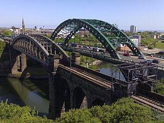
Monkwearmouth Railway Bridge is a railway bridge built in 1879, crossing the River Wear at Sunderland and Monkwearmouth. The bridge lies adjacent to and upstream of the Wearmouth Road Bridge.
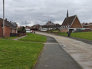
Witherwack is a suburb in the north of Sunderland, Tyne and Wear, England, situated between Red House to the west, Carley Hill to the east and Marley Pots to the south. The origin of the name Witherwack is unknown. The spelling of the name has changed since the Ordnance Survey maps of 1862 on which it was spelled Whitherwhack.
Concord is an area of Washington, a town in Tyne and Wear, England. Historically, Concord was part of County Durham, joining the county of Tyne and Wear in 1974, following its creation.

