
Bethesda station is a rapid transit station on the Red Line of the Washington Metro system in Bethesda, Maryland. It is one of the busiest suburban Metro stations, serving on average 9,142 passengers each weekday in 2017. The Purple Line, a light rail system currently under construction, will terminate at Bethesda, providing rail service to other inner Maryland suburbs such as Silver Spring and College Park, each of which has additional north-south connections by Washington Metro, and New Carrollton, which has Amtrak and MARC connections to both Washington, D.C., and Baltimore.

McPherson Square station is a Washington Metro station in Downtown, Washington, D.C., United States. The side-platformed station is operated by the Washington Metropolitan Area Transit Authority (WMATA). Providing service for the Blue, Orange, and Silver Lines, the station is located between McPherson Square and Franklin Square, with two entrances on I Street at Vermont Avenue and 14th Street NW. This is the main station to access the White House, and the Vermont Avenue exit is directly underneath the Department of Veterans Affairs building.

Federal Triangle station is a Washington Metro station in Washington, D.C., United States. The island-platformed station was opened on July 1, 1977, and is operated by the Washington Metropolitan Area Transit Authority (WMATA). Providing service for the Blue, Orange, and Silver Lines, the station's entrance is beneath the William Jefferson Clinton Federal Building.

Smithsonian station is a Washington Metro station at the National Mall in Washington, D.C., United States. The side platformed station was opened on July 1, 1977, and is operated by the Washington Metropolitan Area Transit Authority (WMATA). It is a stop on the Blue, Orange and Silver Lines. The station's south entrance is at the southwest corner of Independence Avenue and 12th Street, Southwest, the street elevator is at the northwest corner of the same intersection, and the north entrance is on the south side of the Mall near Jefferson Drive, Southwest.
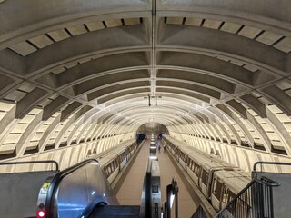
Mount Vernon Square station is a Washington Metro station in Washington, D.C., on the Green and Yellow Lines. It is the northeastern terminus of the Yellow Line.

Capitol South station is a Washington Metro station in the Capitol Hill neighborhood of Washington, D.C., United States. The island-platformed station was opened on July 1, 1977, and is operated by the Washington Metropolitan Area Transit Authority (WMATA). The station currently provides service for the Blue, Orange, and Silver Lines.

Eastern Market station is a Washington Metro station in the Capitol Hill neighborhood of Washington, D.C., United States. The island platformed station was opened on July 1, 1977, and is operated by the Washington Metropolitan Area Transit Authority (WMATA). The station currently provides service for the Blue, Orange, and Silver Lines. The station is located in Southeast D.C. at Pennsylvania Avenue and 7th Street. It is named after the nearby Eastern Market, a historic public marketplace.

Potomac Avenue station is an island-platformed Washington Metro station in the Capitol Hill neighborhood of Washington, D.C., United States. The station was opened on July 1, 1977, and is operated by the Washington Metropolitan Area Transit Authority (WMATA). The station currently provides service for the Blue, Orange, and Silver Lines. The station serves a dense residential area of Southeast Washington around Potomac Avenue and is located at 14th and G Streets.

Stadium–Armory station is a Washington Metro station in Southeast, Washington, D.C. It is located at the border of the Barney Circle and Kingman Park neighborhoods. The station was opened on July 1, 1977, and is operated by the Washington Metropolitan Area Transit Authority (WMATA). Stadium–Armory serves the Blue, Orange and Silver Lines. It is a transfer station, as this is the last station shared by the three lines before the lines diverge going east; east of the station, all three lines rise above ground onto elevated track to cross the Anacostia River. At the diverge point, the Orange Line continues above ground veering northbound towards the Minnesota Avenue station, and the Blue and Silver Lines continue eastbound entering a tunnel towards Benning Road.
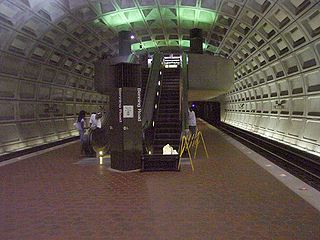
Benning Road station is an island-platformed Washington Metro station in the Benning Ridge neighborhood of Northeast Washington, D.C., United States. The station was opened on November 22, 1980, and is operated by the Washington Metropolitan Area Transit Authority (WMATA). Providing service for the Blue and Silver Lines, the station is located in a residential area near the intersection of Benning Road and East Capitol Street. It is the first station after the Blue and Silver Lines diverge from the Orange Line east of the Anacostia River, and also the last station in the District of Columbia going east.
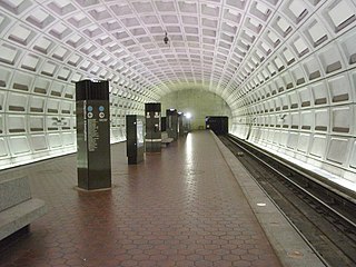
Capitol Heights station is an island-platformed Washington Metro station in Capitol Heights, Maryland, United States. The station was opened on November 22, 1980, and is operated by the Washington Metropolitan Area Transit Authority (WMATA). Providing service for the Blue and Silver Lines, the station is located at 133 Central Avenue in a residential area at East Capitol Street and Southern Avenue SE. This is the first station on the two lines in Maryland going east. As of 2017, in terms of weekday average boardings, it is the least used underground station in the system and the 10th least used station overall.

Minnesota Avenue station is an island-platformed Washington Metro station in the Central Northeast/Mahaning Heights neighborhood of Northeast Washington, D.C., United States. The station was opened on November 20, 1978, and is operated by the Washington Metropolitan Area Transit Authority (WMATA).

Deanwood station is an island-platformed Washington Metro station in the Deanwood neighborhood of Northeast Washington, D.C., United States. The station was opened on November 20, 1978, and is operated by the Washington Metropolitan Area Transit Authority (WMATA). Providing service for only the Orange Line, the station is the final station in the District of Columbia going east. The station is located at Minnesota Avenue and 48th Street Northeast.
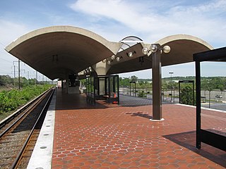
Landover station is an island-platformed Washington Metro station in Landover, Maryland, United States. The station was opened on November 20, 1978, and is operated by the Washington Metropolitan Area Transit Authority (WMATA). Providing service for the Orange Line, the station is in a residential area of Landover at Pennsy Drive near Landover Road. It is primarily a commuter station, with parking for over 1,800 cars, but it also served the now-demolished Capital Centre, the former home of the Washington Bullets and Washington Capitals.

Columbia Heights station is a Washington Metro station in Washington, D.C., on the Green Line. Due to successful redevelopment since the station's opening, Columbia Heights is one of the busiest Metro stops outside the downtown core, with over four million exits in 2010.

Navy Yard–Ballpark station is a Washington Metro station in Washington, D.C., on the Green Line. The station is located in the Navy Yard/Near Southeast neighborhood of Southeast, with entrances on M Street at Half Street and New Jersey Avenue.

Southern Avenue station is an island platformed Washington Metro station in Prince George's County, Maryland, United States. The station was opened on January 13, 2001, and is operated by the Washington Metropolitan Area Transit Authority (WMATA). Providing service for only the Green Line, the station is located on the southern side of Southern Avenue, putting it just outside the District of Columbia, opposite Valley Terrace straddling the D.C/Maryland border. Southern Avenue is the first station in Maryland going southeast on the Green Line.

Naylor Road station is an island-platformed Washington Metro station in Hillcrest Heights, Maryland, United States. The station was opened on January 13, 2001, and is operated by the Washington Metropolitan Area Transit Authority (WMATA). Providing service for only the Green Line, the station is located between Naylor Road, Branch Avenue, and Suitland Parkway.

Suitland station is an island platformed Washington Metro station in Suitland, Maryland, United States. The station was opened on January 13, 2001, and is operated by the Washington Metropolitan Area Transit Authority (WMATA). The station is located at Silver Hill Road and Suitland Parkway, providing service for only the Green Line,.
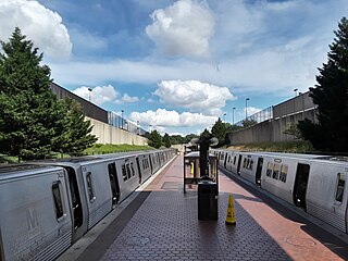
Branch Avenue station is an island-platformed Washington Metro station in Suitland, Maryland, United States. The station was opened on January 13, 2001, and is operated by the Washington Metropolitan Area Transit Authority (WMATA). The station presently serves as the southeastern terminus for the Green Line, with the Branch Avenue rail yard lying just beyond this station. The station is located near the intersection of Auth Road and Old Soper Road.


