List of Washington Metro stations

Last updated

The Washington Metro (commonly called Metro, and branded Metrorail) is a rapid transit system serving Washington, D.C. and neighboring communities in Maryland and Virginia, both inside and outside the Capital Beltway. With an average weekday ridership of 764,300, the Washington Metro is the second-busiest rapid transit system in the United States, behind the New York City Subway. [1] As of 2023, the system has 98 active stations on six lines with 129 miles (208 km) of tracks.

Contents

The Washington Metro system was conceived as an alternative to constructing a large freeway system throughout the Washington, D.C. area. It was partially financed with funds originally dedicated to highway construction. [2] Construction began in 1969, and in 1976 the first section of the Metro system opened along the Red Line between the Farragut North and Rhode Island Avenue stations in Washington, D.C. Throughout the 1970s and 1980s, more stations were opened in the city and the suburban communities of Arlington County, the City of Alexandria, and Fairfax County in Virginia as well as Montgomery and Prince George's Counties in Maryland. By 1991, five rail lines were open: the Red, Orange, Yellow, Green, and Blue Lines. The system, as originally planned, was completed in 2001 with the extension of the Green Line to Branch Avenue. In 2004, three stations were opened: an extension of the Blue Line to the Morgan Boulevard and Downtown Largo stations and the first infill station, NoMa–Gallaudet U. [3] The Silver Line opened in two phases, adding five stations in 2014 and six in 2022. [4] [5] On the Yellow and Blue Lines, an additional infill station at Potomac Yard opened on May 19, 2023. [6]

Nine Metrorail stations are officially designated transfer stations, although other intermediate stations also allow passengers to transfer between lines. Four of these stations have separate, perpendicular upper and lower levels, which open at different times. Two other transfer stations, Rosslyn and Pentagon, have parallel stacked platforms. Ten stations are termini (stations at the end of lines); several other non-terminus stations are used to short turn trains in regular service. [7]

The busiest station in the system in 2023 was Metro Center, with more than 3.9 million passenger entries over the course of the year. [8] Rosslyn was the busiest station in Virginia, while Silver Spring was the busiest in Maryland. The system's 10 busiest stations are all located in Washington.

Lines

There are six Washington Metro lines, each named for a different color. [7] All lines except the Red Line share tracks.

LineRidership (May 2010) [9] Stations [7] Termini [7]
WMATA Red.svg 277,741 (37%)27 Shady Grove Glenmont
WMATA Orange.svg 187,663 (25%)26 Vienna New Carrollton
WMATA Blue.svg 120,104 (16%)28 Franconia–Springfield Downtown Largo
WMATA Green.svg 105,091 (14%)21 Branch Avenue Greenbelt
WMATA Yellow.svg 59,781 (8%)13 Huntington Mount Vernon Square
WMATA Silver.svg 34 Ashburn Downtown Largo

Stations

Pylon by the entrance to the Archives-Navy Memorial-Penn Quarter station Archives-Navy Memorial-Penn Quarter pylon.jpg
Pylon by the entrance to the Archives-Navy Memorial-Penn Quarter station
Passengers boarding a train at the Bethesda station Washington DC metro station bethesda.jpg
Passengers boarding a train at the Bethesda station
Crossvault of the L'Enfant Plaza station L'Enfant Plaza station crossvault.jpg
Crossvault of the L'Enfant Plaza station
Union Station, the busiest station in the system Union Station (Washington Metro).jpg
Union Station, the busiest station in the system
The longest continuous escalator in the western hemisphere, at the Wheaton station Wheaton (Metro de Washington).jpg
The longest continuous escalator in the western hemisphere, at the Wheaton station
Vaulted ceiling at Farragut West Farragut West station.jpg
Vaulted ceiling at Farragut West
Largo Town Center station, one of the newest stations Washington DC metro station largo town center.jpg
Largo Town Center station, one of the newest stations
Arlington Cemetery station on a snowy day Arlington Cemetery Metro station.jpg
Arlington Cemetery station on a snowy day
Elevated platform at National Airport National Airport Station.jpg
Elevated platform at National Airport
Wiehle-Reston East station on the first day of Silver Line service in 2014 Wiehle-Reston Metro platform 1.jpg
Wiehle-Reston East station on the first day of Silver Line service in 2014
*Official transfer stations
Terminals
*†Transfer station and terminal
Station [7] Lines [7] Rail Connections [9] Jurisdiction [9] Avg. Weekday Daily
Rail Entries (2023) [10]
Opened [5] [9]
Addison Road WMATA Blue.svg WMATA Silver.svg Capitol Heights, Maryland 1285Nov 22, 1980
Anacostia WMATA Green.svg Washington, D.C. (southeast)2507Dec 28, 1991
Archives WMATA Green.svg WMATA Yellow.svg Washington, D.C. (northwest)3852Apr 30, 1983
Arlington Cemetery WMATA Blue.svg Arlington County, Virginia 897Jul 1, 1977
Ashburn WMATA Silver.svg Ashburn, Virginia 1152Nov 15, 2022
Ballston–MU WMATA Orange.svg WMATA Silver.svg Arlington County, Virginia 5289Dec 11, 1979
Benning Road WMATA Blue.svg WMATA Silver.svg Washington, D.C. (northeast)1355Nov 22, 1980
Bethesda WMATA Red.svg Bethesda, Maryland 4517Aug 25, 1984
Braddock Road WMATA Blue.svg WMATA Yellow.svg Alexandria, Virginia 2040Dec 17, 1983
Branch Avenue WMATA Green.svg Suitland, Maryland 2141Jan 13, 2001
Brookland–CUA WMATA Red.svg Washington, D.C. (northeast)3536Feb 6, 1978
Capitol Heights WMATA Blue.svg WMATA Silver.svg Prince George's County, Maryland 1009Nov 22, 1980
Capitol South WMATA Orange.svg WMATA Blue.svg WMATA Silver.svg District of Columbia 4778Jul 1, 1977
Cheverly WMATA Orange.svg Prince George's County, Maryland 461Nov 20, 1978
Clarendon WMATA Orange.svg WMATA Silver.svg Arlington, Virginia 2524Dec 11, 1979
Cleveland Park WMATA Red.svg District of Columbia 2105Dec 5, 1981
College Park–University of Maryland WMATA Green.svg MARC train.svg MARC: Camden Prince George's County, Maryland 1647Dec 11, 1993
Columbia Heights WMATA Green.svg District of Columbia 6478Sep 18, 1999
Congress Heights WMATA Green.svg District of Columbia 1357Jan 13, 2001
Court House WMATA Orange.svg WMATA Silver.svg Arlington, Virginia 3348Dec 11, 1979
Crystal City WMATA Blue.svg WMATA Yellow.svg Virginia Railway Express.svg VRE: Fredericksburg Manassas Arlington, Virginia 4795Jul 1, 1977
Deanwood WMATA Orange.svg District of Columbia 721Nov 20, 1978
Downtown Largo WMATA Blue.svg WMATA Silver.svg Prince George's County, Maryland 1835Dec 18, 2004
Dulles International Airport BSicon FLUG.svg WMATA Silver.svg Loudoun County, Virginia 1705Nov 15, 2022
Dunn Loring WMATA Orange.svg Fairfax County, Virginia 1349Jun 7, 1986
Dupont Circle WMATA Red.svg District of Columbia 8986Jan 17, 1977
East Falls Church* WMATA Orange.svg WMATA Silver.svg Arlington, Virginia 2225Jun 7, 1986
Eastern Market WMATA Orange.svg WMATA Blue.svg WMATA Silver.svg District of Columbia 3198Jul 1, 1977
Eisenhower Avenue WMATA Yellow.svg Alexandria, Virginia 1011Dec 17, 1983
Farragut North WMATA Red.svg District of Columbia 9820Mar 29, 1976
Farragut West WMATA Orange.svg WMATA Blue.svg WMATA Silver.svg District of Columbia 9214Jul 1, 1977
Federal Center SW WMATA Orange.svg WMATA Blue.svg WMATA Silver.svg District of Columbia 2231Jul 1, 1977
Federal Triangle WMATA Orange.svg WMATA Blue.svg WMATA Silver.svg District of Columbia 3711Jul 1, 1977
Foggy Bottom–GWU WMATA Orange.svg WMATA Blue.svg WMATA Silver.svg District of Columbia 12,007Jul 1, 1977
Forest Glen WMATA Red.svg Montgomery County, Maryland 1104Sep 22, 1990
Fort Totten* (lower level) [a] WMATA Green.svg District of Columbia 6376Dec 11, 1993
Fort Totten* (upper level) [a] WMATA Red.svg Feb 6, 1978
Franconia–Springfield* WMATA Blue.svg Virginia Railway Express.svg VRE: Fredericksburg Fairfax County, Virginia 2917Jun 29, 1997
Friendship Heights WMATA Red.svg District of Columbia 3501Aug 25, 1984
Gallery Place* (lower level) [a] WMATA Green.svg WMATA Yellow.svg District of Columbia 10,525Apr 30, 1983
Gallery Place* (upper level) [a] WMATA Red.svg Dec 15, 1976
Georgia Avenue–Petworth WMATA Green.svg District of Columbia 3363Sep 18, 1999
Glenmont WMATA Red.svg Montgomery County, Maryland 2904Jul 25, 1998
Greensboro WMATA Silver.svg Fairfax County, Virginia 852Jul 26, 2014
Greenbelt* WMATA Green.svg MARC train.svg MARC: Camden Prince George's County, Maryland 2254Dec 11, 1993
Grosvenor–Strathmore WMATA Red.svg Montgomery County, Maryland 2128Aug 25, 1984
Herndon WMATA Silver.svg Fairfax County, Virginia 784Nov 15, 2022
Huntington WMATA Yellow.svg Fairfax County, Virginia 3006Dec 17, 1983
Hyattsville Crossing WMATA Green.svg Prince George's County, Maryland 2020Dec 11, 1993
Innovation Center WMATA Silver.svg Fairfax County, Virginia 681Nov 15, 2022
Judiciary Square WMATA Red.svg District of Columbia 3263Mar 29, 1976
King Street–Old Town* WMATA Blue.svg WMATA Yellow.svg Virginia Railway Express.svg VRE: Fredericksburg Manassas
(at Alexandria Union Station)
Alexandria, Virginia 3429Dec 17, 1983
L'Enfant Plaza* (lower level) [a] WMATA Orange.svg WMATA Blue.svg WMATA Silver.svg Virginia Railway Express.svg VRE: Fredericksburg Manassas
(at L'Enfant)
District of Columbia 8792Jul 1, 1977
L'Enfant Plaza* (upper level) [a] WMATA Green.svg WMATA Yellow.svg Apr 30, 1983
Landover WMATA Orange.svg Prince George's County, Maryland 756Nov 20, 1978
Loudoun Gateway WMATA Silver.svg Loudoun County, Virginia 258Nov 15, 2022
McLean WMATA Silver.svg Fairfax County, Virginia 1607Jul 26, 2014
McPherson Square WMATA Orange.svg WMATA Blue.svg WMATA Silver.svg District of Columbia 6510Jul 1, 1977
Medical Center WMATA Red.svg Montgomery County, Maryland 2834Aug 25, 1984
Metro Center* (upper level) [a] WMATA Red.svg District of Columbia 12,644Mar 29, 1976
Metro Center* (lower level) [a] WMATA Orange.svg WMATA Blue.svg WMATA Silver.svg District of Columbia 12,644Jul 1, 1977
Minnesota Avenue WMATA Orange.svg District of Columbia 1072Nov 20, 1978
Morgan Boulevard WMATA Blue.svg WMATA Silver.svg Prince George's County, Maryland 818Dec 18, 2004
Mount Vernon Square* WMATA Green.svg WMATA Yellow.svg District of Columbia 2908May 11, 1991
Navy Yard–Ballpark WMATA Green.svg District of Columbia 6595Dec 28, 1991
Naylor Road WMATA Green.svg Prince George's County, Maryland 956Jan 13, 2001
New Carrollton* WMATA Orange.svg BSicon LOGO Amtrak2.svg Amtrak: Northeast Regional , Palmetto , Vermonter
MARC train.svg MARC: Penn
Prince George's County, Maryland 2756Nov 20, 1978
NoMa–Gallaudet U WMATA Red.svg District of Columbia 7576Nov 20, 2004
North Bethesda WMATA Red.svg Montgomery County, Maryland 1756Dec 15, 1984
Pentagon* WMATA Blue.svg WMATA Yellow.svg Arlington, Virginia 6813Jul 1, 1977
Pentagon City WMATA Blue.svg WMATA Yellow.svg Arlington, Virginia 6329Jul 1, 1977
Potomac Avenue WMATA Orange.svg WMATA Blue.svg WMATA Silver.svg District of Columbia 2047Jul 1, 1977
Potomac Yard WMATA Blue.svg WMATA Yellow.svg Alexandria, Virginia 1205May 19, 2023
Reston Town Center WMATA Silver.svg Fairfax County, Virginia 734Nov 15, 2022
Rhode Island Avenue WMATA Red.svg District of Columbia 3422Mar 29, 1976
Rockville WMATA Red.svg BSicon LOGO Amtrak2.svg Amtrak: Capitol Limited
MARC train.svg MARC: Brunswick
Montgomery County, Maryland 2098Dec 15, 1984
Ronald Reagan Washington
National Airport
20 airtransportation.svg
WMATA Blue.svg WMATA Yellow.svg Arlington, Virginia 4748Jul 1, 1977
Rosslyn* WMATA Orange.svg WMATA Blue.svg WMATA Silver.svg Arlington, Virginia 6989Jul 1, 1977
Shady Grove WMATA Red.svg Montgomery County, Maryland 5073Dec 15, 1984
Shaw–Howard University WMATA Green.svg District of Columbia 2655May 11, 1991
Silver Spring WMATA Red.svg MARC train.svg MARC: Brunswick Montgomery County, Maryland 5394Feb 6, 1978
Smithsonian WMATA Orange.svg WMATA Blue.svg WMATA Silver.svg District of Columbia 4917Jul 1, 1977
Southern Avenue WMATA Green.svg Prince George's County, Maryland 1944Jan 13, 2001
Spring Hill WMATA Silver.svg Fairfax County, Virginia 609Jul 26, 2014
Stadium–Armory* WMATA Orange.svg WMATA Blue.svg WMATA Silver.svg District of Columbia 1469Jul 1, 1977
Suitland WMATA Green.svg Prince George's County, Maryland 1735Jan 13, 2001
Takoma WMATA Red.svg District of Columbia 2884Feb 6, 1978
Tenleytown–AU WMATA Red.svg District of Columbia 3385Aug 25, 1984
Twinbrook WMATA Red.svg Montgomery County, Maryland 2095Dec 15, 1984
Tysons WMATA Silver.svg Fairfax County, Virginia 1815Jul 26, 2014
U Street WMATA Green.svg District of Columbia 3743May 11, 1991
Union Station WMATA Red.svg MARC train.svg MARC: Brunswick Camden Penn
Virginia Railway Express.svg VRE: Fredericksburg Manassas
BSicon TRAM1.svg DC Streetcar
(at Union Station)
District of Columbia 12,056Mar 29, 1976
Van Dorn Street WMATA Blue.svg Alexandria, Virginia 1280Jun 15, 1991
Van Ness–UDC WMATA Red.svg District of Columbia 2872Dec 5, 1981
Vienna WMATA Orange.svg Fairfax County, Virginia 3136Jun 7, 1986
Virginia Square–GMU WMATA Orange.svg WMATA Silver.svg Arlington, Virginia 1952Dec 11, 1979
Waterfront WMATA Green.svg District of Columbia 2940Dec 28, 1991
West Falls Church WMATA Orange.svg Fairfax County, Virginia 1169Jun 7, 1986
West Hyattsville WMATA Green.svg Prince George's County, Maryland 1794Dec 11, 1993
Wheaton WMATA Red.svg Montgomery County, Maryland 1877Sep 22, 1990
Wiehle–Reston East WMATA Silver.svg Fairfax County, Virginia 1567Jul 26, 2014
Woodley Park WMATA Red.svg District of Columbia 3331Dec 5, 1981

Notes

Related Research Articles

<span class="mw-page-title-main">Washington Metro</span> Rapid transit system serving the Washington metropolitan area

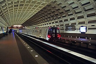
The Washington Metro, often abbreviated as the Metro and formally the Metrorail, is a rapid transit system serving the Washington metropolitan area of the United States. It is administered by the Washington Metropolitan Area Transit Authority (WMATA), which also operates the Metrobus service under the Metro name. Opened in 1976, the network now includes six lines, 98 stations, and 129 miles (208 km) of route.

<span class="mw-page-title-main">Foggy Bottom–GWU station</span> Washington Metro station

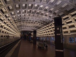
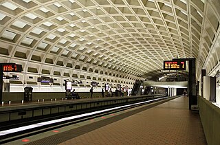
Foggy Bottom–GWU station is an Washington Metro station in the Foggy Bottom neighborhood of Washington, D.C., United States. The island-platformed station was opened on July 1, 1977, and is operated by the Washington Metropolitan Area Transit Authority (WMATA). Providing service for the Blue, Orange, and Silver Lines, the station is located on I Street on the George Washington University (GWU) campus. It is the last westbound station in the District of Columbia on these lines before they dive under the Potomac River to Virginia.

<span class="mw-page-title-main">Blue Line (Washington Metro)</span> Washington Metro rapid transit line

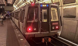
The Blue Line is a rapid transit line of the Washington Metro system, consisting of 28 stations in Fairfax County, Alexandria and Arlington, Virginia; Washington, D.C.; and Prince George's County, Maryland, United States. The Blue Line runs from Franconia–Springfield to Downtown Largo. The line shares track with the Orange Line for 13 stations, the Silver Line for 18, and the Yellow Line for 7. Only 3 stations are exclusive to the Blue Line.

<span class="mw-page-title-main">Orange Line (Washington Metro)</span> Washington Metro rapid transit line

The Orange Line is a rapid transit line of the Washington Metro system, consisting of 26 stations in Fairfax County and Arlington, Virginia; the District of Columbia; and Prince George's County, Maryland, United States. The Orange Line runs from Vienna in Virginia to New Carrollton in Maryland. Half of the line's stations are shared with the Blue Line and over two thirds are shared with the Silver Line. Orange Line service began on November 20, 1978.

<span class="mw-page-title-main">Red Line (Washington Metro)</span> Washington Metro rapid transit line

The Red Line is a rapid transit line of the Washington Metro system, consisting of 27 stations in Montgomery County, Maryland, and Washington, D.C., in the United States. It is a primary line through downtown Washington and the oldest and busiest line in the system. It forms a long, narrow "U," capped by its terminal stations at Shady Grove and Glenmont.

<span class="mw-page-title-main">Yellow Line (Washington Metro)</span> Washington Metro rapid transit line

The Yellow Line is a rapid transit line of the Washington Metro system that runs between Huntington in Virginia and Mount Vernon Square in Washington, D.C. It consists of 13 stations in Fairfax County, the city of Alexandria, and Arlington County in Virginia, as well as Washington, D.C. It is the shortest line in the system, and since its truncation to Mount Vernon Square, it is the only line that does not enter Maryland.

<span class="mw-page-title-main">Shady Grove station</span> Washington Metro station

Shady Grove station is a Washington Metro station in Redland, Maryland, United States. The station opened on December 15, 1984 as part of a four-stop extension of the Red Line from Grosvenor–Strathmore station to Shady Grove. The station is operated by the Washington Metropolitan Area Transit Authority (WMATA).

<span class="mw-page-title-main">East Falls Church station</span> Washington Metro station

East Falls Church station is an island platformed Washington Metro station in Arlington County, Virginia, on the Orange and Silver Lines. East Falls Church station is the last aboveground, at-grade, or open-cut station for eastbound trains. East of this station, the trains enter tunnels.

<span class="mw-page-title-main">Virginia Square–GMU station</span> Washington Metro station

Virginia Square–GMU station is a Washington Metro station in the Virginia Square neighborhood of Arlington, Virginia, United States. The side platformed station opened on December 1, 1979, and is operated by the Washington Metropolitan Area Transit Authority (WMATA). The station serves the Orange and Silver Lines. The station serves the Virginia Square neighborhood as well as the Arlington campus of George Mason University (GMU). The station entrance is located at the intersection of Fairfax Drive and North Monroe Street.

<span class="mw-page-title-main">Court House station</span> Washington Metro station

Court House station is an island platformed Washington Metro station in the Courthouse neighborhood of Arlington, Virginia, United States. The station was opened on December 1, 1979, and is operated by the Washington Metropolitan Area Transit Authority (WMATA). Weekday ridership is approximately 7,000 passengers per day. The station serves the Orange and Silver Lines.

<span class="mw-page-title-main">Rosslyn station</span> Washington Metro station

Rosslyn station is the westernmost station on the shared segment of the Blue, Orange, and Silver lines of the Washington Metro. It is located in the Rosslyn neighborhood of Arlington, Virginia, United States. Rosslyn is the first station in Virginia heading westward from the District on the Orange and Silver Lines and southward on the Blue Line. It is one of four interchange points on the Metrorail system west of the Potomac River and located in a growing business district.

<span class="mw-page-title-main">Farragut West station</span> Washington Metro station

Farragut West station is a Washington Metro station in downtown Washington, D.C., United States. The side-platformed station was opened on July 1, 1977, and is operated by the Washington Metropolitan Area Transit Authority (WMATA). Providing service for the Blue, Silver, and Orange Lines, the station is located just west of Farragut Square with two entrances on I Street at 17th and 18th Streets NW.

<span class="mw-page-title-main">Franconia–Springfield station</span> Washington Metro station

Franconia–Springfield station is a Washington Metro rapid transit station and Virginia Railway Express commuter rail station located in Springfield, Virginia, United States. The station is the southwestern terminus of the Metro Blue Line and an intermediate station on the VRE Fredericksburg Line. It is also a major bus terminal for Fairfax Connector buses, plus other local and intercity bus routes. The station has one island-platform serving the two Metro tracks, plus two side platforms serving the RF&P Subdivision on which the Fredericksburg Line runs.

<span class="mw-page-title-main">Ronald Reagan Washington National Airport station</span> Washington Metro station

Ronald Reagan Washington National Airport station is a Washington Metro station in Arlington, Virginia on the Blue and Yellow Lines. The station platform is elevated and covered and is the last above-ground station on the Yellow Line in Virginia, heading into Washington, D.C. It is one of only two stations in the system to have three tracks. The station is located across Smith Boulevard from Terminal 2 at Ronald Reagan Washington National Airport; the mezzanine is directly connected to Level 2 of the terminal by two pedestrian bridges. Airport shuttle buses or a walkway connect the station and Terminal 1. The airport's Abingdon Plantation historical site is near the station.

<span class="mw-page-title-main">L'Enfant Plaza station</span> Washington Metro and VRE station

L'Enfant Plaza station is an intermodal transit station complex located at L'Enfant Plaza in the Southwest Federal Center neighborhood of Washington, D.C. It consists of an underground Washington Metro rapid transit station and an elevated Virginia Railway Express commuter rail station.

<span class="mw-page-title-main">Federal Center SW station</span> Washington Metro station

Federal Center SW station is a Washington Metro station in an area known as the Southwest Federal Center in Washington, D.C., United States. The island-platformed station was opened on July 1, 1977, and is operated by the Washington Metropolitan Area Transit Authority (WMATA) and is located on the Orange, Silver, and Blue Lines. The station is located at 3rd and D Streets.

<span class="mw-page-title-main">Potomac Avenue station</span> Washington Metro station

Potomac Avenue station is an island-platformed Washington Metro station in the Capitol Hill neighborhood of Washington, D.C., United States. The station was opened on July 1, 1977, and is operated by the Washington Metropolitan Area Transit Authority (WMATA). The station currently provides service for the Blue, Orange, and Silver Lines. The station serves a dense residential area of Southeast Washington around Potomac Avenue and is located at 14th and G Streets.

<span class="mw-page-title-main">Stadium–Armory station</span> Washington Metro station

Stadium–Armory station is a Washington Metro station in Southeast, Washington, D.C. It is located at the border of the Barney Circle and Kingman Park neighborhoods. The station was opened on July 1, 1977, and is operated by the Washington Metropolitan Area Transit Authority (WMATA). Stadium–Armory serves the Blue, Orange and Silver Lines. It is a transfer station, as this is the last station shared by the three lines before the lines diverge going east; east of the station, all three lines rise above ground onto elevated track to cross the Anacostia River. At the diverge point, the Orange Line continues above ground veering northbound towards the Minnesota Avenue station, and the Blue and Silver Lines continue eastbound entering a tunnel towards Benning Road.

<span class="mw-page-title-main">Washington Metropolitan Area Transit Authority</span> Public transit authority

The Washington Metropolitan Area Transit Authority, commonly referred to as Metro, is a tri-jurisdictional public transit agency that operates transit service in the Washington metropolitan area. WMATA was created by the United States Congress as an interstate compact between Washington, D.C., Maryland, and Virginia.

<span class="mw-page-title-main">Potomac Yard station</span> Washington Metro station

Potomac Yard station is a Washington Metro station in Alexandria, Virginia, United States. It is operated by the Washington Metropolitan Area Transit Authority (WMATA), serving both the Blue and Yellow Lines, and opened on May 19, 2023. It is located at Alexandria's 7.5-million-square-foot (700,000 m2) Potomac Yard mixed-use development bounded by Richmond Highway and the George Washington Memorial Parkway. It is the second infill station to be added to the Washington Metro system, after NoMa–Gallaudet U in 2004. It was constructed on the site of Potomac Yard, a former railroad freight yard.

References

  1. "Transit Ridership Report: First Quarter 2015" (PDF). American Public Transportation Association. May 27, 2015. Archived from the original (PDF) on September 23, 2015. Retrieved August 26, 2015.
  2. Schrag, Zachary (2006). The Great Society Subway: A History of the Washington Metro. Johns Hopkins University Press. ISBN   0-8018-8246-X.
  3. "WMATA History" (PDF). Washington Metropolitan area Transit Authority. 2007. Archived from the original (PDF) on October 15, 2012. Retrieved August 26, 2015.
  4. George, Justin (June 9, 2022). "Metro's Silver Line extension moves closer to finish line". The Washington Post.
  5. 1 2 3 "Metro Facts" (PDF). Washington Metropolitan area Transit Authority. 2014. Archived from the original (PDF) on February 22, 2016. Retrieved August 26, 2015.
  6. Laris, Michael (May 19, 2023). "Potomac Yard Metro station, decades in the making, opens in Alexandria". Washington Post . Retrieved May 19, 2023.
  7. 1 2 3 4 5 6 "Stations". Washington Metropolitan Area Transit Authority. Retrieved December 28, 2017.
  8. "Metrorail Ridership Summary". Washington Metropolitan Area Transit Authority. Retrieved January 10, 2024.
  9. 1 2 3 4 "Metro Media Guide" (PDF). Washington Metropolitan Area Transit Authority. 2010. Archived from the original (PDF) on July 28, 2012. Retrieved July 14, 2011.
  10. "Rail Ridership Data Viewer | WMATA". www.wmata.com. Retrieved January 8, 2024.