
Washington, D.C., formally the District of Columbia, also known as Washington, the District, or D.C., is the capital city and federal district of the United States. It is located on the east bank of the Potomac River, which forms its southwestern border with Virginia, and it shares a land border with Maryland on its other sides. The city was named for George Washington, a Founding Father, commanding general of the Continental Army during the Revolutionary War, and the first president of the United States, and the district is named after Columbia, the female personification of the nation. Washington is the southern point of the Northeast megalopolis, a major cultural, political, and economic corridor along the northeastern coast of the United States running from Boston to Washington, D.C.. As the seat of the U.S. federal government and several international organizations, the city is an important world political capital. It is one of the most visited cities in the U.S., with over 20 million annual visitors as of 2016.

Ronald Reagan Washington National Airport, sometimes referred to colloquially as National Airport, Washington National, Reagan National, DCA, Reagan, or simply National, is an international airport in Arlington County, Virginia, across the Potomac River from Washington, D.C. It is the smaller of two airports operated by the Metropolitan Washington Airports Authority (MWAA) that serve the National Capital Region (NCR) around Washington, D.C.. The airport is 5 miles (8.0 km) from downtown Washington, D.C., and the city is visible from the airport.

A heliport is a small airport suitable for use by helicopters and some other vertical lift aircraft. Designated heliports typically contain one or more touchdown and liftoff areas and may also have limited facilities such as fuel or hangars. In some larger towns and cities, customs facilities may also be available.

Joint Base Anacostia–Bolling (JBAB) is a 905-acre (366 ha) military installation, located in Southeast, Washington, D.C., established on 1 October 2010 in accordance with congressional legislation implementing the recommendations of the 2005 Base Realignment and Closure Commission. The legislation ordered the consolidation of Naval Support Facility Anacostia (NSF) and Bolling Air Force Base (BAFB), which were adjoining, but separate military installations, into a single joint base, one of twelve formed in the country as a result of the law. The base hosts the Defense Intelligence Agency Headquarters amongst its other responsibilities. The only aeronautical facility at the base is a 100-by-100-foot helipad.

The United States Park Police (USPP) is one of the oldest uniformed federal law enforcement agencies in the United States. It functions as a full-service law enforcement agency with responsibilities and jurisdiction in those National Park Service areas primarily located in the Washington, D.C., San Francisco, and New York City areas and certain other government lands. The United States Park Police is one of the few full-service police departments in the federal government that possess both state and federal authority. In addition to performing the normal crime prevention, investigation, and apprehension functions of an urban police force, the Park Police are responsible for policing many of the famous monuments in the United States.

Boeing Field, officially King County International Airport, is a public airport owned and operated by King County, five miles south of downtown Seattle, Washington. The airport is sometimes referred to as KCIA, but is not the airport identifier. The airport has scheduled passenger service operated by Kenmore Air, a commuter air carrier, and was being served by JSX with regional jet flights; however, it is currently mostly used by general aviation and cargo. The airfield is named for the founder of Boeing, William E. Boeing and was constructed in 1928, serving as the city's primary airport until the opening of Seattle–Tacoma International Airport in 1944. The airport's property is mostly in Seattle just south of Georgetown, with its southern tip extending into Tukwila. The Airport covers 634 acres (257 ha), averages more than 180,000 operations annually, and has approximately 380 based aircraft.

An air defense identification zone (ADIZ) has existed since February 10, 2003, around the Baltimore-Washington Metropolitan Area to restrict air traffic near Washington, D.C.

Congress Heights is a residential neighborhood in Southeast Washington, D.C., in the United States. The irregularly shaped neighborhood is bounded by the St. Elizabeths Hospital campus, Lebaum Street SE, 4th Street SE, and Newcomb Street SE on the northeast; Shepard Parkway and South Capitol Street on the west; Atlantic Street SE and 1st Street SE on the south; Oxon Run Parkway on the southeast; and Wheeler Street SE and Alabama Avenue SE on the east. Commercial development is heavy along Martin Luther King, Jr. Avenue and Malcolm X Avenue.

The Metropolitan Police Department of the District of Columbia (MPDC), more commonly known as the Metropolitan Police Department (MPD), the DC Police, and, colloquially, the DCPD, is the primary law enforcement agency for the District of Columbia, in the United States. With approximately 3,400 officers and 600 civilian staff, it is the sixth-largest municipal police department in the United States. The department serves an area of 68 square miles (180 km2) and a population of over 700,000 people. Established on August 6, 1861, the MPD is one of the oldest police departments in the United States. The MPD headquarters is at the Henry J. Daly Building, located on Indiana Avenue in Judiciary Square across the street from the District of Columbia Court of Appeals and the Superior Court of the District of Columbia. The department's mission is to "safeguard the District of Columbia and protect its residents and visitors with the highest regard for the sanctity of human life". The MPD's regulations are compiled in title 5, chapter 1 of the District of Columbia Code.

The history of Washington, D.C., is tied to its role as the capital of the United States. Originally inhabited by an Algonquian-speaking people known as the Nacotchtank, the site of the District of Columbia along the Potomac River was first selected by President George Washington. The city came under attack during the War of 1812 in an episode known as the Burning of Washington. Upon the government's return to the capital, it had to manage the reconstruction of numerous public buildings, including the White House and the United States Capitol. The McMillan Plan of 1901 helped restore and beautify the downtown core area, including establishing the National Mall, along with numerous monuments and museums.

Washington, D.C., in the United States, is located at 38°53′42″N77°02′11″W. According to the United States Census Bureau, the city has a geographical area of 68.3 square miles (176.9 km2), 61.4 square miles (159.0 km2) of which is land, and the remaining 6.9 square miles (17.9 km2) (10.16%) of which is water.
Crime in Washington, D.C., is directly related to the city's demographics, geography, and unique criminal justice system. The District's population reached a peak of 802,178 in 1950. Shortly after that, the city began losing residents, and by 1980 Washington had lost one-quarter of its population. The population loss to the suburbs also created a new demographic pattern, which divided affluent neighborhoods west of Rock Creek Park from the less well-off neighborhoods to the east.

Olympia Regional Airport is a public use airport located four nautical miles (7 km) south of the central business district of Olympia, a city in Thurston County and the capital of the U.S. state of Washington. It is owned by the Port of Olympia. It is about one mile (1.6 km) east of Interstate 5, actually within the boundaries of the city of Tumwater which is south of and adjacent to Olympia. The airport was identified in the Washington State Department of Transportation Long Term Aviation Study as a field that could potentially serve to relieve Seattle-Tacoma International Airport of increasing congestion.

The Metropolitan Washington Airports Authority (MWAA) is an independent airport authority, created with the consent of the United States Congress to oversee management, operations, and capital development of the two major airports serving the U.S. national capital: Ronald Reagan Washington National Airport and Dulles International Airport.
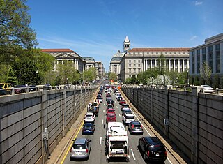
Washington, D.C. has a number of different modes of transportation available for use. Commuters have a major influence on travel patterns, with only 28% of people employed in Washington, D.C. commuting from within the city, whereas 33.5% commute from the nearby Maryland suburbs, 22.7% from Northern Virginia, and the rest from Washington, D.C.'s outlying suburbs.

The Smithsonian Institution Office of Protection Services is the guard force of the Smithsonian Institution.
Washington, D.C., is the capital city and federal district of the United States. Below is a list of Washington, D.C.-related articles.

Gail Adrienne Cobb was a Black American police officer from Washington, D.C., the first female police officer in the United States shot and killed in the line of duty. She was also the first uniformed female officer of the Metropolitan Police Department of the District of Columbia (MPDC) to have been killed in the line of duty.

The United States capital, Washington, D.C., has been the site of several events in the nation's history of aviation, beginning from the time of the American Civil War, often for the purpose of promoting the adoption of new aeronautical technologies by the government. It has also been home to several aircraft manufacturers and aviation organizations, and many aerospace contractors have maintained a presence there as well.
Potomac Gardens, known to some of its residents as "The Gardens", is a housing project located at 1225 G Street SE, in Capitol Hill, Southeast, Washington, D.C., thirteen blocks to the southeast of the United States Capitol building.
