
Fairfax, colloquially known as Fairfax Courthouse, Downtown Fairfax, or Fairfax City, and officially named the City of Fairfax, is an independent city in the Commonwealth of Virginia in the United States. As of the 2010 census the population was 22,565, which had risen to an estimated 24,013 as of 2015.
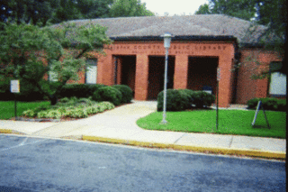
The Fairfax County Public Library (FCPL) is a public library system headquartered in Suite 324 of The Fairfax County Government Center in unincorporated Fairfax County, Virginia, United States. Hennen's American Public Library Ratings (HAPLR) has ranked the system among the top 10 libraries in the United States five times in the past 10 years.

State Route 123 is a primary state highway in the U.S. state of Virginia. The state highway runs 29.27 miles (47.11 km) from U.S. Route 1 in Woodbridge north to the Chain Bridge across the Potomac River into Washington from Arlington. It goes by three local names. From its southern terminus to the Occoquan River Bridge, it is known as Gordon Boulevard. From the Occoquan River Bridge to the city of Fairfax it is known as Ox Road. From Fairfax to its intersection with I-495 in Tysons Corner it is known as Chain Bridge Road. East of Tysons, it is known as Dolley Madison Boulevard. SR 123 is a partial circumferential highway in Northern Virginia that connects Woodbridge in eastern Prince William County with the independent city of Fairfax and the Fairfax County communities of Vienna, Tysons Corner, and McLean, the last the home of the National Counterterrorism Center and the Central Intelligence Agency. The state highway also connects all of the major highways that radiate from Washington, including Interstate 95, I-66, US 29, US 50, SR 267, and the George Washington Memorial Parkway. Furthermore, SR 123 crosses another pair of circumferential highways, I-495 and the Fairfax County Parkway, and SR 7, a major northwest–southeast highway through Northern Virginia. The state highway is a part of the National Highway System for its entire length.

Colchester is a historic unincorporated community on the Occoquan River in Fairfax County, Virginia.

Heaters is a small unincorporated community in Braxton County, West Virginia, United States. Heaters is situated about three miles north of Flatwoods on U.S. Route 19, which is a paved two-lane road. Access to I-79 is at exit 67 in Flatwoods. Heater's has a United States Postal Service post office and the ZIP Code is 26627.
Halltown is an unincorporated community on land that was originally owned by William Hall that is along Flowing Springs Run in Jefferson County, West Virginia, United States. Halltown is located off U.S. Route 340 on West Virginia Route 230 between Charles Town and Bolivar. A few houses, a fork in the road, a tiny post office, and the large Halltown Paper Plant are the distinguishing features of the community.

Colchester Hunt is an unincorporated community in Fairfax County, Virginia, United States. Colchester Hunt is located close to the town of Clifton and the independent city of Fairfax.
Woodburn is an unincorporated community in Loudoun County, Virginia. The village is located on Hogback Mountain southwest of Leesburg. Woodburn Road, which runs between Dry Mill and Harmony Church Roads, is all that is left to mark the existence and location of the community. The ruins of Woodburn's general store stood just north of the road's intersection with Forrestgrove Road until about 2000 when the Virginia Department of Transportation (VDOT), overturned the Loudoun County Board of Supervisors' decision to leave the road unpaved and paved and widened the road, demolishing the general store in the process.
Butts Corner is an unincorporated community of southern Fairfax County, Virginia, United States located at the intersection of Ox, Chapel, and Wolf Run Shoals Roads off the Fairfax County Parkway. The locale is officially inside the limits of Fairfax Station, Virginia.

Oak Hill is a suburban unincorporated community located in Fairfax County, Virginia, United States.

Mule Town is an unincorporated community in southwestern Madison Township, Scioto County, Ohio, United States. Located at the intersection of State Route 335, Lucasville-Minford Road and Bennett Road, it lies just north of the unincorporated community of Minford, 7 miles east of the census-designated place of Lucasville, and 14 miles (23 km) northeast of the city of Portsmouth, the county seat of Scioto County. Sweet Run, a tributary of the Rocky Fork of the Little Scioto River, flows past the community. Five businesses lie within Mule Town; Mule Town Mini-Mart, Foster and Fankell Garage, Bennet's Collision and Repair, Shumway Tires and the Minford Retirement Center.
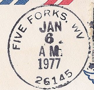
Five Forks is an unincorporated community in Calhoun County, West Virginia, United States. It lies along West Virginia Route 16 to the north of the town of Grantsville, the county seat of Calhoun County. Its elevation is 1,106 feet (337 m). The Five Forks Post Office is closed.
New Milton is an unincorporated community in central Doddridge County, West Virginia, United States. The community is located along Meathouse Fork, southeast of the town of West Union, the county seat of Doddridge County. Its elevation is 833 feet (254 m). Although it is unincorporated, it has a post office, with the ZIP code of 26411.
Beards Fork is a census-designated place (CDP) and coal town in Fayette County, West Virginia, United States that was founded as a coal town. As of the 2010 census, its population was 199.
Rutherford is an unincorporated community in Fairfax County, Virginia, United States. It lies South of Virginia State Highway 236, North of Virginia State Route 620, East of Olley Lane, and West of Guinea Road. This is west of Annandale, east of the independent city of Fairfax.
Doveville is an unincorporated community in Fairfax County, in the U.S. state of Virginia. It lies along Virginia State Highway 236, west of Annandale, east of the independent city of Fairfax and southwest of Merrifield. Immediately to the south is Rutherford and immediately to the north is Mantua. Numerous parks are located nearby, including Long Branch Stream Valley Park to the south, Daniels Run Park to the west and Woodburn Road Park and Accotink Stream Valley Park to the northeast.
Farrs Corner is an unincorporated community in Fairfax County, in the U.S. state of Virginia.

Newington Forest is a census-designated place in Fairfax County, Virginia, United States. The population as of the 2010 census was 12,442. It is part of the Washington metropolitan area. It includes the Newington Forest subdivision and several nearby neighborhoods of southern Springfield and northern Lorton.


