Odricks Corner, Virginia

Last updated
Odricks Corner, Virginia
Spring Hill REC Center.jpg
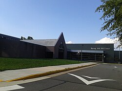
Spring Hill Recreation Center, in the approximate location of the former community of Odricks Corner, in August 2017
USA Virginia Northern location map.svg
Red pog.svg
Odricks Corner
USA Virginia location map.svg
Red pog.svg
Odricks Corner
Usa edcp location map.svg
Red pog.svg
Odricks Corner
Coordinates: 38°56′19″N77°13′53″W / 38.93861°N 77.23139°W / 38.93861; -77.23139 Coordinates: 38°56′19″N77°13′53″W / 38.93861°N 77.23139°W / 38.93861; -77.23139
Country United States
State Virginia
County Fairfax
Time zone UTC−5 (Eastern (EST))
  Summer (DST) UTC−4 (EDT)
GNIS feature ID1496042 [1]

Odricks Corner is an unincorporated community in Fairfax County, Virginia, United States. Odricks Corner lies north of the Dulles Toll Road (State Route 267) at the intersection of Spring Hill and Lewinsville Roads.

Odricks Corner takes its name from Alfred Odrick, a former slave and carpenter who in 1872 purchased 30 acres and built a house on the southern side of Lewinsville Road. This was later intersected by Spring Hill Road, and the resulting location came to be known as Odrick's Corner. By 1879 a one-room schoolhouse, called Odrick's School, had been erected at the corner; tradition links Alfred Odrick to its creation. The school came to be used as well as a location for community meetings, and was the first place where services for Shiloh Baptist Church were held. The original frame building, which came to be the center of a thriving African-American community, was eventually replaced with a brick structure. This was later closed, and was sold in 1953; it has since been demolished. [2]

The history of the community has been noted by a historic marker near the Spring Hill Recreation Center, erected by the Fairfax County History Commission in 2002. [3]

Related Research Articles

Fairfax County, Virginia County in Virginia

Fairfax County, officially the County of Fairfax, is located in the Commonwealth of Virginia in the United States. Part of Northern Virginia, Fairfax County borders both the City of Alexandria and Arlington County and forms part of the suburban ring of Washington, D.C. The county is thus predominantly suburban in character, with some urban and rural pockets.

Fairfax, Virginia Independent city in Virginia, United States

The City of Fairfax, colloquially known as Fairfax City, Downtown Fairfax, Old Town Fairfax, Fairfax Courthouse, or simply Fairfax, is an independent city in the Commonwealth of Virginia in the United States. As of the 2010 census the population was 22,565, which had risen to an estimated 24,019 as of 2019.

Annandale, Virginia Census-designated place in Virginia

Annandale is a census-designated place (CDP) in Fairfax County, Virginia. The population of the CDP was 41,008 as of the 2010 United States Census. It is home to the oldest and largest branch of the Northern Virginia Community College system, and to one of the D.C. area's Koreatowns.

Baileys Crossroads, Virginia Census-designated place in Virginia, United States

Bailey's Crossroads is a census-designated place (CDP) in Fairfax County, Virginia, United States. The population was 23,643 at the 2010 census. Bailey's Crossroads lies at the "crossroads" of State Route 7 and State Route 244.

Burke, Virginia Census-designated place in Virginia

Burke is an unincorporated section of Fairfax County, Virginia, United States traditionally defined as the area served by the Burke post office. Burke includes two census-designated places: The Burke CDP, population 41,055 in 2010 and the Burke Centre CDP, population 17,326.

Franconia, Virginia Census-designated place in Virginia, United States

Franconia is a census-designated place (CDP) in Fairfax County, Virginia, United States. The population was 18,245 at the 2010 census, down from 31,907 in 2000 due to the splitting off of part of it to form the Kingstowne CDP.

McLean, Virginia Census-designated place and unincorporated community in Virginia

McLean is an unincorporated community and census-designated place (CDP) in Fairfax County in Northern Virginia. McLean is home to many diplomats, military, members of Congress, and high-ranking government officials partially due to its proximity to Washington, D.C., The Pentagon and the Central Intelligence Agency. It is the location of Hickory Hill, the former home of Ethel Kennedy, the widow of Robert F. Kennedy. It is also the location of Salona, the former home of Light-Horse Harry Lee, the Revolutionary War hero. The community had an estimated total population of 53,673 in 2015, according to estimates prepared by the United States Census Bureau. It is located between the Potomac River and the town of Vienna. McLean is often distinguished by its luxury homes and its nearby high-profit shopping destinations: Tysons Corner Center and Tysons Galleria. The two McLean zip codes – 22101 and 22102 – are among the most expensive ZIP Codes in Virginia and the United States. In 2018, data from the American Community Survey revealed that McLean was the 3rd wealthiest city in the United States, based on its poverty rate of 2.6% and its median household income of $190,258.

Reston, Virginia Place in Virginia, United States

Reston is a census-designated place in Fairfax County, Virginia. Founded in 1964, Reston was influenced by the Garden City movement that emphasized planned, self-contained communities that intermingled green space, residential neighborhoods, and commercial development. The intent of Reston's founder, Robert E. Simon, was to build a town that would revolutionize post–World War II concepts of land use and residential/corporate development in suburban America. In 2018, Reston was ranked as the Best Place to Live in Virginia by Money magazine for its expanses of parks, lakes, golf courses, and bridle paths as well as the numerous shopping and dining opportunities in Reston Town Center.

Rose Hill, Fairfax County, Virginia Census-designated place in Virginia, United States

Rose Hill is a census-designated place (CDP) in Fairfax County, Virginia, United States. The population was 20,226 at the 2010 census. Built in the mid-1950s, Rose Hill is the largest of the subdivisions that make up the CDP, which is just southwest of Alexandria; others include Wilton Woods, Burgundy Village, and Winslow Heights. Street addresses are in Alexandria ZIP codes 22310, 22303 and 22315.

Springfield, Virginia Census-designated place in Virginia, United States

Springfield is a census-designated place (CDP) in Fairfax County, Virginia, United States. The Springfield CDP is recognized by the U.S. Census Bureau with a population of 30,484 as of the 2010 census. Homes and businesses in bordering CDPs including North Springfield, West Springfield, and Newington are usually given a Springfield mailing address. The population of the collective areas with Springfield addresses is estimated to exceed 100,000. The CDP is a part of Northern Virginia, the most populous region of the Washington Metropolitan Area.

Tysons, Virginia Census-designated place in Virginia, United States

Tysons, also known as Tysons Corner, is a census-designated place (CDP) and unincorporated community in Fairfax County, Virginia, United States. Located in Northern Virginia between the community of McLean and the town of Vienna along the Capital Beltway (I-495), it lies within the Washington Metropolitan Area. Tysons is home to two super-regional shopping malls—Tysons Corner Center and Tysons Galleria—and the corporate headquarters of numerous companies such as Intelsat, DXC Technology, Gannett, Hilton Worldwide, Freddie Mac, Capital One, and Booz Allen Hamilton. Tysons is Fairfax County's central business district and a regional commercial center. It has been characterized as a quintessential example of an edge city. The population was 19,627 as of the 2010 census.

Vienna, Virginia Town in Virginia, United States

Vienna is a town in Fairfax County, Virginia, United States. As of the 2010 United States Census, it had a population of 15,687. Significantly more people live in ZIP codes with the Vienna postal addresses, bordered approximately by Interstate 66 on the south, Interstate 495 on the east, Route 7 to the north, and Hunter Mill Road to the west, than in the town itself.

Ballston, Arlington, Virginia Neighborhood in Arlington, Virginia

Ballston is a neighborhood in Arlington County, Virginia and is home to the Ballston-MU station on the Orange Line and the Silver Line of the metro system. Located at the western end of the Rosslyn-Ballston corridor, Ballston is a major transportation hub and boasts one of the nation's highest concentrations of scientific research agencies, including the Office of Naval Research, the Virginia Tech Advanced Research Institute and the Air Force Office of Scientific Research.

Virginia State Route 620 (Fairfax and Loudoun Counties) Highway in Virginia

State Route 620 in Fairfax and Loudoun Counties, Virginia is a secondary state highway. The entire length of SR 620 is also known as Braddock Road. SR 620 also has a short concurrency with SR 659 / Union Mill Road in Centreville.

Fairfax County Public Schools

The Fairfax County Public Schools system is a school division in the U.S. commonwealth of Virginia. It is a branch of the Fairfax County government which administers public schools in Fairfax County and the City of Fairfax. FCPS's headquarters is located in the Gatehouse Administration Center in Merrifield, an unincorporated section of the county near the city of Falls Church; the headquarters has a Falls Church address but is not within the city limits.

Ox Hill Battlefield Park

Ox Hill Battlefield Park is a site in Fairfax, Virginia, where the Battle of Ox Hill was fought during the American Civil War. It was the only major battle of the war fought in Fairfax County. The battlefield is now a public park adjacent to suburban developments and the Fairfax Towne Center shopping center, and is maintained by the Fairfax County Park Authority.

Virginia State Route 123 State highway in Virginia, United States

State Route 123 is a primary state highway in the U.S. state of Virginia. The state highway runs 29.27 miles (47.11 km) from U.S. Route 1 in Woodbridge north to the Chain Bridge across the Potomac River into Washington from Arlington. It goes by four local names. From its southern terminus to the Occoquan River Bridge, it is known as Gordon Boulevard. From the Occoquan River Bridge to the city of Fairfax it is known as Ox Road. From Fairfax until it enters the Town of Vienna, it is known as Chain Bridge Road. Then, as it passes through the Town of Vienna, it is known as Maple Avenue. After leaving the Town of Vienna, the name reverts to Chain Bridge Road, and continues this way until the intersection with I-495 in Tysons Corner. Between Tysons and the George Washington Memorial Parkway, it is known as Dolley Madison Boulevard. After crossing over the George Washington Memorial Parkway, the name once again reverts to Chain Bridge Road and continues this way until the end of the road, at Chain Bridge. SR 123 is a partial circumferential highway in Northern Virginia that connects Woodbridge in eastern Prince William County with the independent city of Fairfax and the Fairfax County communities of Vienna, Tysons Corner, and McLean, the last being the home of the National Counterterrorism Center and the Central Intelligence Agency. The state highway also connects all of the major highways that radiate from Washington, including Interstate 95, I-66, US 29, US 50, SR 267, and the George Washington Memorial Parkway. Furthermore, SR 123 crosses another pair of circumferential highways, I-495 and the Fairfax County Parkway, and SR 7, a major northwest–southeast highway through Northern Virginia. The state highway is a part of the National Highway System for its entire length.

Slanesville, West Virginia Unincorporated community in West Virginia, United States

Slanesville is an unincorporated community in northeastern Hampshire County in the U.S. state of West Virginia. Slanesville is located at the crossroads of Bloomery Pike with Slanesville Pike and Cold Stream Road. Slanesville Pike and Cold Stream Road formerly made up the Springfield Grade Road that ran from Capon Bridge to Springfield. According to the 2000 census, the Slanesville community has a population of 691.

Historic Fairfax County Courthouse United States historic place

The Historic Fairfax County Courthouse is one of the oldest buildings in Fairfax, Virginia. It was constructed in 1799 to serve as the seat of government in Fairfax County. During the American Civil War, the first Confederate officer casualty of the war took place on the courthouse grounds and the building was occupied by both sides in the conflict. Today, the original courthouse building is part of the larger courthouse site that serves the local government of Fairfax County.

References

  1. U.S. Geological Survey Geographic Names Information System: Odricks Corner, Virginia
  2. "Odrick's Corner Historical Marker" . Retrieved 2 April 2017.
  3. "Odrick's Corner Recognized after 130 Years" . Retrieved 2 April 2017.