
Rappahannock County is a county located in the northern Piedmont region of the Commonwealth of Virginia, US, adjacent to Shenandoah National Park. As of the 2020 Census, the population was 7,348. Its county seat is Washington. The name "Rappahannock" comes from the Algonquian word lappihanne, meaning "river of quick, rising water" or "where the tide ebbs and flows." The county is included in the Washington-Arlington-Alexandria, DC-VA-MD-WV Metropolitan Statistical Area.
Middlesex County is a county located on the Middle Peninsula in the U.S. state of Virginia. As of the 2010 census, the population was 10,625. Its county seat is Saluda.

Caroline County is a United States county located in the eastern part of the Commonwealth of Virginia. The northern boundary of the county borders on the Rappahannock River, notably at the historic town of Port Royal. The Caroline county seat is Bowling Green.
Round Hill is a town in Loudoun County, Virginia, United States. Its population was 539 at the 2010 census and an estimated 656 in 2019. The town is located at the crossroads of Virginia Routes 7 and 719, approximately 50 miles (80 km) northwest of Washington, D.C. The town's name refers a hill two miles northeast of a 910-foot (280 m) hill used during the American Civil War as a signal post by both Confederate and Union troops.

The town of Washington, Virginia, is a historic village located in the eastern foothills of the Blue Ridge Mountains near Shenandoah National Park. The entire town is listed on the National Register of Historic Places as a historic district, Washington Historic District. It is the county seat of Rappahannock County, Virginia.

Falmouth is a census-designated place (CDP) in Stafford County, Virginia, United States. Situated on the north bank of the Rappahannock River at the falls, the community is north of and opposite the city of Fredericksburg. Recognized by the U.S. Census Bureau as a census-designated place (CDP), Falmouth's population was 4,274 as of the 2010 census.
U.S. Route 522 is a spur route of US 22 in the states of Virginia, West Virginia, Maryland, and Pennsylvania. The U.S. Highway travels in a north-south direction, and runs 308.59 miles (496.63 km) from US 60 near Powhatan, Virginia, to its northern terminus at US 11 and US 15 near Selinsgrove, Pennsylvania. US 522 serves many small cities and towns in the Piedmont, Blue Ridge Mountains, and northern Shenandoah Valley of Virginia. The highway serves the Virginia communities of Goochland, Mineral, Culpeper, the town of Washington, and Front Royal and the independent city of Winchester. US 522 then follows the Ridge-and-Valley Appalachians north and then east through the Eastern Panhandle of West Virginia, a 2-mile-wide (3.2 km) stretch of Western Maryland, and South Central Pennsylvania to its terminus in the Susquehanna Valley. The highway serves Berkeley Springs, West Virginia; Hancock, Maryland; and the Pennsylvania communities of McConnellsburg, Mount Union, Lewistown, and Middleburg.

Marshall is a census-designated place (CDP) and unincorporated town in northwestern Fauquier County, Virginia, in the United States. The population as of the 2010 census was 1,480.
Prices Fork is a small traditionally agricultural census-designated place (CDP), in Montgomery County, Virginia, United States. The population as of the 2010 Census was 1,066. It is located about three miles west of Blacksburg and the campus of Virginia Polytechnic Institute and State University.

Sperryville is a census-designated place (CDP) located in the western section of Rappahannock County, Virginia, United States, near Shenandoah National Park. It consists of a village with two main streets along the two branches of the Thornton River, together with surrounding pasture- and farmland. The population as of the 2010 Census was 342.

Bristow is an unincorporated community of Prince William County in Northern Virginia about 30 miles (48 km) from Washington, D.C. In 2014, Bristow's postal area population was 29,346, a 287% increase since 2000; however, the Bristow community is formally included in the Linton Hall, Virginia census-designated place (CDP).

Falls Village is a village and census-designated place in the town of Canaan in Litchfield County, Connecticut, United States. As of the 2010 census it had a population of 538, out of 1,234 in the entire town of Canaan. Because Falls Village is the town center and principal constituent village in Canaan, the entire town is often referred to as "Falls Village". That usage also avoids confusion of the town with Canaan Village in the town of North Canaan, Connecticut, not far away. Falls Village derives its name from a waterfall, known as Great Falls, on the Housatonic River within the village.

Palmyra is a census-designated place (CDP) in and the county seat of Fluvanna County, Virginia, United States. The population as of the 2010 census was 104. Palmyra lies on the eastern bank of the Rivanna River along U.S. Route 15. The ZIP code for Palmyra and surrounding rural land is 22963.

New Baltimore is an unincorporated community and census-designated place (CDP) in eastern Fauquier County, Virginia, United States. The population as of the 2010 census was 8,119. The community has existed since the early 19th century, but it has had its most significant growth since the 1980s. It is the portion of Fauquier County with the easiest access to Washington, D.C., and as a result, many people who live in New Baltimore commute into DC. Other major communities close to New Baltimore are Warrenton, Gainesville/Haymarket area, and Manassas. The area officially considered to be New Baltimore expanded significantly in 2006 with Fauquier County's designation of service districts, of which New Baltimore is one. The service district designation provides added access to utilities such as water and sewer, and targets the area for growth.

Laurel Mills is an unincorporated community in Rappahannock County, Virginia, United States. It is located in the southern part of the county, approximately halfway between Amissville and Washington. Laurel Mills is located along the Thornton River in Rappahannock County on Route 618, between Viewtown and Rock Mills.
Founded in 1886, Weems is an unincorporated community and census-designated place (CDP) in Lancaster County in the U. S. state of Virginia. It was first drawn as a CDP prior to the 2020 census.

Finesville is an unincorporated community and census-designated place (CDP) located within Pohatcong Township in Warren County, New Jersey, United States, that was defined as part of the 2010 United States Census. As of the 2010 Census, the CDP's population was 175.
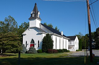
Flint Hill Baptist Church is a historic Southern Baptist church in Flint Hill, Rappahannock County, Virginia. The original section was built in 1854 and expanded and remodeled in the 1890s in the Late Victorian style. The original section is a one-story, gable-roofed, frame-and-weatherboard rectangular structure. Later additions are the front entrance tower topped with a belfry and Sunday school rooms to the rear. It features six stained-glass windows. Also on the property is the contributing church cemetery. Among those buried in the churchyard is Confederate Private Albert Gallatin Willis, one of Mosby's Rangers and a seminarian who offered himself for execution in the place of a married comrade-in-arms; the grave is noted with a marker in the Civil War Trails series.

The Ben Venue Rural Historic District encompasses a large rural historic landscape in northeastern Rappahannock County, Virginia. It is centered on Ben Venue Road, between United States Route 211 in the south and the village of Flint Hill in the north, and encompasses more than 2,600 acres (1,100 ha) of rural landscape, affording fine panoramic views of the Blue Ridge Mountains to the west. This area was developed agriculturally beginning in the mid-18th century by wealthy Virginia families, around what was one of the region's first turnpikes, and has maintained its rural character in the intervening centuries. Prominent properties in the district include the 1844 Ben Venue estate and the 1773 Battle Run Primitive Baptist Church.


