
Rappahannock County is a county located in the northern Piedmont region of the Commonwealth of Virginia, US, adjacent to Shenandoah National Park. As of the 2020 Census, the population was 7,348. Its county seat is Washington. The name "Rappahannock" comes from the Algonquian word lappihanne, meaning "river of quick, rising water" or "where the tide ebbs and flows." The county is included in the Washington-Arlington-Alexandria, DC-VA-MD-WV Metropolitan Statistical Area.

Shadwell is a census-designated place (CDP) in Albemarle County, Virginia. It is located by the Rivanna River near Charlottesville. The site today is marked by a Virginia Historical Marker to mark the birthplace of President Thomas Jefferson. It is listed on the National Register of Historic Places along with Clifton.

Sperryville is a census-designated place (CDP) located in the western section of Rappahannock County, Virginia, United States, near Shenandoah National Park. It consists of a village with two main streets along the two branches of the Thornton River, together with surrounding pasture- and farmland. The population as of the 2010 Census was 342.

Moore State Park is a 737-acre (298 ha) public recreation area located in the town of Paxton, Massachusetts, USA, portions of which were listed on the National Register of Historic Places as the Moore State Park Historic District in 2004. Features of the state park include historical building foundations, a restored sawmill, Eames Pond, waterfalls and mill chutes as well as abundant azaleas, rhododendrons, and mountain laurel. The park is managed by the Massachusetts Department of Conservation and Recreation.

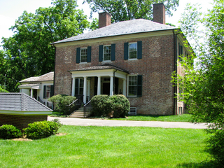
The Jarrell Plantation State Historic Site is a former cotton plantation and state historic site in Juliette, Georgia, United States. Founded as a forced-labor farm worked by John Jarrell and the African American people he enslaved, the site stands today as one of the best-preserved examples of a "middle class" Southern plantation. The Jarrell Plantation's buildings and artifacts all came from the Jarrell family, who farmed the land for over 140 years. Located in the red clay hills of the Georgia piedmont, It was added to the National Register of Historic Places in 1973. It is a Georgia state park in Jones County.

Flint Hill is a census-designated place (CDP) in Rappahannock County, Virginia, United States. The population as of the 2010 Census was 209. It is located on Route 522, approximately 2 miles to the east of the border of the Shenandoah National Park.

Statesview, or States View, is a historic house located on South Peters Road off Kingston Pike in Knoxville, Tennessee, United States. Built in 1805 by early Knoxville architect Thomas Hope and rebuilt in 1823 following a fire, Statesview was originally the home of surveyor Charles McClung (1761–1835). Following McClung's death, newspaper publisher Frederick Heiskell (1786–1882) purchased the house and estate, which he renamed "Fruit Hill." The house is listed on the National Register of Historic Places for its architecture and political significance.

Bremo, also known as Bremo Plantation or Bremo Historic District, is a plantation estate covering over 1,500 acres (610 ha) on the west side of Bremo Bluff in Fluvanna County, Virginia. The plantation includes three separate estates, all created in the 19th century by the planter, soldier, and reformer John Hartwell Cocke on his family's 1725 land grant. The large neo-palladian mansion at "Upper" Bremo was designed by Cocke in consultation with John Neilson, a master joiner for Thomas Jefferson's Monticello. The Historic District also includes two smaller residences known as Lower Bremo and Bremo Recess.

The Gurleyville Historic District encompasses a formerly industrial rural crossroads village in Mansfield, Connecticut. Centered on Gurleyville and Chaffeeville Roads, it includes a collection of mainly vernacular 19th-century residences, a stone gristmill dating to about 1749, and the archaeological remains of later industrial endeavours. The district was listed on the National Register of Historic Places in 1975.

The Hotchkissville Historic District is a historic district in the town of Woodbury, Connecticut, that was listed on the National Register of Historic Places in 1995. The district encompasses most of the historic village of Hotchkissville, which is centered at the junction of Washington and Weekeepeemee roads. The village began as a dispersed rural agricultural community, but developed in the 19th century with the arrival of industry, primarily the manufacture of textiles. Despite this, the village has retained a significantly rural character, and includes a broad cross-section of 18th- and 19th-century architectural styles.
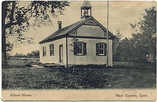
The West Goshen Historic District is a historic district in the village of West Goshen in the town of Goshen, Connecticut. It encompasses a well-preserved early 19th-century industrial village, with twenty historically significant properties in the village, most of which lie on Connecticut Route 4 between Beach Street and Thompson Road. The district was listed on the National Register of Historic Places in 1987.

Lemon Hill is a Federal-style mansion in Fairmount Park, Philadelphia, built from 1799 to 1800 by Philadelphia merchant Henry Pratt. The house is named after the citrus fruits that Pratt cultivated on the property in the early 19th century.

Corotoman was a 17th and 18th century plantation on the Rappahannock River in Lancaster County, Virginia, United States. Corotoman was the residence of Robert Carter I, a colonial Governor of Virginia and one of the wealthiest men in the British colonies in North America. Corotoman was located on a point overlooking the Rappahannock River, and flanked by Carter's Creek and Corrotoman River to its east and west respectively.
Oak Hill in Annandale, Virginia, United States, is a Georgian style home built in 1790. It was listed on the National Register of Historic Places in 2004.
Bruyn Estate at Red Mills Farm or "Miller's House at Red Mills Farm" is a historic estate and farm located in Shawangunk in Ulster County, New York. Situated on just under 25 acres, Bruyn Estate has two residential dwellings totaling eight bedrooms. One 1835 Greek Revival farmhouse (3BR) on the National Register, and one newly built Log Home made from salvaged, antique 1850s barns, surrounded by landscaped lawns and outdoor event spaces. It is on the east side of the Shawangunk Kill at the Ulster/Orange Counties line. Wallkill Avenue is north of the building with the Shawangunk Kill east of it.
The Rapidan Dam Canal of the Rappahannock Navigation is a canal intended to safely carry Batteaus, sturdy flat-bottomed boats used primarily for transporting cargo, around the rapids at the confluence of the Rappahannock and Rapidan Rivers. The Rapidan Canal, funded and constructed by The Rappahannock Company, consists of two different canals built at different times. All of the Rappahannock Navigation, of which the Rapidan Canal is a part, is located in the Piedmont region of Virginia. The Confluence, the name used on maps of the day and sometimes maps of today to denote where the two rivers meet, is located where the borders of the Virginia Counties of Spotsylvania, Stafford and Culpeper meet but is owned by the City of Fredericksburg, Virginia. The Rapidan Canal was listed on the Virginia Landmarks Register (VLR) on June 19, 1973, and on the National Register of Historic Places on July 26, 1973.
Fall Hill is a plantation located near the falls on the Rappahannock River in Fredericksburg, Virginia. Though the Thornton family has lived at Fall Hill since the early 18th century, the present house was built in 1790 for Francis Thornton V (1760–1836). The land on which Fall Hill is located is part of an 8,000 acres (3,200 ha) land patent obtained by Francis Thornton I (1657–1727) around 1720. The present-day town of Fredericksburg, Virginia is located on that original patent.

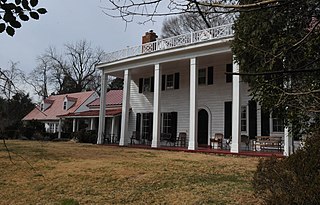
Powhatan Rural Historic District, formerly "Powhatan Hill Plantation" and before that "Hopyard Plantation", is a national historic district located near King George, King George County, Virginia. It encompasses 15 contributing buildings, 1 contributing site, and 3 contributing structures in a rural area near King George. The district represents a significant reassemblage of the land holdings of Edward Thornton Tayloe, a member of the U.S. diplomatic service under Joel Roberts Poinsett, in the mid-19th century and one of Virginia's most affluent planters of that era; who inherited it from his father John Tayloe III, who built The Octagon House in Washington DC, and it was known then as 'Hopyard,' he inherited it from his father John Tayloe II who built the grand colonial estate Mount Airy. It contains three distinct historic residential farm clusters as well as two post-1950 stable complexes and several other auxiliary residential and agricultural buildings. The main house, known as Powhatan, is sited prominently on a ridge overlooking the Rappahannock River valley.

Laurel Mills Historic District is a national historic district located at Laurel Mills, Rappahannock County, Virginia. It encompasses 10 contributing buildings, 1 contributing site, and 1 contributing object in the village of Laurel Mills. It includes a collection of domestic and commercial buildings that primarily developed in response to a growing mill industry. The buildings primarily date from the 1840s to the early 1900s. Laurel Mills appears today much as it did when the mill closed in 1927.

The Bridgewater Woolen Mill, now more commonly the Bridgewater Mill Mall, is a historic textile mill complex on United States Route 4 in Bridgewater and Woodstock, Vermont. With an textile processing history dating from 1828 to 1975, it was one of the state's longest-lived textile operations, and was a mainstay of the local economy during that period. It has since been repurposed into a shopping center. It was listed on the National Register of Historic Places in 1976.


