
Gettysburg is a borough in Pennsylvania and the county seat of Adams County, Pennsylvania, United States. As of the 2020 census, the borough had a population of 7,106 people.

Forks, also previously known as the unincorporated town of Quillayute, is a city in southwest Clallam County, Washington, United States. The population was 3,335 at the 2020 census. It is named after the forks in the nearby Bogachiel, Calawah, and Sol Duc rivers which join to form the Quillayute River.

The Olympic Peninsula is a large arm of land in western Washington that lies across Puget Sound from Seattle, and contains Olympic National Park. It is bounded on the west by the Pacific Ocean, the north by the Strait of Juan de Fuca, and the east by Hood Canal. Cape Alava, the westernmost point in the contiguous United States, and Cape Flattery, the northwesternmost point, are on the peninsula. Comprising about 3,600 square miles (9,300 km2), the Olympic Peninsula contained many of the last unexplored places in the contiguous United States. It remained largely unmapped until Arthur Dodwell and Theodore Rixon mapped most of its topography and timber resources between 1898 and 1900.

State Route 113 (SR 113), also known as Burnt Mountain Road, is a Washington state highway in Clallam County on the Olympic Peninsula. It connects U.S. Route 101 (US 101) at Sappho to SR 112 near Clallam Bay, traveling north along Beaver Creek and the Pysht River for 10 miles (16 km).

State Route 112 is a state highway and scenic byway in the U.S. state of Washington. It runs east–west for 61 miles (98 km) along the Strait of Juan de Fuca in Clallam County, connecting the Makah Indian Reservation near Neah Bay to U.S. Route 101 (US 101) near Port Angeles.
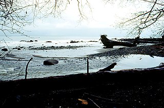
Clallam Bay is an unincorporated community and census-designated place (CDP) in Clallam County, Washington, United States, at the mouth of the Clallam River into Clallam Bay. Known for its natural environment and hunting, Clallam Bay is partially reliant on tourism. Clallam Bay is considered the twin city of nearby Sekiu. As of the 2020 census, the population of Clallam Bay was 386, up from 363 at 2010.

Lake Crescent is a deep lake located entirely within Olympic National Park in Clallam County, Washington, United States, approximately 17 miles (27 km) west of Port Angeles on U.S. Route 101, near the small community of Piedmont. With an official maximum depth of 624 feet (190 m), it is officially the second deepest lake in the state of Washington. A lake-wide bathymetric survey was performed from 2013 to 2014 by Eian Ray and Jeff Engea and the results of this survey show the maximum depth as being 596 feet (182 m). Using GIS statistical analysis, this survey also estimated that the lake contains around 0.5 cubic miles (2.1 km3) of fresh water.

Sappho is an unincorporated community in Clallam County, Washington, United States. The town is located at the intersection of U.S. Route 101 and State Route 113, in a largely forested area, and features parks and recreational facilities.

Lester is a ghost town near Stampede Pass, just south of Snoqualmie Pass in King County, founded in 1892 by the Northern Pacific Railway. Lester is located along what is currently National Forest Development Road 54, on land owned by Tacoma Water, a division of Tacoma Public Utilities.

The Lyre River in the U.S. state of Washington flows out of Lake Crescent in the Olympic National Park and into the Strait of Juan de Fuca. Originally referred to as "singing waters" by the Indians living near it, the river was first named Rio de Cuesta by Europeans in 1790 by Gonzalo López de Haro, but was later called River Lyre after being charted by Captain Henry Kellett in 1847.

Almota is a ghost town in Whitman County, in the U.S. state of Washington. The GNIS classifies it as a populated place.

Barneston is an extinct town in King County, in the U.S. state of Washington. The GNIS classifies it as a populated place.
Edgewick is an unincorporated community in King County, in the U.S. state of Washington.
Jameson is an ghost town in Douglas County, in the U.S. state of Washington.
Port Williams is an unincorporated community in Clallam County, in the U.S. state of Washington.
Rena is an unincorporated community in Clallam County, in the U.S. state of Washington.
Rodna is an extinct town in Spokane County, in the U.S. state of Washington. The GNIS classifies it as a populated place.
Silcott is an unincorporated community and ghost town in Asotin County, in the U.S. state of Washington. It is located on the south bank of the Snake River. U.S. Route 12 passes through the community. Much of the townsite was inundated when Lower Granite Lake filled on the Snake River behind Lower Granite Dam in 1975.
Swofford, also known as Swofford Valley, is an unincorporated community in central Lewis County, in the U.S. state of Washington. The town sits on the south shore of Riffe Lake, approximately 4.0 miles (6.4 km) southeast of Mossyrock.

Taylor is a ghost town in King County, in the U.S. state of Washington.


