Contra Costa County is a county located in the U.S. state of California, in the East Bay of the San Francisco Bay Area. As of the 2020 United States Census, the population was 1,165,927. The county seat is Martinez. It occupies the northern portion of the East Bay region of the San Francisco Bay Area and is primarily suburban. The county's name refers to its position on the other side of the bay from San Francisco. Contra Costa County is included in the San Francisco–Oakland–Berkeley, CA Metropolitan Statistical Area.

San Mateo County, officially the County of San Mateo, is a county located in the U.S. state of California. As of the 2020 census, the population was 764,442. Redwood City is the county seat, and the third most populated city following Daly City and San Mateo. San Mateo County is included in the San Francisco–Oakland–Berkeley, CA MSA, Silicon Valley, and is part of the San Francisco Bay Area, the nine counties bordering San Francisco Bay. It covers most of the San Francisco Peninsula. San Francisco International Airport is located in the northeastern area of the county and is approximately 7 miles (11 km) south of the city and county limits of San Francisco, even though the airport itself is assigned a San Francisco postal address. The county's built-up areas are mostly suburban, and are home to several corporate campuses.

York County is a county in the eastern part of the Commonwealth of Virginia, located in the Tidewater. As of the 2020 census, the population was 70,045. The county seat is the unincorporated town of Yorktown.
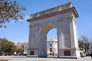
Newport News is an independent city in the Commonwealth of Virginia in the United States. At the 2020 census, the population was 186,247. Located in the Hampton Roads region, it is the fifth-most populous city in Virginia and 140th-most populous city in the United States.

Soldotna is a city in the Kenai Peninsula Borough in the U.S. state of Alaska. At the 2020 census, the population was 4,342, up from 4,163 in 2010. It is the seat of the Kenai Peninsula Borough.
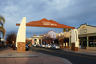
Brentwood, or “Corn Town”, is a city in Contra Costa County, California, United States. It is located in the East Bay region of the San Francisco Bay Area. The population is 66,854 as of 2022, an increase of 287% from 23,302 at the 2000 census.

South San Francisco is a city in San Mateo County, California, United States, located on the San Francisco Peninsula in the San Francisco Bay Area. The city is colloquially known as "South City". The population was 66,105 at the 2020 census.

Beaufort is a city in and the county seat of Beaufort County, South Carolina, United States. Chartered in 1711, it is the second-oldest city in South Carolina, behind Charleston, which was established in 1670. A city rich in history, culture, southern hospitality, and a seaside charm, Beaufort is affectionately known as the "Queen of the Carolina Sea Islands". The city's population was 13,607 at the 2020 census. It is part of the Hilton Head Island–Bluffton metropolitan area.

Pleasant Prairie is a village in the U.S. state of Wisconsin. Located in Kenosha County along the southwestern shoreline of Lake Michigan, Pleasant Prairie was home to 21,250 people at the 2020 census. The village is positioned directly south of the city of Kenosha and directly north of the Illinois border. Although located just 37 miles south of Milwaukee, it is part of the United States Census Bureau's Chicago combined statistical area (CSA) and metropolitan statistical area despite being 57 miles north of that city. Among its notable features are the RecPlex and Chiwaukee Prairie.

Traverse City is a city in the U.S. state of Michigan. It is the county seat of Grand Traverse County, although a small portion extends into Leelanau County. It is the largest city in the 21-county Northern Michigan region. The population was 15,678 at the 2020 census, with 153,448 in the four-county Traverse City micropolitan area. Traverse City is also the second-largest city in Michigan north of the Tri-Cities, behind Marquette.

Wiarton is a community in the town of South Bruce Peninsula, Bruce County, Ontario, Canada. It is located at the western end of Colpoys Bay, an inlet off Georgian Bay, on the Bruce Peninsula.
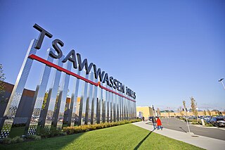
Tsawwassen is a suburban, mostly residential community on a peninsula in the southwestern corner of the City of Delta in British Columbia, Canada. It provides the only road access to the American territory on the southern tip of the peninsula, the community of Point Roberts, Washington, via 56th Street. It is also the location of Tsawwassen Ferry Terminal, part of the BC Ferries, built in 1959 to provide foot-passenger and motor vehicle access from the Lower Mainland to the southern part of Vancouver Island and the southern Gulf Islands. Because Tsawwassen touches a shallow bank, the ferry terminal is built at the southwestern end of a 3 km (1.9 mi) causeway that juts into the Strait of Georgia. Boundary Bay Airport, a major training hub for local and international pilots which also provides local airplane and helicopter service, is ten minutes away. The Roberts Bank Superport is also nearby.
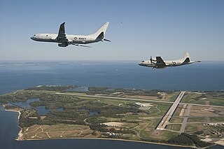
Naval Air Station Patuxent River, also known as NAS Pax River, is a United States naval air station located in St. Mary’s County, Maryland, on the Chesapeake Bay near the mouth of the Patuxent River.

Discovery Bay is a small bay connected to the Strait of Juan de Fuca on the coast of the Olympic Peninsula in Washington state; it was also historically called Port Discovery. An unincorporated community also named Discovery Bay lies in Jefferson County at the southern end of the bay.
Gardiner is an unincorporated community in Jefferson County, Washington, United States. Additionally, part of Clallam County, located along the Jefferson County line adjacent to Gardiner is often referred to as being part of Gardiner.

Curtis Bay is a residential / commercial / industrial neighborhood in the southern portion of the City of Baltimore, Maryland, United States.
The St. Joe Company is a land development company headquartered in Panama City Beach, Florida. Founded in 1936 and until 1966 known as St. Joe Paper Company, the company still operates a forestry division but is primarily engaged in real estate development and asset management. The company's land holdings are concentrated in Northwest Florida with the vast majority located in Bay and Walton counties. Of the 110,500 acres The St. Joe Company owns that fall within the Bay-Walton Sector Plan, 53,000 acres were placed into conservation by the company. The company develops its land for a variety of uses including residential neighborhoods, hotels, apartment communities, leasable commercial space, office buildings and medical facilities among others.

Hawkins Point is a neighborhood in the South District of Baltimore, located at the southern tip of the city between Curtis Bay (north) and the Anne Arundel County line (south) and Thoms Cove (east). Its land area covers 2.6 square miles (6.7 km2), and it had a population of 24 people according to the 2020 U.S. Census. The neighborhood is predominantly industrial.

Cape Pallarenda Quarantine Station is a heritage-listed former quarantine station at 1 The Esplanade, Pallarenda, City of Townsville, Queensland, Australia. It was built from 1915 to 1916. It is also known as Northern Regional Office, Department of Environment and Resource Management, Northern Regional Office, Environmental Protection Agency, and Cape Pallarenda Coastal Battery. It was added to the Queensland Heritage Register on 23 April 1999. The building is part of Cape Pallarenda Conservation Park.

Brewer Island is an island in the San Francisco Bay, in San Mateo County, California. Originally owned by W. P. A. Brewer, for over one hundred years it was used for hay farming. Several attempts to develop the island failed between 1912 and 1959. Ultimately, a venture by Richard Grant and T. Jack Foster succeeded in 1960; Brewer Island's surface was raised by 6 ft (1.8 m), an artificial lake was dug in its center, and it became the location of what is now known as Foster City.