Clallam County is a county in the U.S. state of Washington. As of the 2020 census, the population was 77,155, with an estimated population of 77,805 in 2022. The county seat and largest city is Port Angeles; the county as a whole comprises the Port Angeles, WA Micropolitan Statistical Area. The name is a Klallam word for "the strong people". The county was formed on April 26, 1854. Located on the Olympic Peninsula, it is south from the Strait of Juan de Fuca, which forms the Canada–US border, as British Columbia's Vancouver Island is across the strait.
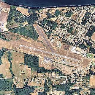
William R. Fairchild International Airport is a public airport located within the city limits of Port Angeles in Clallam County, Washington, United States. It is 3.5 miles northwest of the central business district of Port Angeles, near the Strait of Juan de Fuca. The airport is owned by the Port of Port Angeles.

State Route 113 (SR 113), also known as Burnt Mountain Road, is a Washington state highway in Clallam County on the Olympic Peninsula. It connects U.S. Route 101 (US 101) at Sappho to SR 112 near Clallam Bay, traveling north along Beaver Creek and the Pysht River for 10 miles (16 km).
Clallam Bay is an unincorporated community and census-designated place (CDP) in Clallam County, Washington, United States, at the mouth of the Clallam River into Clallam Bay. Known for its natural environment and hunting, Clallam Bay is partially reliant on tourism. Clallam Bay is considered the twin city of nearby Sekiu. As of the 2010 census, the population of Clallam Bay was 363.
Jamestown is an unincorporated community and census-designated place (CDP) in Clallam County, Washington, United States. The population was 361 at the 2010 census.

Fairholm is a campground in Clallam County, Washington, United States. The community is located at the west end of Lake Crescent in the Olympic National Park. Fairholm also features a general store, cafe, and other park-related buildings.
Piedmont is a small unincorporated community in Clallam County, Washington, United States. It is located on Lake Crescent in the northwestern corner of the Olympic National Park.
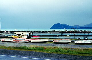
Sekiu is an unincorporated community and census-designated place in Clallam County, Washington, United States. As of the 2010 census it had a population of 27. Overlooking the west side of Clallam Bay and the Strait of Juan de Fuca, it is twinned with the community of Clallam Bay, on the east side of the bay.
Clallam Bay Corrections Center is situated on the Olympic Peninsula in Clallam County, two miles south of the community of Clallam Bay, Washington.

Slip Point Lighthouse was a lighthouse on the Strait of Juan de Fuca, sitting on the point of land that marks the eastern side of Clallam Bay in Clallam County, Washington. The original light was replaced by a freestanding tower in 1951, which was discontinued around 2000 and replaced with a buoy light.
Clallam Transit is the public transportation provider for Clallam County, Washington. It provides 12 fixed-route buses, and coordinates with nearby transit organizations to provide 2 intercounty commuter bus lines. It also provides paratransit for disabled riders.
The Dungeness National Wildlife Refuge is located near the town of Sequim in Clallam County in the U.S. state of Washington, on the Strait of Juan de Fuca. The refuge is composed of 772.52 acres (312.63 ha) which include Dungeness Spit, Graveyard Spit, and portions of Dungeness Bay and Harbor. Dungeness Spit is one of the world's longest natural sand spits, 6.8 miles (10.9 km) long and very narrow. A lighthouse, the New Dungeness Light, built in 1857, is located near the end of the spit. Access to Dungeness Spit is through a Clallam County Park which has hiking trails, picnic areas, and a campground. On January 20, 1915, it was designated as a National Wildlife Refuge by President Woodrow Wilson. Dungeness is one of six refuges in the Washington Maritime National Wildlife Refuge Complex.
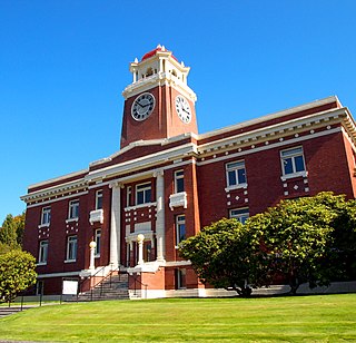
The Clallam County Courthouse is located at 319 Lincoln Street in Port Angeles, Washington. It was built in 1914 and 1915, replacing an older wood courthouse built in 1892, and officially dedicated on June 14, 1915. A 1979 expansion, connected to the historic courthouse by an enclosed bridge, now houses many of the official functions, including courts, public records, and a jail. The historic courthouse houses the Clallam County Museum and the county Parks, Fair and Facilities Department.
Beaver is an unincorporated community in Clallam County, Washington, United States on the Olympic Peninsula. The community lies between U.S. Route 101 and Lake Pleasant.

This is a list of the National Register of Historic Places listings in Clallam County, Washington.

Alice Gertrude was a wooden steamship which operated on the Strait of Juan de Fuca and Puget Sound from 1898 to January 1907, when she was wrecked at Clallam Bay in Washington.
Maple Grove is an unincorporated community in Clallam County, Washington, United States. Maple Grove is assigned the ZIP code 98363.

The 1976 United States presidential election in Washington was held on November 2, 1976 as part of the 1976 United States presidential election. State voters chose nine representatives, or electors, to the Electoral College, who voted for president and vice president.
Gettysburg was a town near the mouth of the Lyre River at the Strait of Juan de Fuca in Clallam County, in the U.S. state of Washington.
Michael C. Chapman is an American customs inspector and politician serving as a Democratic member of the Washington State House of Representatives.


