
The Quillayute River is a river situated on the Olympic Peninsula in Washington. It empties to the Pacific Ocean at La Push, Washington. The Quillayute River is formed by the confluence of the Bogachiel River, Calawah River and the Sol Duc River near the town of Forks, WA. The Dickey River joins the Quillayute from the north, just above the river's mouth at the Pacific Ocean.
Boston is an unincorporated community in, and the county seat of, Bowie County, Texas, United States. According to the Handbook of Texas, the community had a population of 200 in 2000. It is part of the Texarkana metropolitan area.
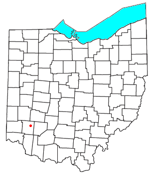
Oregonia is an unincorporated community in northwestern Washington Township, Warren County, Ohio, United States, on the east shore of the Little Miami River about five miles northeast of Lebanon and six miles south of Waynesville. The ZIP Code for Oregonia is 45054.

Mora is an unincorporated community in northern Benton County, Missouri, United States. It is located on Missouri Supplemental Route U approximately sixteen miles south of Sedalia.

Little Hocking is a census-designated place in southern Belpre Township, Washington County, Ohio, United States. It has a post office with the ZIP code 45742. The population of the CPD was 244 at the 2020 census.

South Boston is an unincorporated community in Franklin Township, Washington County, in the U.S. state of Indiana.

Washington Township is one of twelve townships in Buchanan County, Missouri, USA. As of the 2010 census, its population was 78,865.
Falmouth is an unincorporated community in Fayette and Rush counties in the U.S. state of Indiana. Located at the northeastern corner of Union Township and the southeastern corner of Washington Township in Rush County and along the northwestern edge of Fairview Township in Fayette County, it lies at the intersection of CR800E with CR600N /CR400N(Fayette County). Falmouth sits northwest of Connersville and northeast of Rushville, the county seats of Fayette and Rush counties respectively. Although Falmouth is unincorporated, it has a post office, with the ZIP code of 46127.
Omega was a former settlement in Nevada County, California, United States, first populated in 1850 by a single miner, J.A. Dixon, working a claim during the California Gold Rush. The town was located 3.25 miles (5.2 km) east-southeast of the present-day unincorporated town of Washington, California. A sister town, Alpha, located at what is now the site of the historical Omega Hydraulic Diggings, was about 1 mi (1.6 km) north of Omega. In the mid 1850s, following the introduction of hydraulic mining operations nearby, the town prospered. Omega had a post office, and needed to convert a residence into a jail in late 1858.
Boston Ravine is a former settlement in Nevada County, California. Boston Ravine is located 1 mile (1.6 km) south-southwest of Grass Valley. Its elevation is 2,339 ft (713 m) above sea level.
Decaturville is an unincorporated community in Washington County, in the U.S. state of Ohio.
Fillmore is an unincorporated community in Washington County, in the U.S. state of Ohio.
Lower Newport is an unincorporated community in Washington County, in the U.S. state of Ohio.
Rainbow is an unincorporated community in Washington County, in the U.S. state of Ohio.

Boston is an unincorporated community in Summit County, in the U.S. state of Ohio.
Bruceport is an extinct settlement in Pacific County, in the U.S. state of Washington.

Fishtrap is an extinct town in Lincoln County, in the U.S. state of Washington. The GNIS classifies it as a populated place.
Gilmer is a former settlement in Klickitat County, in the U.S. state of Washington. It is named for George W. Gilmer, an early settler and postmaster. A ranch where horses and cattle were raised, Gilmer was an important staging point for goods being shipped over land from the Columbia River to the towns and mines in the central part of Klickitat County. In addition to the ranch, Gilmer had a post office and school for a time in the late nineteenth century. Travelers and settlers were frequently boarded at the Gilmer ranch while en route to their destinations.
Hazel is an unincorporated community in Snohomish County, in the U.S. state of Washington.
Norton Furnace is a ghost town in Bristol County, Massachusetts, United States. The settlement was located approximately 2 mi (3.2 km) south of Norton.


