Jefferson County is a county located in the U.S. state of Washington. As of the 2020 census, the population was 32,977. The county seat and only incorporated city is Port Townsend. The county is named for Thomas Jefferson.
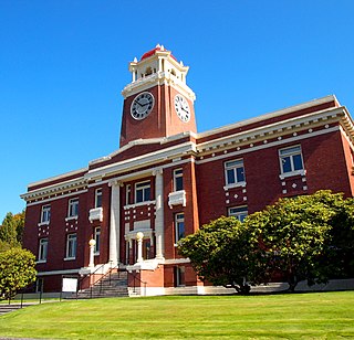
Clallam County is a county in the U.S. state of Washington. As of the 2020 census, the population was 77,155, with an estimated population of 77,805 in 2022. The county seat and largest city is Port Angeles; the county as a whole comprises the Port Angeles, WA Micropolitan Statistical Area. The name is a Klallam word for "the strong people". The county was formed on April 26, 1854. Located on the Olympic Peninsula, it is south from the Strait of Juan de Fuca, which forms the Canada–US border, as British Columbia's Vancouver Island is across the strait.

Forks, also previously known as the unincorporated town of Quillayute, is a city in southwest Clallam County, Washington, United States. The population was 3,335 at the 2020 census. It is named after the forks in the nearby Bogachiel, Calawah, and Sol Duc rivers which join together to form the Quillayute River.
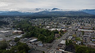
Port Angeles is a city and county seat of Clallam County, Washington, United States. With a population of 19,960 as of the 2020 census, it is the largest city in the county. The population was estimated at 20,134 in 2021.

Sequim is a city in Clallam County, Washington, United States. It is located along the Dungeness River near the base of the Olympic Mountains. The 2020 census counted a population of 8,018, with an estimated population in 2021 of 8,241.

Port Townsend is a city on the Quimper Peninsula in Jefferson County, Washington, United States. The population was 10,148 at the 2020 United States Census. It is the county seat and only incorporated city of Jefferson County. In addition to its natural scenery at the northeast tip of the Olympic Peninsula, the city is known for the many Victorian buildings remaining from its late 19th-century heyday, numerous annual cultural events, and as a maritime center for independent boatbuilders and related industries and crafts. The Port Townsend Historic District is a U.S. National Historic Landmark District. It is also significantly drier than the surrounding region due to being in the rainshadow of the Olympic Mountains, receiving only 19 inches or 480 millimeters of rain per year.
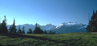
The Olympic Mountains are a mountain range on the Olympic Peninsula of the Pacific Northwest of the United States. The mountains, part of the Pacific Coast Ranges, are not especially high – Mount Olympus is the highest summit at 7,980 ft (2,432 m); however, the eastern slopes rise precipitously out of Puget Sound from sea level, and the western slopes are separated from the Pacific Ocean by the low-lying 20 to 35 km wide Pacific Ocean coastal plain. These densely forested western slopes are the wettest place in the 48 contiguous states. Most of the mountains are protected within the bounds of Olympic National Park and adjoining segments of the Olympic National Forest.

The Olympic Peninsula is a large arm of land in western Washington that lies across Puget Sound from Seattle, and contains Olympic National Park. It is bounded on the west by the Pacific Ocean, the north by the Strait of Juan de Fuca, and the east by Hood Canal. Cape Alava, the westernmost point in the contiguous United States, and Cape Flattery, the northwesternmost point, are on the peninsula. Comprising about 3,600 square miles (9,300 km2), the Olympic Peninsula contained many of the last unexplored places in the contiguous United States. It remained largely unmapped until Arthur Dodwell and Theodore Rixon mapped most of its topography and timber resources between 1898 and 1900.

Western Washington is a region of the United States defined as the area of Washington state west of the Cascade Mountains. This region is home to the state's largest city, Seattle, the state capital, Olympia, and most of the state's residents. The climate is generally far more damp and temperate than that of Eastern Washington.
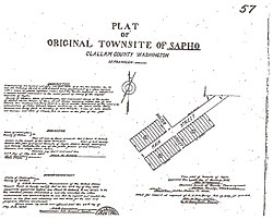
State Route 113 (SR 113), also known as Burnt Mountain Road, is a Washington state highway in Clallam County on the Olympic Peninsula. It connects U.S. Route 101 (US 101) at Sappho to SR 112 near Clallam Bay, traveling north along Beaver Creek and the Pysht River for 10 miles (16 km).

State Route 112 is a state highway and scenic byway in the U.S. state of Washington. It runs east–west for 61 miles (98 km) along the Strait of Juan de Fuca in Clallam County, connecting the Makah Indian Reservation near Neah Bay to U.S. Route 101 (US 101) near Port Angeles.

La Push is a small unincorporated community situated at the mouth of the Quillayute River in Clallam County, Washington, United States, in the western Olympic Peninsula. La Push is the largest community within the Quileute Indian Reservation, which is home to the federally recognized Quileute tribe. La Push is known for its whale-watching and natural environment. The community has historically been located on the coast, however sea level rise led the community to begin managed retreat to higher grounds in 2017.
Clallam Bay is an unincorporated community and census-designated place (CDP) in Clallam County, Washington, United States, at the mouth of the Clallam River into Clallam Bay. Known for its natural environment and hunting, Clallam Bay is partially reliant on tourism. Clallam Bay is considered the twin city of nearby Sekiu. As of the 2010 census, the population of Clallam Bay was 363.

Lake Crescent is a deep lake located entirely within Olympic National Park in Clallam County, Washington, United States, approximately 17 miles (27 km) west of Port Angeles on U.S. Route 101 and nearby to the small community of Piedmont. At an official maximum depth of 624 feet (190 m) it is officially the second deepest lake in Washington. A lake-wide bathymetric survey was performed from 2013 to 2014 by Eian Ray and Jeff Engea and the results of this survey showed the maximum depth as being 596 feet. Using GIS statistical analysis, this survey also showed the lake contains approximately 0.5 cubic miles of fresh water.

U.S. Route 101 (US 101) is a United States Numbered Highway that runs along the West Coast from Los Angeles, California to Tumwater, Washington. Within the state of Washington, US 101 connects cities on the coast of the Pacific Ocean and encircles the Olympic Peninsula around the Olympic Mountains. It also serves as the main access for Olympic National Park, several state parks, and other scenic and recreational areas.
Metacarcinus starri is an extinct species of crab in the family Cancridae, subfamily Cancrinae. The species is known solely from the early Miocene, Clallam Formation and the underlying Pysht Formation deposits on the Olympic Peninsula of Washington state, United States.
Beaver is an unincorporated community in Clallam County, Washington, United States on the Olympic Peninsula. The community lies between U.S. Route 101 and Lake Pleasant.
Pysht is an unincorporated community located on the Olympic Peninsula in Clallam County, Washington, United States and is situated near the mouth the Pysht River.
The Peter Roose Homestead is a historic homestead in the U.S. state of Washington that was settled by Peter Roose, an immigrant from Bollnäs, Sweden, in 1907. Located in Olympic National Park, the site was added as a historic district to the National Register of Historic Places in 2007.
Gettysburg was a town near the mouth of the Lyre River at the Strait of Juan de Fuca in Clallam County, in the U.S. state of Washington.