
The Strait of Juan de Fuca is a body of water about 96 miles long that is the Salish Sea's main outlet to the Pacific Ocean. The international boundary between Canada and the United States runs down the centre of the Strait.

The East Coast of the United States, also known as the Eastern Seaboard, the Atlantic Coast, and the Atlantic Seaboard, is the region encompassing the coastline where the Eastern United States meets the Atlantic Ocean. The Thirteen Colonies, which formed the United States in 1776 were located on this coast, and it has played an important role in the development of the United States.

Massapequa is a hamlet and census-designated place (CDP) in the Town of Oyster Bay in Nassau County, on the South Shore of Long Island, in New York, United States. The population of the CDP was 21,355 at the time of the 2020 census.

Neah Bay is a census-designated place (CDP) on the Makah Reservation in Clallam County, Washington, United States. The population was 935 at the 2020 census. It is across the Canada–US border from British Columbia. Europeans originally called it "Scarborough Harbour" in honor of Captain James Scarborough of the Hudson's Bay Company. It was changed to Neah in 1847 by Captain Henry Kellett. Kellett spelled it "Neeah Bay". The name "Neah" refers to the Makah Chief Dee-ah, pronounced Neah in the Klallam language. During the summer months, Neah Bay is a popular fishing area for sports fishermen. Another attraction is the Makah Museum, which houses artifacts from a Makah village partly buried by a mudslide around 1750. Many people also visit to hike the Cape Trail or camp at Hobuck Beach. An emergency response tug is stationed at Neah Bay which has saved 41 vessels since its introduction in 1999.
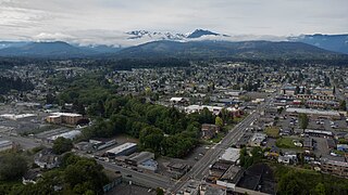
Port Angeles is a city and county seat of Clallam County, Washington, United States. With a population of 19,960 as of the 2020 census, it is the largest city in the county. The population was estimated at 20,134 in 2021.

Easton is an unincorporated community and census-designated place (CDP) in Kittitas County, Washington, United States. The population was 478 at the 2010 census. Easton is the annual site of the start/finish line for the Cascade Crest 100-mile ultra-running race.

A Mediterranean climate, also called a dry summer climate, described by Köppen as Cs, is a temperate climate type that occurs in the lower mid-latitudes. Such climates typically have dry summers and wet winters, with summer conditions ranging from warm to hot and winter conditions typically being mild to cool. These weather conditions are typically experienced in the majority of Mediterranean-climate regions and countries, but remain highly dependent on proximity to the ocean, altitude and geographical location.
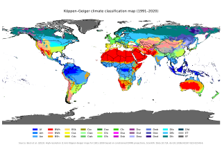
The Köppen climate classification is one of the most widely used climate classification systems. It was first published by German-Russian climatologist Wladimir Köppen (1846–1940) in 1884, with several later modifications by Köppen, notably in 1918 and 1936. Later, German climatologist Rudolf Geiger (1894–1981) introduced some changes to the classification system in 1954 and 1961, which is thus sometimes called the Köppen–Geiger climate classification.

The climate of Virginia, a state on the east coast of the United States, is mild compared to more northern areas of the United States such as New England and the Midwest. Most of Virginia east of the Blue Ridge mountains, the southern part of the Shenandoah Valley, and the Roanoke Valley, has a humid subtropical climate. In the mountainous areas west of the Blue Ridge, the climate is warm-summer humid continental or oceanic climate. Severe weather, in the form of tornadoes, tropical cyclones, and winter storms, impacts the state on a regular basis. Central Virginia received significant snowfall of 20 inches in December 2009.
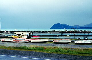
Sekiu, a small fishing village, is an unincorporated community and census-designated place in Clallam County, Washington, United States. As of the 2020 census it had a population of 24. Overlooking the west side of Clallam Bay and the Strait of Juan de Fuca, it is twinned with the community of Clallam Bay, on the east side of the bay.
Doty, Washington is an unincorporated community located 1.3-miles directly west of Dryad and 5 miles east of Pe Ell on Washington State Route 6. As of 2023, approximately 250 people reside in or around Doty, which boasts a general store, post office, fire department, and two churches. Logging and farming are the industries that most of the residents rely on for income.

The climate of Romania is continental, transitioning into humid subtropical on the eastern coast, influenced by polar intrusions, and therefore characterized by harsh winters. The mountain ranges of the Carpathian arc have a cool mountain climate with high humidity throughout the year.
Huntington Lake is an unincorporated community in Fresno County, California. It is located on the west end of Huntington Lake 2 miles (3.2 km) north of Big Creek, at an elevation of 7027 feet.

Mount Angeles is located just south of Port Angeles, Washington in the Olympic National Park. It is the highest peak in the Hurricane Ridge area. The summit, which offers panoramic views of the Strait of Juan de Fuca and many of the peaks of the interior Olympic Mountains can be climbed from the Klahane Ridge trail.

The climate of New Jersey classification of the U.S. state of New Jersey is humid subtropical in South Jersey with a humid continental climate in North Jersey, particularly in the northwestern area of the state. The northwest part of New Jersey is the snowiest due to the higher elevations that earn it a Dfb classification. During the winters, New Jersey can experience Nor'easters, which are snowstorms that affect the Northeastern United States, and Atlantic Canada. However, many would-be snow events in the state end up turning to rain due to warm ocean air being brought in by the storm. New Jersey's climate is shaped by its proximity to the Atlantic Ocean which provides moisture and moderates temperatures. According to climatology research by the U.S. National Oceanic and Atmospheric Administration, New Jersey has been the fastest-warming state by average air temperature over a 100-year period beginning in the early 20th century, related to global warming.

Europe is generally characterized by a temperate climate. Most of Western Europe has an Oceanic climate, in the Köppen climate classification, featuring cool to warm summers and cool winters with frequent overcast skies. Southern Europe has a distinctively Mediterranean climate, which features warm to hot, dry summers and cool to mild winters and frequent sunny skies. Central-eastern Europe is classified as having a humid continental climate, which features warm to hot summers and cold winters.

La Grande is an unincorporated community and census-designated place in Pierce County, Washington, United States. La Grande is located along Washington State Route 7 3.5 miles (5.6 km) southwest of Eatonville. La Grande has a post office with ZIP code 98348.
Valencia and its metropolitan area have a Mediterranean climate bordering on a semi-arid climate with mild winters and warm to hot summers. According to Troll-Paffen climate classification, Valencia has a warm-temperate subtropical climate and according to Siegmund/Frankenberg climate classification, Valencia has a subtropical climate.
Muddy Mountain is a peak in the Laramie Mountains approximately 12 miles (19 km) south-south-east of Casper, Wyoming. There is a two-mile (3.2 km) "interpretive nature trail" maintained by the Bureau of Land Management, as well as a series of trails popular with mountain bikers, horseback riders, and ATVs in the summer, and snowmobiles in the winter.
Lisbon and its metropolitan area feature a mild Mediterranean climate, with short, mild and rainy winters and warm to hot, dry summers. According to the Troll-Paffen climate classification, Lisbon has a warm-temperate subtropical climate. According to the Siegmund/Frankenberg climate classification, Lisbon has a subtropical climate.

