Rancho Los Encinos

Last updated

Rancho El Encino
Los Encinos Garnier House.jpg
The limestone Garnier building at Rancho Los Encinos: restored from 1994 Northridge earthquake damages and now the park's Visitor Center.
USA Los Angeles Metropolitan Area location map.svg
Red pog.svg
Location Encino, California
Coordinates 34°9′34.40″N118°29′58.28″W / 34.1595556°N 118.4995222°W / 34.1595556; -118.4995222
Built1845
Architectural style Spanish Colonial, Basque vernacular
NRHP reference No. 71000142 [1]
Added to NRHPFebruary 24, 1971

Rancho Los Encinos (also Rancho El Encino and Rancho Encino) was a Spanish grazing concession, [2] and later Mexican land granted cattle and sheep rancho and travelers way-station on the El Camino Real in the San Fernando Valley, in present-day Encino, Los Angeles County, California. The original 19th-century adobe and limestone structures and natural Encino Springs are now within the Los Encinos State Historic Park.

Contents

History

Origins

The name of the rancho derives from the original designation of the Valley by the Portola expedition of 1769: El Valle de Santa Catalina de Bononia de los Encinos, [3] with encino being the Spanish name for Oaks, after the many native deciduous Valley Oak (Quercus lobata) and evergreen Coast Live Oak (Quercus agrifolia) trees across the valley's savannah, which are still found on the park's property.

The naturally carbonated Encino Springs on the land were used by Tongva people of Suitcanga village. Portola camped here, and the springs were a necessary stop for travelers on El Camino Real, and the Ventura Road, which became Ventura Boulevard.

The adobe house completed in 1850, built by Vicente de la Osa at Rancho Los Encinos Los Encinos De La Osa Adobe southern face.jpg
The adobe house completed in 1850, built by Vicente de la Osa at Rancho Los Encinos

Francisco Reyes, alcalde , or mayor of Pueblo de Los Angeles from 1793–1795, established the original Rancho Encino in the northern San Fernando Valley. In or around 1797 Reyes ceded this land to the Roman Catholic Church to be the site of Mission San Fernando Rey de España, and relocated his Rancho Encino to one square Spanish league (4,460 acres) of land in the southern valley adjacent to El Camino Real and between the Los Angeles River and Santa Monica Mountains. [4]

Reyes was accused of mistreating the Mission Indians who worked his rancho, and in 1845 Mexican Governor Pío Pico re-granted the property to three of the Tongva Native American workers, recorded as Ramon, Francisco, and Roque, who raised cattle and corn. Ramon, Francisco and Roque had worked the land beginning in about 1834, however, by the time the claim was recognized in 1845 "Francisco and Roque were dead. Their widows inherited the land and worked it for a few years with Ramon and his family until 1849 when Roman deserted them and his daughter Aguedo, and ran off to the gold fields." The surviving widows of the grantees sold out. [5]

In 1849, Don Vicente de la Osa or de la Ossa, the original owner of the nearby Rancho Providencia, acquired the Tongva Indians' interests in the property. [6] His wife was Rita de Guillén de la Ossa, daughter of Eulalia Pérez de Guillén Mariné of Rancho San Pascual. He built a 9-room adobe farmhouse in 1849–1850 that still stands near the spring. [7] According to the Los Angeles Times, "A petition for Rancho el Encino was presented to the U.S. Board of Land Commissioners in 1852, in which Don Vincent de la Ossa claimed he had purchased one-third of the property in 1849. Unable to pay his taxes, Ramon sold the final portion in 1857 to de la Osa, who paid $9.33 for 312 acres." [8] After de la Osa died, his widow sold it to L.A. County sheriff James Paul Thompson, who was also her future son-in-law. [8]

With the cession of California to the United States following the Mexican-American War, the 1848 Treaty of Guadalupe Hidalgo provided that the land grants would be honored. As required by the Land Act of 1851, a claim for Rancho Los Encinos was filed with the Public Land Commission in 1852, [9] [10] and the grant was patented to Vicente de la Osa et al Jan. 8, 1873, for 4,460.73 acres.

Boom and bust

Vicente de la Ossa, c. 1850 Vicente de la Ossa.JPG
Vicente de la Ossa, c.1850

The California Gold Rush of 1849 created a near-insatiable demand for beef, which was raised on the ranchos of southern California, including Rancho Los Encinos, and driven on the hoof to northern markets serving the gold fields. But the boom market in Southern California began to decline as early as 1855 as it became profitable to drive cattle and sheep to California from the midwest and Texas, and the drought of 1856 increased the pressure on the ranchos. [11]

The De La Osa rancho was a popular stopping point for El Camino Real and Camino Nuevo travelers, who could expect hospitality at the ranch house. The Butterfield Overland Mail stagecoach route between St. Louis, Missouri and San Francisco via Fort Yuma and Los Angeles passed through the rancho, making its first run in the fall of 1858. [12] A new stagecoach route opened in 1861, diverging from the old El Camino Real at Rancho Los Encinos and heading for Santa Barbara via the Santa Susana Stage Road over Santa Susana Pass in the Simi Hills. The rancho was a stagecoach stop on it until the new railroad replaced Butterfield stages in 1875. [13] [14] [15]

Rancho Los Encinos: The Garnier building in 1900 RanchoEncino-1900.jpg
Rancho Los Encinos: The Garnier building in 1900

With the cattle market in collapse and besieged by mounting debts, in 1859 De la Osa converted his house into a roadside inn and began to charge patrons for his legendary Californio hospitality. [16] Don Vicente De la Osa died in 1861, and his widow Rita sold the property to James Thompson in 1867, [16] who raised sheep on the rancho for two years. Thompson in turn sold the property to two Basque brothers, Eugene and Phillipe Garnier, in 1869. Eugene Garnier built a two-story limestone farmhouse similar to the former family home in the French Basque Country, [17] and a brick-lined pond collecting the spring's outflow and shaped like a Spanish guitar. The Garnier brothers also raised sheep on the property, and were known for the fine quality of their fleece, but they in turn became overextended and lost the property to foreclosure in 1878. [6]

The property changed hands three times in the next twenty years, having been acquired by Simon Gless a Basque who was married to a French woman and four other native women; eventually, he sold the property to his Basque father-in-law, Domingo Amestoy, <Gless family archives>in 1889. The fields were used for wheat farming, as was most of the Valley after Isaac Newton Van Nuys introduced dryland farming there. The Amestoy family lived on the property until 1945, selling off 1,170 acres (5 km2) of land in 1916 that would become the community of Encino, and further subdividing the ranchlands thereafter.

In a story typical of the San Fernando Valley's rapid urbanization, the adobe was used as the sales office for the post-war subdivisions surrounding it—and was to be torn down and used as commercial property. Concerned neighbors led a fight to have the adobe, and the spring, to be purchased by the State of California.

The last remaining parcel, including the historic buildings and the spring, was acquired by the state of California in 1949.

Los Encinos State Historic Park

Rancho Los Encinos: Historical monument marker, 1950 Los Encinos De La Osa Adobe Marker.jpg
Rancho Los Encinos: Historical monument marker, 1950
1994 earthquake-damaged Amestoy storage building at Rancho Los Encinos. Los Encinos 1902 Food Storage Building Northridge Earthquake damage 3.jpg
1994 earthquake-damaged Amestoy storage building at Rancho Los Encinos.

All of the historic buildings in the park were heavily damaged in the 1994 Northridge earthquake. The De la Osa adobe and the stone Garnier building have been repaired and restored, with the Garnier building now serving as a visitor center with historic photographs and exhibits of the rancho's past. [18] The Los Encinos Photos archives are also online. [18] The 1902 river stones and mortar walled, double-roofed, food-cool storage buildings built for the Amestoys still show signs of the earthquake and are used for Park storage.

A major Tongva village or rancheria site, carbon-dated at over 3,000 years old, was discovered in 1984 directly across Ventura Boulevard during excavation for a new structure. Archeologists found two million artifacts, such as lithic stone tools, shel and stone beads, and arrowheads, and ancient burial remains. The park displays some of the pre-contact artifacts. [19]

In 2011, the State of California threatened to close the park, because the park makes no revenue to equalize the employees needed. Through community effort and the Encino Neighborhood Council, an anonymous donor was found who volunteered $150,000 (pending as of 1/12) to keep the park open.

The park is located at 16756 Moorpark Street, Encino, California, 91436-1068, and is open to the public 10 AM to 5 PM, Wednesday through Sunday. There is a pedestrian entrance on Ventura Boulevard.

See also

Notes

  1. "National Register Information System". National Register of Historic Places . National Park Service. January 23, 2007.
  2. Beck, Warren A. and Ynez D. Haase, Historical Atlas of California, p. 37
  3. Bearchell, Charles, and Larry D. Fried: The San Fernando Valley Then and Now, p. 93
  4. Bearchell and Fried, p. 28, 68-69, 93-95
  5. "Los Encinos State Historic Park History". los-encinos.org. Retrieved November 12, 2023.
  6. 1 2 Bearchell and Fried, p. 94-96
  7. Kielbasa, Historic Adobes of Los Angeles County, p. 34.
  8. 1 2 Archives, L. A. Times (January 18, 1998). "Back to the Rancho". Los Angeles Times. Retrieved November 12, 2023.
  9. United States. District Court (California : Southern District) Land Case 392 SD
  10. Finding Aid to the Documents Pertaining to the Adjudication of Private Land Claims in California, circa 1852-1892
  11. Cleland, Robert Glass: The Cattle on a Thousand Hills: Southern California, 1850-1870
  12. Link, Tom: Universal City – North Hollywood, a Centenniel Portrait, p. 25
  13. The stagecoach routes can clearly be seen on period maps; see the Map Gallery.
  14. Bevill, Arthur D. (2007). Santa Susana Pass State Historic Park Cultural Resource Survey Historic Overview (PDF). Archived from the original (PDF) on October 27, 2008.
  15. Old Stagecoach Trail at www.trails.com
  16. 1 2 Kielbasa, p. 35
  17. a picture of the Garnier house in southern France can be seen in the Visitor Center
  18. 1 2 "Historic Parks of Southern California". Archived from the original on October 1, 2003. Retrieved August 16, 2023.
  19. laokay: History of Rancho Los Encinos accessed 8/20/2010

Related Research Articles

<span class="mw-page-title-main">San Fernando Valley</span> Large populated valley in Los Angeles County, California, US

The San Fernando Valley, known locally as the Valley, is an urbanized valley in Los Angeles County, California. Situated to the north of the Los Angeles Basin, it contains a large portion of the City of Los Angeles, as well as unincorporated areas and the incorporated cities of Burbank, Calabasas, Glendale, Hidden Hills, and San Fernando. The valley is well known for its iconic film studios such as Warner Bros. Studio and Walt Disney Studios. In addition, it is home to the Universal Studios Hollywood theme park.

<span class="mw-page-title-main">Chatsworth, Los Angeles</span> Neighborhood of Los Angeles in California, United States

Chatsworth is a suburban neighborhood in Los Angeles, California, in the San Fernando Valley.

<span class="mw-page-title-main">Encino, Los Angeles</span> Neighborhood of Los Angeles in California, United States

Encino is a neighborhood in the San Fernando Valley region of Los Angeles, California.

<span class="mw-page-title-main">Ventura Boulevard</span> Thoroughfare in San Fernando Valley

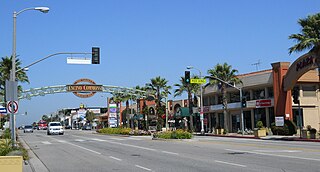
Ventura Boulevard is one of the primary east–west thoroughfares in the San Fernando Valley region of the City of Los Angeles, California. Ventura Boulevard is one of the oldest routes in the San Fernando Valley as it was originally a part of the Camino Real. It was also U.S. Route 101 (US 101) before the freeway was built, and it was also previously signed as U.S. Route 101 Business.

<span class="mw-page-title-main">Domingo Amestoy</span> Basque sheepherder and banker

Domingo Amestoy —born Dominique— (1822–1892) was a Basque sheepherder, and banker, one of the original founders to provide the financing for the Farmers and Merchants Bank in Los Angeles, California, in 1871.

<span class="mw-page-title-main">Santa Susana Pass</span> Mountain pass in Los Angeles County, California, United States

The Santa Susana Pass, originally Simi Pass, is a low mountain pass in the Simi Hills of Southern California, connecting the San Fernando Valley and Los Angeles neighborhood of Chatsworth, to the city of Simi Valley and eponymous valley.

<span class="mw-page-title-main">Andrés Pico</span> American politician

Andrés Pico was a Californio who became a successful rancher, fought in the contested Battle of San Pascual during the Mexican–American War, and negotiated promises of post-war protections for Californios in the 1847 Treaty of Cahuenga. After California became one of the United States, Pico was elected to the state Assembly and Senate. He was appointed as the commanding brigadier general of the state militia during the U.S. Civil War.

<span class="mw-page-title-main">Campo de Cahuenga</span> Historic house in California, United States

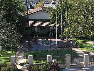
The Campo de Cahuenga, near the historic Cahuenga Pass in present-day Studio City, California, was an adobe ranch house on the Rancho Cahuenga where the Treaty of Cahuenga was signed between Lieutenant Colonel John C. Frémont and General Andrés Pico in 1847, ending hostilities in California between Mexico and the United States. The subsequent Treaty of Guadalupe Hidalgo of 1848, ceding California, parts of Colorado, Nevada, New Mexico, and Arizona to the United States, formally ended the Mexican–American War. From 1858 to 1861 the Campo de Cahuenga became a Butterfield Stage Station.

<span class="mw-page-title-main">Eulalia Pérez de Guillén Mariné</span> Mexican-American mayor doma (d. 1878)

Eulalia Pérez de Guillén Mariné was a Californio who was mayordoma of Mission San Gabriel Arcángel and grantee of Rancho del Rincón de San Pascual in the San Rafael Hills, in present-day Los Angeles County, California. She claimed to have been born in 1766, if so making her 112 years old at the time of her death in 1878, but her case has not been verified or fully proven.

<span class="mw-page-title-main">Elizabeth Lake (Los Angeles County, California)</span> Intermittent lake in Elizabeth Lake, California

Elizabeth Lake is a natural sag pond that lies directly on the San Andreas Fault in the northern Sierra Pelona Mountains, in northwestern Los Angeles County, southern California.

<span class="mw-page-title-main">Los Encinos State Historic Park</span> State historic park in Los Angeles County, California, United States

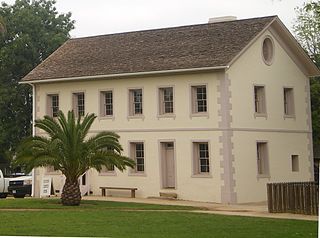
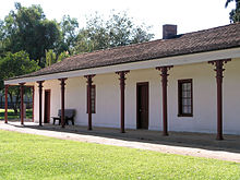
Los Encinos State Historic Park is a state park unit of California, preserving buildings of Rancho Los Encinos. The park is located near the corner of Balboa and Ventura Boulevards in Encino, California, in the San Fernando Valley. The rancho includes the original nine-room de la Ossa Adobe, the two-story limestone Garnier building, a blacksmith shop, a natural spring, and a pond. The 4.7-acre (1.9 ha) site was established as a California state park in 1949.

<span class="mw-page-title-main">Rómulo Pico Adobe</span> Historic house in California, United States

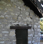
Rómulo Pico Adobe, also known as Ranchito Rómulo and Andrés Pico Adobe, was built in 1834 and is the oldest residence in the San Fernando Valley, making it the second oldest residence in Los Angeles. Built and owned by the Pico family of California, a prominent Californio family, the adobe is located in the Mission Hills section of the city and is a short distance from the San Fernando Mission. It was listed on the National Register of Historic Places in 1966.

<span class="mw-page-title-main">Rancho Las Vírgenes</span> Historic land grant in Southern California, United States

Rancho Las Vírgenes was a 17,760-acre (71.9 km2) land grant in the Santa Monica Mountains and Simi Hills, in present day western Los Angeles County, California. The lands of the Rancho Las Vírgenes included present day Agoura Hills, Oak Park, and Westlake Village and part of the Santa Monica Mountains.

Juan Francisco Reyes (1749–1809), soldado de cuera on the 1769 Portola expedition, alcalde of the Pueblo de Los Angeles for three terms, and recipient of the Spanish land grant for Rancho Los Encinos and later Lompoc.

<span class="mw-page-title-main">Rancho La Providencia</span> Mexican land grant in Southern California

Rancho La Providencia was a 4,064-acre (16.45 km2) Mexican land grant in present-day Los Angeles County, California given by governor Juan B. Alvarado in 1843 to Vicente de la Osa. The majority of Rancho Providencia land north of the modern channel of the Los Angeles River is now part of Burbank. The street grid change along Burbank Boulevard marks the northwestern boundary of the rancho grant. The Walt Disney Studios, Warner Bros. Studios, NBC Studios Burbank, Providence High School, and Providence Saint Joseph Medical Center are all within the former boundaries of Rancho Providencia. The Burbank Equestrian Center and portions of the Rancho south of the river are now part of the city of Los Angeles.

<span class="mw-page-title-main">History of the San Fernando Valley</span> Aspect of history

The history of the San Fernando Valley from its exploration by the 1769 Portola expedition to the annexation of much of it by the City of Los Angeles in 1915 is a story of booms and busts, as cattle ranching, sheep ranching, large-scale wheat farming, and fruit orchards flourished and faded. Throughout its history, settlement in the San Fernando Valley was shaped by availability of reliable water supplies and by proximity to the major transportation routes through the surrounding mountains.

Rancho El Escorpión was a 1,110-acre (4.5 km2) Mexican land grant in present day Los Angeles County, California given in 1845 by Governor Pío Pico to three Chumash Native Americans - Odón Chijulla, Urbano, and Mañuel. The half league square shaped Rancho El Escorpión was located at the west end of the San Fernando Valley on Bell Creek against the Simi Hills, and encompassed parts of present day West Hills and Woodland Hills.

El Camino Viejo a Los Ángeles, also known as El Camino Viejo and the Old Los Angeles Trail, was the oldest north-south trail in the interior of Spanish colonial Las Californias (1769–1822) and Mexican Alta California (1822–1848), present day California. It became a well established inland route, and an alternative to the coastal El Camino Real trail used since the 1770s in the period.

<span class="mw-page-title-main">Encino Hot Springs</span> Thermal springs

Encino Hot Springs are historic thermal springs located at the site of Siutcanga village, a settlement of the Tongva-Kizh people of the area now known as Southern California. It was used by several tribes of Indigenous peoples for thousands of years. Later, after settlement, the artesian springs were used as a water source for Rancho Los Encinos in what is now the San Fernando Valley region of Los Angeles County, California. In the 1880s it was a rest stop on the Butterfield Stagecoach route. The springs are located in the modern-day Los Encinos State Historic Park.

<span class="mw-page-title-main">Vicente de la Osa</span> Californio landowner (1808–1861)

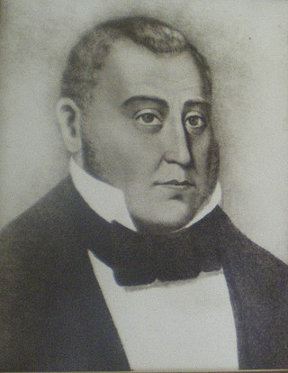
Vicente de la Osa was a Californio city official, tavern owner, and cattle rancher who owned Rancho Providencia and Rancho Los Encinos in what is now the San Fernando Valley area of Southern California in the United States.

References