
The Metro Green Line is an 11-mile (18 km) light rail line that connects the central business districts of Minneapolis and Saint Paul in Minnesota as well as the University of Minnesota. An extension is under construction that will extend the line to the southwest connecting St. Louis Park, Hopkins, Minnetonka and Eden Prairie. The line follows the path of former Metro Transit bus route 16 along University Avenue and Washington Avenue. It is the second light-rail line in the region, after the Blue Line, which opened in 2004 and connects Minneapolis with the southern suburb of Bloomington.
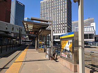
Central station is a light rail station along the Green Line in Saint Paul, Minnesota. It is unique among Central Corridor stations in that it is not located in the middle of or directly adjacent to a road, but rather at a 45° angle to surrounding streets like the U.S. Bank Stadium station shared with the Blue Line in Minneapolis. It is located on the block bounded by 5th Street, Minnesota Street, 4th Street, and Cedar Street.

Capitol/Rice Street station is a light rail station along the Metro Green Line in Saint Paul, Minnesota. It is located along the south side of University Avenue between Rice Street and Park Street/Rev. Dr. Martin Luther King Jr. Boulevard. This is on the north side of Leif Erikson Park, west of the Minnesota State Capitol.

Lexington Parkway station is a light rail station along the Metro Green Line in Saint Paul, Minnesota. It is located along University Avenue on both sides of the intersection with Lexington Parkway. The station has split side platforms, with the westbound platform on the north side of the tracks west of Lexington and the eastbound platform on the south side of the tracks east of the intersection.
Snelling Avenue station is a light rail station along the Metro Green Line in Saint Paul, Minnesota. It is located along University Avenue on either side of the intersection with Snelling Avenue. The station has split side platforms, with the westbound platform on the north side of the tracks west of Snelling and the eastbound platform on the south side of the tracks east of the intersection.

Fairview Avenue station is a light rail station along the Metro Green Line in Saint Paul, Minnesota. It is located along University Avenue between Lynnhurst Avenue and Fairview Avenue. A preliminary architectural design revealed in May 2009 featured oak trees and was inspired by the trees in the neighborhood's parks.

Raymond Avenue station is a light rail station along the Metro Green Line in Saint Paul, Minnesota. It is located a block east of the intersection of Raymond Avenue with University Avenue, between Carleton Street and La Salle Street.

Westgate station is a light rail station along the Metro Green Line in Saint Paul, Minnesota. It is located in the median of University Avenue with split side platforms either side of Berry Street. The westbound platform in on the north side of the tracks west of Berry Street, while the eastbound platform is on the south side of the tracks on the east side of the intersection. It is the last station in Saint Paul before entering Minneapolis.

Prospect Park station is a light rail station on the Green Line in the Prospect Park neighborhood of Minneapolis. It is located in the median of 29th Avenue just south of the University of Minnesota Transitway between 4th Street Southeast and University Avenue. It is the last stop in Minneapolis on the Green Line before Saint Paul.
Stadium Village station is a light rail station on the Green Line on the University of Minnesota campus in Minneapolis. Located in the Stadium Village area, it lies east of 23rd Avenue Southeast between University Avenue and 4th Street, across the road from Huntington Bank Stadium. East of the station, the rail line parallels the U of M Transitway until 29th Street SE, where it turns to enter Prospect Park station.
East Bank station is a light rail station along the Green Line in Minneapolis, Minnesota, located on Washington Avenue on the East Bank campus of the University of Minnesota. It is located between Union Street and Harvard Street. This is south of the Transportation and Safety Building and north of Moos Tower and Weaver-Densford Hall.

Dale Street station is a light rail station along the Metro Green Line in Saint Paul, Minnesota. It is located along University Avenue on both sides of the intersection with Dale Street. The station has split side platforms, with the westbound platform on the north side of the tracks west of Dale and the eastbound platform on the south side of the tracks east of Dale.

Robert Street station is a light rail station along the Metro Green Line in Saint Paul, Minnesota. It is located on the west side of Robert Street between 14th Street and Columbus Avenue. This is in an area of government buildings a short distance from the Minnesota State Capitol.
The Minneapolis Streetcar System was a proposed streetcar system for the city of Minneapolis, Minnesota. Extensive studies and plans for the new system were completed in 2007 and presented to the Minneapolis City Council in January 2008; on April 2, 2010, the Council voted to approve the plans and seek funding. On December 21, 2010 the Federal Transit Administration granted $900,000 to further study the Nicollet and Central Avenue corridors. In June 2021, after no further development on the system, a bill authorized the Metropolitan Council to use funds collected for the Nicollet-Central line to be spent on bus rapid transit funding.

Hamline Avenue station is a light rail station on the Metro Green Line in Saint Paul, Minnesota. It is located along University Avenue on both sides of the intersection with Hamline Avenue. The station has split side platforms, with the westbound platform on the north side of the tracks west of Hamline and the eastbound platform on the south side of the tracks east of the intersection.

Victoria Street station is a light rail stop on the Metro Green Line along University Avenue on both sides of the intersection with Victoria Street in Saint Paul, Minnesota. The station has split side platforms, with the westbound platform on the north side of the tracks west of Victoria and the eastbound platform on the south side of the tracks east of the intersection.

Western Avenue station is a light rail station on the Metro Green Line in Saint Paul, Minnesota, United States. It is located along University Avenue on both sides of the intersection with Western Avenue. The station has split side platforms, with the westbound platform on the north side of the tracks west of Western and the eastbound platform on the south side of the tracks east of Western.

Metro is a transit network in Minnesota serving the cities of Minneapolis and Saint Paul. It also provides service to some suburban areas. As of 2022 the system consists of two light rail lines and five bus rapid transit (BRT) lines all of which are operated by the local public transit company: Metro Transit. The five lines connect Downtown Minneapolis and St Paul with the Bloomington, Minneapolis-St Paul International Airport, Roseville, Richfield, Burnsville and Brooklyn Center.

The K Line Northern Extension Project, formerly known as the Crenshaw Northern Extension Project, is a project planning a Los Angeles Metro Rail light rail transit corridor extension connecting Expo/Crenshaw station to Hollywood/Highland station in Hollywood. The corridor is a fully underground, north-south route along mostly densely populated areas on the western side of the Los Angeles Basin; it would be operated as part of the K Line. The Los Angeles County Metropolitan Transportation Authority (Metro) is prioritizing the project along with pressure from the West Hollywood residents. Construction is slated to start in 2041 and begin service by 2047 unless means to accelerate the project are found.

