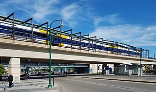
The Metro Blue Line is a 12-mile (19.3 km) light rail line in Hennepin County, Minnesota, that is part of the Metro network. It travels from downtown Minneapolis to Minneapolis–Saint Paul International Airport and the southern suburb of Bloomington. Formerly the Hiawatha Line prior to May 2013, the line was originally named after the Milwaukee Road's Hiawatha passenger train and Hiawatha Avenue, reusing infrastructure from the former and running parallel to the latter for a portion of the route. The line opened June 26, 2004, and was the first light rail service in Minnesota. An extension, Bottineau LRT, is planned to open in 2028.
Metro Transit is the primary public transportation operator in the Minneapolis–Saint Paul area of the U.S. state of Minnesota and the largest operator in the state. Although Metro Transit is one of the smallest transit systems for a large metropolitan area in the United States, it has previously been ranked as one of the best. In 2022, the system had a ridership of 38,794,700, or about 137,400 per weekday as of the second quarter of 2023.

The Metro Green Line is an 11-mile (18 km) light rail line that connects the central business districts of Minneapolis and Saint Paul in Minnesota as well as the University of Minnesota. An extension is under construction that will extend the line to the southwest connecting St. Louis Park, Hopkins, Minnetonka and Eden Prairie. The line follows the path of former Metro Transit bus route 16 along University Avenue and Washington Avenue. It is the second light-rail line in the region, after the Blue Line, which opened in 2004 and connects Minneapolis with the southern suburb of Bloomington.

The Warehouse District/Hennepin Avenue station is a light rail station on the METRO Blue Line and Green Line in Minneapolis, Minnesota. This was the original northern terminus of the Blue Line until the new Target Field station opened on November 14, 2009 to provide access to the new Northstar Commuter Rail line.

Government Plaza is a Metro light rail station on the Blue Line and Green Line in Minneapolis, Minnesota. The station is located on 5th Street South, between 3rd and 4th Avenues South in downtown Minneapolis. This station opened on June 26, 2004, with initial light rail service in the Twin Cities.

U.S. Bank Stadium station station is a light rail station on the Metro Blue Line and Green Line in Minneapolis, Minnesota.

Cedar–Riverside station is a light rail station on the Blue Line in Minneapolis, Minnesota.
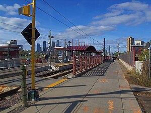
Lake Street/Midtown station, also referred locally as either the Lake Street station or Midtown station, is a Blue Line light rail stop in Minneapolis, Minnesota, United States.

38th Street station is a light rail station on the Blue Line in Minneapolis, Minnesota.
46th Street station is a light rail station on the Metro Blue Line in Minneapolis, Minnesota. This station is located on the northwest corner of the intersection of 46th Street and Minnesota State Highway 55, in the Ericsson neighborhood. This is a side-platform station. Service began at this station when the Blue Line opened on June 26, 2004.

Lake Street is a major east-west thoroughfare between 29th and 31st streets in Minneapolis, Minnesota United States. From its western most end at the city's limits, Lake Street reaches the Chain of Lakes, passing over a small channel linking Bde Maka Ska and Lake of the Isles, and at its eastern most end it reaches the Mississippi River. In May 2020, the Lake Street corridor suffered extensive damage during local unrest over the death of George Floyd. In August of the same year, city officials designated East Lake Street as one of seven cultural districts to promote racial equity, preserve cultural identity, and promote economic growth.

The Southwest LRT is an under–construction 14.5-mile (23.3 km) light rail transit corridor in Hennepin County, Minnesota, with service between Minneapolis and Eden Prairie. The estimated one-way travel time from Southwest Station in Eden Prairie to Target Field Station in Minneapolis is 32 minutes. The Southwest LRT will extend through St. Louis Park, Hopkins and Minnetonka along the route. Major locations on the line will include Bde Maka Ska, Cedar Lake, the Walker Art Center, the Minneapolis Sculpture Garden and Target Field in downtown Minneapolis.

West Bank station is a light rail station along the Metro Green Line in Minneapolis. It serves the West Bank campus of the University of Minnesota, as well as the Cedar-Riverside neighborhood.

Longfellow is a defined community in Minneapolis, Minnesota which includes five smaller neighborhoods inside of it: Seward, Cooper, Hiawatha, Howe and Longfellow. The community is a mix of agri-industrial properties along the old Northern Pacific Railway, expansive parkland surrounding the famous Minnehaha Falls, and smaller residential areas.

Metro is a transit network in Minnesota serving the cities of Minneapolis and Saint Paul. It also provides service to some suburban areas. As of 2022 the system consists of two light rail lines and five bus rapid transit (BRT) lines all of which are operated by the local public transit company: Metro Transit. The five lines connect Downtown Minneapolis and St Paul with the Bloomington, Minneapolis-St Paul International Airport, Roseville, Richfield, Burnsville and Brooklyn Center.

The Metro A Line is a bus rapid transit line in the Twin Cities, Minnesota operated by Metro Transit. The A Line operates primarily along the Snelling Avenue corridor and travels through the cities of Minneapolis, Saint Paul, Falcon Heights, and Roseville. From the Blue Line in Minneapolis, the line travels past Minnehaha Park, through the Highland Village commercial area, past Macalester College, and connects to the Green Line near Allianz Field. The line continues through Saint Paul, past Hamline University, before traveling through Falcon Heights and Roseville, where the line passes the Minnesota State Fairgrounds, Har Mar Mall, and terminates at Rosedale Center.

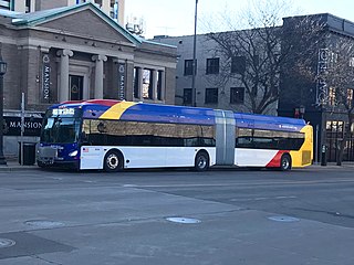
The Metro C Line is a bus rapid transit line in Brooklyn Center and Minneapolis, Minnesota operated by Metro Transit. The line is part of Metro Transit's Metro network of light rail and bus rapid transit lines. The route operates from the Brooklyn Center Transit Center along Penn Avenue and Olson Memorial Highway, terminating in downtown Minneapolis. The route is analogous to the existing Route 19 and is projected to increase ridership on this corridor from 7,000 to 9,000 by 2030. Eventually, part of its route will shift south to Glenwood Avenue from Olson Memorial Highway.
The Metro E Line is a planned bus rapid transit route in Minneapolis, Saint Paul, and Edina. The route will operate from Southdale Center Transit Center in Edina, Minnesota to Westgate station in Saint Paul. Running mostly on France Avenue, Hennepin Avenue, and University Avenue, the line will serve major destinations such as Southdale Center, Fairview Hospital, 50th & France, Linden Hills, Uptown, Minneapolis Sculpture Garden, Downtown Minneapolis, Dinkytown, the University of Minnesota, and Prospect Park. The route will have "train-like" features to speed up service and improve reliability, such as signal priority, bus lanes, all-door boarding, further stop spacing, and specialized vehicles. In 2019 planning and design were underway, with construction slated for 2023 and operations beginning a year later but that timeline has been moved back. The E Line would largely replace Route 6 which carries 9,000 trips each weekday. The project was fully funded with $60 million by the state of Minnesota in 2021 and is expected to open in 2025.

Hiawatha LRT Trail is a 4.7-mile (7.6 km), multi-use path adjacent to a light-rail transit line in Minneapolis, Minnesota, United States, that is popular with bicycle commuters. Users travel along the Metro Blue Line and Hiawatha Avenue transit corridor, reaching downtown Minneapolis near an indoor sports stadium at the trail’s northern end, and reaching a bridge above Minnehaha Creek at the trail’s southern end. Hiawatha LRT Trail provides a vital link between several Minneapolis neighborhoods and the city’s downtown area.

Little Earth Trail is an approximately 1-mile (1.6 km), multi-use bicycle path in Minneapolis, Minnesota, United States, that links several neighborhoods, parks, businesses, and trails in the Phillips community. The trail begins at its northern end near the intersection of East Franklin Avenue and 16th Avenue South and eventually follows the west side of Hiawatha Avenue to the Midtown Greenway and Martin Olav Sabo Bridge. Named after the nearby Little Earth community, the shared-use pathway provides transportation and recreation opportunities, and is a frequent location of activism on social justice issues in Minneapolis.