Ghent is a city in Lyon County, Minnesota, United States. The population was 370 at the 2010 census.

Tracy is a city in Lyon County, Minnesota, United States. The population was 2,163 at the 2010 census.

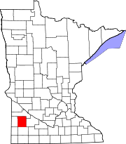
Garden City is an unincorporated community and census-designated place (CDP) in Garden City Township, Blue Earth County, Minnesota, United States. Its population was 255 as of the 2010 census.

Miloma is an unincorporated community located in Jackson County, Minnesota, United States at latitude 43.763 and longitude -95.368. The elevation is 1,427 feet. Miloma appears on the Heron Lake U.S. Geological Survey Map.
Imogene is an unincorporated community located in Martin County in the U.S. state of Minnesota. The elevation is 1,129 feet. Imogene appears on the Granada U.S. Geological Survey Map.

Lake Tomahawk is an unincorporated census-designated place located in the town of Lake Tomahawk, Oneida County, Wisconsin, United States. Lake Tomahawk is located on Wisconsin Highway 47 15 miles (24 km) northwest of Rhinelander. Lake Tomahawk has a post office with ZIP code 54539. As of the 2010 census, its population was 228.
Barronett is an unincorporated census-designated place located in the town of Lakeland, Barron County, Wisconsin, United States. Barronett is located on U.S. Route 63 7.5 miles (12.1 km) north-northeast of Cumberland. Barronett has a post office with ZIP code 54813. As of the 2010 census, its population is 111.
Springbrook is an unincorporated community and census-designated place located in the town of Springbrook, Washburn County, Wisconsin, United States. Springbrook is located on U.S. Route 63 13 miles (21 km) northeast of Spooner. Springbrook has a post office with ZIP code 54875. Its population was 76 in 2017.

Lawrence is an extinct village in section 16 of St. Lawrence Township, Scott County, in the U.S. state of Minnesota. The GNIS classifies it as a populated place.
Blakeley is an unincorporated community in Blakeley Township, Scott County, Minnesota, United States, along the Minnesota River. The community is located west-southwest of Belle Plaine near the junction of Scott County Roads 1, 6, and 60.
Burchard is an unincorporated community in Lyon County, in the U.S. state of Minnesota.
Burr is an unincorporated community in Florida Township, Yellow Medicine County, in the U.S. state of Minnesota.
Cambria is an unincorporated community in Blue Earth County, in the U.S. state of Minnesota.
Dudley is an unincorporated community in Lyon County, in the U.S. state of Minnesota.
Guckeen is an unincorporated community in Faribault County, in the U.S. state of Minnesota.
Judson is an unincorporated community in Blue Earth County, in the U.S. state of Minnesota.
Marna is an unincorporated community in Faribault County, in the U.S. state of Minnesota.
Grogan is an unincorporated community in Watonwan County, in the U.S. state of Minnesota.
Merriam was a town in Scott County, in the U.S. state of Minnesota. The town has since been closed altogether.
Perth is an unincorporated community in Blue Earth County, in the U.S. state of Minnesota.