Russell, Minnesota

Last updated

Russell, Minnesota
Lyon County Minnesota Incorporated and Unincorporated areas Russell Highlighted.svg
Location of Russell, Minnesota
Coordinates: 44°19′12″N95°56′51″W / 44.32000°N 95.94750°W / 44.32000; -95.94750
Country United States
State Minnesota
County Lyon
Government
  TypeMayor Council
  MayorRoger Hook[ citation needed ]
Area
[1]
  Total0.97 sq mi (2.52 km2)
  Land0.92 sq mi (2.38 km2)
  Water0.05 sq mi (0.14 km2)
Elevation
[2]
1,519 ft (463 m)
Population
 (2020)
  Total348
  Density379.08/sq mi (146.43/km2)
Time zone UTC-6 (Central (CST))
  Summer (DST) UTC-5 (CDT)
ZIP code
56169
Area code 507
FIPS code 27-56428 [3]
GNIS feature ID2396455 [2]

Russell is a city in Lyon County, Minnesota, United States. The population was 348 at the 2020 census. [4]

Contents

History

Russell was platted in 1888, and named for Russell Spicer, the son of the settler credited with bringing the railroad to the community. [5] A post office has been in operation at Russell since 1889. [6] Russell was incorporated in 1898. [5]

Geography

According to the United States Census Bureau, the city has a total area of 0.97 square miles (2.51 km2), of which 0.91 square miles (2.36 km2) is land and 0.06 square miles (0.16 km2) is water. [7]

The Redwood River flows through the city. [8]

Minnesota State Highways 23 and 91 are two of the main routes in the community.

Demographics

Historical population
CensusPop.Note
1910 262
1920 37543.1%
1930 358−4.5%
1940 46429.6%
1950 5089.5%
1960 449−11.6%
1970 398−11.4%
1980 4123.5%
1990 394−4.4%
2000 371−5.8%
2010 338−8.9%
2020 3483.0%
U.S. Decennial Census [9]

2010 census

As of the census [10] of 2010, there were 338 people, 157 households, and 86 families residing in the city. The population density was 371.4 inhabitants per square mile (143.4/km2). There were 175 housing units at an average density of 192.3 per square mile (74.2/km2). The racial makeup of the city was 98.5% White, 1.2% African American, and 0.3% Native American. Hispanic or Latino of any race were 0.6% of the population.

There were 157 households, of which 27.4% had children under the age of 18 living with them, 48.4% were married couples living together, 5.1% had a female householder with no husband present, 1.3% had a male householder with no wife present, and 45.2% were non-families. 38.2% of all households were made up of individuals, and 17.9% had someone living alone who was 65 years of age or older. The average household size was 2.15 and the average family size was 2.94.

The median age in the city was 37.7 years. 24.9% of residents were under the age of 18; 4% were between the ages of 18 and 24; 29.6% were from 25 to 44; 22.4% were from 45 to 64; and 18.9% were 65 years of age or older. The gender makeup of the city was 48.5% male and 51.5% female.

2000 census

As of the census [3] of 2000, there were 371 people, 157 households, and 105 families residing in the city. The population density was 415.0 inhabitants per square mile (160.2/km2). There were 170 housing units at an average density of 190.2 per square mile (73.4/km2). The racial makeup of the city was 99.19% White, 0.27% African American, 0.54% from other races. Hispanic or Latino of any race were 3.50% of the population.

There were 157 households, out of which 33.8% had children under the age of 18 living with them, 56.1% were married couples living together, 5.7% had a female householder with no husband present, and 33.1% were non-families. 25.5% of all households were made up of individuals, and 14.0% had someone living alone who was 65 years of age or older. The average household size was 2.36 and the average family size was 2.90.

In the city, the population was spread out, with 25.1% under the age of 18, 9.2% from 18 to 24, 29.4% from 25 to 44, 16.2% from 45 to 64, and 20.2% who were 65 years of age or older. The median age was 35 years. For every 100 females, there were 103.8 males. For every 100 females age 18 and over, there were 95.8 males.

The median income for a household in the city was $32,045, and the median income for a family was $39,000. Males had a median income of $32,188 versus $21,406 for females. The per capita income for the city was $14,767. About 6.1% of families and 9.8% of the population were below the poverty line, including 5.3% of those under age 18 and 14.9% of those age 65 or over.

Related Research Articles

<span class="mw-page-title-main">Chickamaw Beach, Minnesota</span> City in Minnesota, United States

Chickamaw Beach is a city in Cass County, Minnesota, United States. The population was 128 at the 2020 census. It is part of the Brainerd Micropolitan Statistical Area.

<span class="mw-page-title-main">Lake Shore, Minnesota</span> City in Minnesota, United States

Lake Shore is a city in Cass County, Minnesota, United States. The population was 1,056 at the 2020 census. It is part of the Brainerd Micropolitan Statistical Area.

<span class="mw-page-title-main">Fort Ripley, Minnesota</span> City in Minnesota, United States

Fort Ripley is a city in Crow Wing County, Minnesota, United States, near the confluence of the Mississippi and Nokasippi Rivers. The population was 69 at the 2010 census. It is part of the Brainerd Micropolitan Statistical Area.

Randolph Township is a township in Dakota County, Minnesota, United States. The population was 536 at the 2000 census.

<span class="mw-page-title-main">Garfield, Minnesota</span> City in Minnesota, United States

Garfield is a city in Douglas County, Minnesota, United States. The population was 349 at the 2020 census.

<span class="mw-page-title-main">Kensington, Minnesota</span> City in Minnesota, United States

Kensington is a city in Douglas County, Minnesota, United States. The population was 266 at the 2020 census. The city is notable in Minnesota history for being the place where the Kensington Runestone was first displayed. It is now at a museum in nearby Alexandria, Minnesota.

<span class="mw-page-title-main">Canton, Minnesota</span> City in Minnesota, United States

Canton is a city in Fillmore County, Minnesota, United States. The population was 346 at the 2010 census.

<span class="mw-page-title-main">Hoffman, Minnesota</span> City in Minnesota, United States

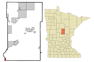
Hoffman is a city in Grant County, Minnesota, United States, along the Chippewa River. The population was 681 at the 2010 census.

<span class="mw-page-title-main">Corcoran, Minnesota</span> City in Minnesota, United States

Corcoran is a rural city in Hennepin County, Minnesota, United States. The population was 5,379 at the 2010 census.

<span class="mw-page-title-main">Blomkest, Minnesota</span> City in Minnesota, United States

Blomkest is a city in Kandiyohi County, Minnesota, United States. The population was 157 at the 2010 census.

Kilkenny Township is a township in Le Sueur County, Minnesota, United States. The population was 393 at the 2000 census.

<span class="mw-page-title-main">Lynd, Minnesota</span> City in Minnesota, United States

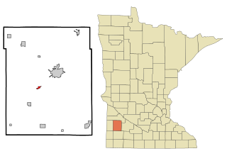
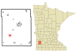
Lynd is a city in Lyon County, Minnesota, United States. The population was 448 at the 2010 census. Lynd is a small but growing community in southwestern Minnesota. The development of a new golf course and an additional housing development have started a growth trend that may eventually double the size of the community. It is primarily a bedroom community for individuals who work in the nearby city of Marshall. Despite being much smaller in size, it historically played a more significant role in the area. The Kiel and Morgan Hotel in the town was the original Lyon County seat.

<span class="mw-page-title-main">Swanville, Minnesota</span> City in Minnesota, United States

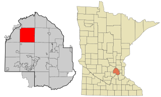
Swanville is a city in Morrison County, Minnesota, United States. A very small portion of the city extends into Todd County. The population was 326 at the 2020 census.

<span class="mw-page-title-main">Racine, Minnesota</span> City in Minnesota, United States

Racine is a city in Mower County, Minnesota, United States. The population was 458 at the 2020 census.

<span class="mw-page-title-main">Henning, Minnesota</span> City in Minnesota, United States

Henning is a city in Otter Tail County, Minnesota, United States. The population was 854 at the 2020 census.

Sandstone Township is a township in Pine County, Minnesota, United States. The population was 1,614 at the 2000 census.

<span class="mw-page-title-main">Cyrus, Minnesota</span> City in Minnesota, US

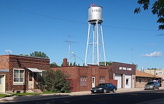
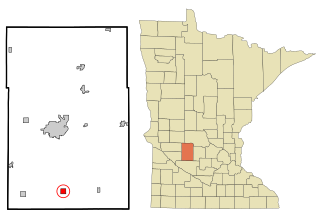
Cyrus is a city in Pope County, Minnesota, United States, along the Chippewa River. The population was 305 at the 2020 census.

<span class="mw-page-title-main">Wanda, Minnesota</span> City in Minnesota, United States

Wanda is a city in Redwood County, Minnesota, United States. The population was 84 at the 2010 census.

<span class="mw-page-title-main">Hoyt Lakes, Minnesota</span> City in Minnesota, United States

Hoyt Lakes is a city in Saint Louis County, Minnesota. The population was 2,020 at the time of the 2020 census.

<span class="mw-page-title-main">Minnesota Lake, Minnesota</span> City in Minnesota, United States

Minnesota Lake is a city in Blue Earth and Faribault counties in the State of Minnesota. The population was 661 at the 2020 census. The bulk of the city is in Faribault County; a small part extends into Blue Earth County.

References

  1. "2020 U.S. Gazetteer Files". United States Census Bureau. Retrieved July 24, 2022.
  2. 1 2 U.S. Geological Survey Geographic Names Information System: Russell, Minnesota
  3. 1 2 "U.S. Census website". United States Census Bureau . Retrieved January 31, 2008.
  4. "Explore Census Data". data.census.gov. Retrieved June 6, 2024.
  5. 1 2 Upham, Warren (1920). Minnesota Geographic Names: Their Origin and Historic Significance. Minnesota Historical Society. p.  314.
  6. "Lyon County". Jim Forte Postal History. Retrieved July 18, 2015.
  7. "US Gazetteer files 2010". United States Census Bureau. Archived from the original on July 2, 2012. Retrieved November 13, 2012.
  8. Minnesota Atlas & Gazetteer. Yarmouth, Me.: DeLorme. 1994. p. 28. ISBN   0-89933-222-6.
  9. "Census of Population and Housing". Census.gov. Retrieved June 4, 2015.
  10. "U.S. Census website". United States Census Bureau . Retrieved November 13, 2012.