Lynd, Minnesota | |
---|---|
Nickname: Lindia | |
Coordinates: 44°23′49″N95°52′53″W / 44.39694°N 95.88139°W | |
Country | United States |
State | Minnesota |
County | Lyon |
Government | |
• Type | Mayor – Council |
• Mayor | Justin Guggisburg [ citation needed ] |
Area | |
• Total | 1.17 sq mi (3.02 km2) |
• Land | 1.16 sq mi (3.00 km2) |
• Water | 0.01 sq mi (0.02 km2) |
Elevation | 1,289 ft (393 m) |
Population (2020) | |
• Total | 436 |
• Density | 376.84/sq mi (145.51/km2) |
Time zone | UTC-6 (Central (CST)) |
• Summer (DST) | UTC-5 (CDT) |
ZIP code | 56157 |
Area code | 507 |
FIPS code | 27-38708 [3] |
GNIS feature ID | 2395791 [2] |
Lynd is a city in Lyon County, Minnesota, United States. The population was 448 at the 2010 census. [4] Lynd is a small but growing community in southwestern Minnesota. The development of a new golf course and an additional housing development have started a growth trend that may eventually double the size of the community. It is primarily a bedroom community for individuals who work in the nearby city of Marshall. Despite being much smaller in size, it historically played a more significant role in the area. The Kiel and Morgan Hotel in the town was the original Lyon County seat.
Lynd was platted in 1888. [5] The city's namesake is state senator James Lynd, who was killed in the Attack at the Lower Sioux Agency. [5]
According to the United States Census Bureau, the city has a total area of 1.19 square miles (3.08 km2), of which 1.17 square miles (3.03 km2) is land and 0.02 square miles (0.05 km2) is water. [6]
The Redwood River flows through the city. [7]
Minnesota State Highway 23 serves as a main route in the community.
Census | Pop. | Note | %± |
---|---|---|---|
1960 | 259 | — | |
1970 | 267 | 3.1% | |
1980 | 304 | 13.9% | |
1990 | 287 | −5.6% | |
2000 | 346 | 20.6% | |
2010 | 448 | 29.5% | |
2020 | 436 | −2.7% | |
U.S. Decennial Census |
As of the census [8] of 2010, there were 448 people, 164 households, and 119 families living in the city. The population density was 382.9 inhabitants per square mile (147.8/km2). There were 184 housing units at an average density of 157.3 per square mile (60.7/km2). The racial makeup of the city was 83.0% White, 2.0% African American, 0.9% Native American, 0.9% Asian, 10.5% from other races, and 2.7% from two or more races. Hispanic or Latino of any race were 19.0% of the population.
There were 164 households, of which 42.1% had children under the age of 18 living with them, 56.1% were married couples living together, 11.6% had a female householder with no husband present, 4.9% had a male householder with no wife present, and 27.4% were non-families. 23.2% of all households were made up of individuals, and 4.2% had someone living alone who was 65 years of age or older. The average household size was 2.73 and the average family size was 3.25.
The median age in the city was 34.2 years. 31.7% of residents were under the age of 18; 6.5% were between the ages of 18 and 24; 28.4% were from 25 to 44; 25.8% were from 45 to 64; and 7.6% were 65 years of age or older. The gender makeup of the city was 50.9% male and 49.1% female.
As of the census [3] of 2000, there were 346 people, 130 households, and 80 families living in the city. The population density was 826.1 inhabitants per square mile (319.0/km2). There were 134 housing units at an average density of 319.9 per square mile (123.5/km2). The racial makeup of the city was 89.02% White, 0.58% African American, 0.29% Native American, 1.45% Asian, 6.36% from other races, and 2.31% from two or more races. Hispanic or Latino of any race were 14.16% of the population.
There were 130 households, out of which 33.8% had children under the age of 18 living with them, 50.0% were married couples living together, 6.2% had a female householder with no husband present, and 37.7% were non-families. 23.8% of all households were made up of individuals, and 9.2% had someone living alone who was 65 years of age or older. The average household size was 2.66 and the average family size was 3.20.
In the city, the population was spread out, with 27.2% under the age of 18, 12.7% from 18 to 24, 30.9% from 25 to 44, 18.5% from 45 to 64, and 10.7% who were 65 years of age or older. The median age was 33 years. For every 100 females, there were 119.0 males. For every 100 females age 18 and over, there were 119.1 males.
The median income for a household in the city was $36,125, and the median income for a family was $36,458. Males had a median income of $26,635 versus $20,313 for females. The per capita income for the city was $15,026. About 14.7% of families and 15.7% of the population were below the poverty line, including 23.9% of those under age 18 and none of those age 65 or over.
East Bethel is a city in Anoka County, Minnesota, United States. The population was 11,786 at the 2020 census.
Mapleton is a city in Blue Earth County, Minnesota, United States. The population was 1,710 at the 2020 census. It is part of the Mankato-North Mankato Metropolitan Statistical Area.
Deerwood is a city in Crow Wing County, Minnesota, United States. The population was 526 at the 2020 census. It is part of the Brainerd Micropolitan Statistical Area.
Minnetrista is a city in Hennepin County, Minnesota, United States. Largely rural, Minnetrista has agricultural activity involving corn, soybeans, hay and horses. In addition to farmland and woods, the city is home to several lakes, including part of Lake Minnetonka, the state's ninth-biggest.
Keewatin is a city in Itasca County, Minnesota, United States. The population was 1,068 at the 2010 census.
Lakefield is a city in Jackson County, Minnesota, United States. The population was 1,694 at the 2010 census.
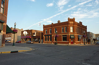
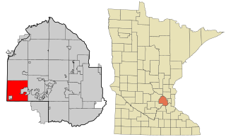
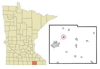
Le Center is a city in Le Sueur County, Minnesota, United States. The population was 2,517 at the 2020 census. It is the county seat of Le Sueur County. The Le Sueur County Courthouse and Jail are listed on the National Register of Historic Places.
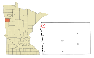
Lynd Township is a township in Lyon County, Minnesota, United States. The population was 471 at the 2000 census.
Plato is a city in eastern McLeod County, Minnesota, United States. The population was 320 at the 2010 census.
Brownsdale is a city in Red Rock Township, Mower County, Minnesota, United States. The population was 676 at the 2010 census.
Shelly is a city in Norman County, Minnesota, United States. The population was 179 at the 2020 census.
Bluffton is a city in Otter Tail County, Minnesota, United States, along the Leaf River. The population was 210 at the 2020 census.
Gully is a city in Polk County, Minnesota, United States. It is part of the Grand Forks-ND-MN Metropolitan Statistical Area. The population was 59 at the 2020 census.
McIntosh is a city in Polk County, Minnesota, United States. It is part of the Grand Forks, ND-MN Metropolitan Statistical Area. The population was 606 at the 2020 census.
Fairfax is a city in Renville County, Minnesota, United States. The population was 1,235 at the 2010 census.
Gilbert is a city in St. Louis County, Minnesota, United States. The population was 1,799 at the 2010 census. State Highway 37 and State Highway 135 are two of the main routes in Gilbert. Gilbert is part of the Quad Cities, with Virginia, Eveleth, and Mountain Iron. The city is named for Giles Gilbert, who led the exploration of the McKinley mine property in the 1890s.
Bertha is a city in Todd County, Minnesota, United States. The population was 497 at the 2010 census.
Maple Lake is a city in Wright County, Minnesota, United States. The population was 2,159 at the 2020 census. Minnesota State Highway 55 serves as a main route in the city.
Battle Lake is a city in Otter Tail County, Minnesota, United States. The population was 857 according to the 2020 census.
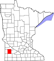
Ormsby is a city in Martin and Watonwan counties in the U.S. state of Minnesota. The population was 131 at the 2010 census.