Auckland Botanic Gardens

Last updated

Auckland Botanic Gardens
Visitor Centre .jpg
Auckland Botanic Gardens Visitor Centre
Auckland Botanic Gardens
TypeBotanic Garden
Location Manurewa, Auckland, New Zealand
Coordinates 37°00′47″S174°54′27″E / 37.0130°S 174.9075°E / -37.0130; 174.9075
Area64 hectares (160 acres)
CreatedFebruary 23, 1982 (1982-02-23)
Operated by Auckland Council
Visitors1+ million (approx. per year)
Website www.aucklandbotanicgardens.co.nz

Auckland Botanic Gardens is a botanical garden in the New Zealand city of Auckland. It is located in the suburb of Manurewa, in the Manurewa Local Board Area. The garden covers 64 hectares (160 acres), and holds more than 10,000 plants. [1]

Contents

Land for the garden was purchased in 1968, developments started in 1973 and the garden opened to the public in 1982. Since its establishment, the garden has been owned and operated by Auckland Council and its predecessors Auckland Regional Authority and Auckland Regional Council. [2]

Location

The Auckland Botanic Gardens is the site of the former Nathan family estate established in 1910, where David Lawrence Nathan constructed a large summer house at the property, which he referred to as "The Hill". By 1920, the family made the estate their permanent home. In 1923, a fire demolished the homestead, which was replaced with a brick Basque-inspired building in 1925, designed by D. B. Patterson. [3]

During the second world war, two military camps were established at the estate: Top Camp and Grande Vue Camp, both occupied by American marines on rest duty, and later by New Zealand troops. After the end of the war and the sudden death of David Nathan, his wife Simone Nathan decided to move to Israel, and rented the estate. [3] During the construction of the Auckland Southern Motorway, the section of the estate to the west of the new road was subdivided, and became the suburb of Hillpark. [3] The family ran the estate as a farm, until the land was sold to establish the Auckland Botanic Gardens. [3]

Adjacent to the 64 ha (160 acres) gardens is Totara Park, a 216 ha (530 acres) nature reserve managed by the Auckland Council. The park includes areas of regenerating native bush, recreational spaces and farmland. [4]

History of the gardens

1926–1968

The first concept for a botanical garden in the Auckland region started in 1926, when members of the Auckland District Horticultural Society suggested such an attraction for Auckland. [5] In October, 1928, a report was forwarded to the then Parks Committee of the City Council with recommendations. This was approved by the committee. The committee recommended to put aside part of the Auckland Domain for the purpose. "Since then, very little further has been done". [6] In 1945, Churchill Park was considered. [7]

In the 1950s many sites were investigated for housing a botanic garden. [8] In 1957 V. J. Chapman, professor of botany at Auckland University College, drew attention to the fact that Auckland, alone among New Zealand's chief cities, had no botanic garden. He pointed out that the city could acquire 80 acres (320,000 m2) of land at the Tamaki property of the university. [6]

In 1960 an ad hoc committee was formed to try to find a suitable site and to secure its development as a botanic garden. In 1963, it became clear that land at Tamaki was not feasible. The search continued. In 1964, an area of land in the Manurewa suburb was examined with positive results. [7]

1968–1989

On 9 February 1968 the Auckland Regional Authority acquired 42 hectares of land from the Nathan Estate in Manurewa, and the Manukau City Council bought the remaining 40 hectares of the estate, since the property was offered as a whole. [9] The land was leased for grazing until 1970. Soil tests were carried out. These proved that the area was most suitable for a botanic garden. [7]

A scientific advisory committee prepared the first master plan for the gardens. This was adopted by Council in March 1972. On 19 February 1973 the then Auckland City Councillor, Tom Pearce, turned the first sod. A nursery was established at the eastern end of the Hill Road frontage.

In 1982 the Auckland Regional Authority bought approximately 20.5 ha from Manukau City and accepted from it a gift of 2.2 ha to give the gardens a northern frontage onto Orams Road.

23 February 1982 the gardens were officially opened by David Bellamy. At that time the facilities included a visitor centre, the courtyard, the carpark and public toilets. The plant collections were confined to the southern parts of the gardens.

In 1983 the Sir John Logan Campbell Lecture Building was erected. In 1986 an entrance at Katote Place was constructed in memory of Mr. Harry Beaumont, a former member of both the Auckland Regional Authority and Manukau City Council, and a strong promoter of the establishment of the gardens. That same year the Unitec Horticultural Classroom and an associated demonstration home garden were opened. [9]

A review of the role and activities of the gardens was undertaken in 1988–89 by a working party. [10]

1990–present

In the early 1990s a covered courtyard and the Friends Horticultural Reference library were opened. Redevelopment of garden collections were undertaken in the 2000s such as the Heritage Rose Garden, New Zealand Rose Garden and the South African garden. A new significant addition to the garden was the opening of the Threatened Native Plant Garden by the Prime Minister Helen Clark on 29 September 2001. This was followed by another significant development of a new Children's Garden, formally opened by the Prince of Wales on 10 March 2005. On the same year a new Visitor Centre building was constructed and opened.

A biennial sculpture exhibition (Sculpture in the Gardens), showcasing selected large-scale public sculptures, commenced in 2007 running for 3 months over the summer season. Another round of garden redevelopment occurred in the late 2000s with a major revamp of the Edible Gardens into themed rooms and a second stage added to the Children's Garden. From 2010 onwards, a series of low-impact and water treatment/ stormwater design initiatives were added around the garden such as two living roof buildings, vegetated swales, rain gardens and riparian planting around the central lakes.

This location was also used in television series Power Rangers Dino Charge , turned into Amber Beach Dinosaur Museum and later in 2016 changed to Amber Beach Dinosaur Zoo.

Numbers of visitors

In the first years after the opening in February 1982, visitor numbers were relatively stable at around 100,000 visits per annum. 1988: 143,000. [11] From 1988 to 1994 a rapid increase took place (numbers counted over the season July to June):. [12]

1988/9157,959
1993/4494,634

Annual visitation to the gardens reached 969,000 people in 2009/2010 and has increased to around one million people each year ever since.

Mission

The mission of Auckland Botanic Gardens is threefold: [13]

Research

Research in the Botanic Gardens has been mainly directed on identifying plants that are best suited to growing in local conditions. Three panels have been active, on natives, on trees and shrubs, and on bulbs and perennials. As a result of this research a great number of Advisory Leaflets was published, together forming the dossier "Gardening in Auckland – Horticultural advice for Auckland gardeners" (published regularly since 1981), freely available at the visitor centre. Much of the trials have been conducted in the Shrub Trial Garden. Here some extensive collections have been created of Hydrangea , azalea, Deutzia and other genera. Nowadays the advisory work is still continued and the Advisory Leaflets are still updated regularly. [14]

Plant conservation

Auckland Botanic Gardens holds plants from both New Zealand and elsewhere in the world which are threatened with extinction. There are also collections of plant cultivars which are now uncommon in cultivation. Growing these plants enables the gardens to provide plant material for research, education, cultivation and reintroduction back into the wild or commercial horticulture.

The gardens take an active role in plant conservation of threatened New Zealand native plants. A good example is the shore spurge Euphorbia glauca or kakabeak Clianthus puniceus .

Collection

Reflective Rose Garden showcasing climbing roses Relective Rose Garden 2009.jpg
Reflective Rose Garden showcasing climbing roses

Important collections of the Auckland Botanic Gardens include:

- The New Zealand Native Plant Identification Trail: a short walk highlighting characteristics of a selection of NZ native plants
- The Native Forest Trail: a marked walk that leads through a broadleaf/podocarp forest remnant with a total of about 30 hectares. 10 hectares are part of and managed by the Botanic Gardens. 20 hectares are part of 'Totara Park', managed by the Manukau City Council. The area was cut in earlier times to harvest timber. The forest is now regenerating. There are a number of tracks in the area. One of the tracks is described in a leaflet with information on plants and trees. The flora of the combined area consists of 158 species in total. [15]
- The Harakeke ( Phormium ) Collection, with a large number of cultivars traditionally used by Maori for weaving.
- The Threatened Native Plant Collection, opened 2001 by Helen Clark, ex-Prime Minister of New Zealand. Here we find for instance fine specimen of Three Kings (Trumpet) Vine Tecomanthe speciosa and of Shore Spurge.
- Native Plant Ideas: ornamental native plants combined in creatively designed gardens.

There are a number of other smaller collections, for instance a collection of conifers, with a specimen of Keteleeria davidiana and Bishop Pine Pinus muricata.

The database, that lists all the plants in the collections, is available for consultation in the Visitor Centre.

Visitor centre Auckland Botanic Gardens.jpg
Visitor centre
Interior of the library AucklandBGLibrary.jpg
Interior of the library

Visitor Centre

The Visitor Centre Huakaiwaka is a modern building opened in 2005 that houses the information desk, information displays, a café, and offices.

Library

The Horticultural Reference Library is housed in a separate building. The building was opened in 1992 and was funded by the Friends of the Auckland Botanic Gardens. It contains some 2,500 books and a number of horticultural journals and magazines. The catalogue holds about 10,000 items. [14] The library is open to the public.

The huge impact of the activities of the Friends is clearly demonstrated by the fact that in 1989 the library housed only 400 volumes in the Information Centre, that were solely used for reference by staff. [16]

Ellerslie Flower Show

The Ellerslie Flower Show was a very successful event which eventually outgrew its original location at the Ellerslie Race Course. The Botanic Gardens were used for the show for a number of years until 2008, when it moved to Hagley Park in Christchurch.

Footnotes

  1. Auckland Regional Council, Parks Service 1995, p. 7
  2. An. 1982
  3. 1 2 3 4 Wichman, Gwen (2001). Soaring Bird: a History of Manurewa to 1965. Manurewa: Manurewa Historical Society. p. 92-94. ISBN   0-473-07114-2. Wikidata   Q117421984.
  4. Janssen, Peter (January 2021). Greater Auckland Walks. New Holland Publishers. p. 177-178. ISBN   978-1-86966-516-6. Wikidata   Q118136068.
  5. Higham 1993, p. 91. See also Chapman 1972 ("April, 1926"). Chapman 1957 dates the first proposals back to 1927
  6. 1 2 Chapman 1957
  7. 1 2 3 Chapman 1972
  8. Higham 1993, p. 91 says 1953. Chapman 1972 says between 1954 and 1959
  9. 1 2 Auckland Regional Council, Parks Service 1975, p. 20
  10. Auckland Regional Authority, Regional Parks Department 1989
  11. Auckland Regional Authority, Regional Parks Department 1989, p. 16
  12. Auckland Regional Council, Parks Service 1995, p. 25
  13. Vision as stated on the website of the gardens
  14. 1 2 verbal information by librarian 2008-11-10; see also: History of ARBG (Auckland Regional Botanic Gardens → nowadays: Auckland BG) Plant Evaluation Panels & Advisory Leaflets
  15. Auckland Regional Council, Parks Service 1995, p. 12
  16. Auckland Regional Authority, Regional Parks Department 1989, p. 38

Related Research Articles

<span class="mw-page-title-main">Manukau City</span> Territorial authority of New Zealand in North Island

Manukau City was a territorial authority district in Auckland, New Zealand, that was governed by the Manukau City Council. The area is also referred to as "South Auckland", although this term never possessed official recognition and does not encompass areas such as East Auckland, which was within the city boundary. It was a relatively young city, both in terms of legal status and large-scale settlement – though in June 2010, it was the third largest in New Zealand, and the fastest growing. In the same year, the entire Auckland Region was amalgamated under a single city authority, Auckland Council.

<span class="mw-page-title-main">Arboretum</span> Botanical collection composed exclusively of trees

An arboretum is a botanical collection composed exclusively of trees of a variety of species. Originally mostly created as a section in a larger garden or park for specimens of mostly non-local species, many modern arboreta are in botanical gardens as living collections of woody plants and are intended at least in part for scientific study.

<span class="mw-page-title-main">South Auckland</span> Region of Auckland, New Zealand

South Auckland ) is one of the major geographical regions of Auckland, the largest city in New Zealand. The area is south of the Auckland isthmus, and on the eastern shores of the Manukau Harbour. The area has been populated by Tāmaki Māori since at least the 14th century, and has important archaeological sites, such as the Ōtuataua stonefield gardens at Ihumātao, and Māngere Mountain, a former pā site important to Waiohua tribes.

<span class="mw-page-title-main">Manurewa</span> Suburb in Auckland, New Zealand

Manurewa is a major suburb in South Auckland, New Zealand, located 6 km (3.7 mi) south of Manukau Central, and 26 km (16 mi) southeast of the Auckland City Centre. It is home to the Auckland Botanic Gardens, which receives over a million visitors a year. Manurewa has a high proportion of non-European ethnicities, making it one of the most multi-cultural suburbs in New Zealand. Employment for many is at the many companies of nearby Wiri, Papakura, and at the steel mill at Glenbrook.

<span class="mw-page-title-main">VanDusen Botanical Garden</span>

VanDusen Botanical Garden is a botanical garden situated in Vancouver, British Columbia, in the Shaughnessy neighborhood. It is located at the northwest corner of 37th Avenue and Oak Street. It is named for local lumberman and philanthropist Whitford Julian VanDusen.

<span class="mw-page-title-main">New England Botanic Garden</span> Botanic garden in Boylston, Massachusetts

New England Botanic Garden at Tower Hill is a 200-acre four season botanic garden located in Boylston, Massachusetts, approximately 10 miles (16 km) north of central Worcester in Worcester County, Massachusetts. The Garden features 18 distinct garden spaces, preserved woodlands, and miles of walking trails. More than 200,000 thousand people visit New England Botanic Garden at Tower Hill each year to explore gardens and conservatories that showcase diverse collections of native, ornamental, tropical, rare, and edible plants.

<span class="mw-page-title-main">Christchurch Botanic Gardens</span> Botanical gardens in New Zealand

The Christchurch Botanic Gardens, located in the central city of Christchurch, New Zealand, were founded in 1863 when an English oak was planted to commemorate the solemnisation of the marriage of Prince Albert and Princess Alexandra of Denmark. The gardens sprawl over an area of 21 hectares and lie adjacent to the loop of the Avon River next to Hagley Park. The Christchurch Botanic Gardens have a variety of collections of exotic and local plants of New Zealand, several conservatories, a nursery, playground and Climatological Station.

<span class="mw-page-title-main">Michigan State University Horticulture Gardens</span> Botanical garden in East Lansing, Michigan

The Michigan State University Horticulture Gardens are horticultural gardens, with a landscape arboretum, located on Bogue Street on the Michigan State University campus in East Lansing, Michigan. The gardens are open to the public daily without charge.

<span class="mw-page-title-main">Māngere Mountain</span> Volcanic cone in Auckland, New Zealand

Māngere Mountain, also known by the names Te Pane-o-Mataaho and Te Ara Pueru, is a volcanic cone in Māngere, Auckland. Located within Māngere Domain, it is one of the largest volcanic cones in the Auckland volcanic field, with a peak 106 metres (348 ft) above sea level. It was the site of a major pā and many of the pā's earthworks are still visible. It has extensive panoramic views of Auckland from its location in the southeastern portion of the city's urban area.

<span class="mw-page-title-main">Hamilton Gardens</span> Garden park in Hamilton, New Zealand

Hamilton Gardens is a public garden park in the south of Hamilton owned and managed by Hamilton City Council in New Zealand. The 54-hectare park is based on the banks of the Waikato River and includes enclosed gardens, open lawns, a lake, a nursery, a convention centre and the Hamilton East Cemetery. It is the Waikato region's most popular visitor attraction, attracting more than 1 million people and hosting more than 2,000 events a year.

<span class="mw-page-title-main">Regional parks of New Zealand</span>

Regional parks of New Zealand are protected areas administered by regional councils, the top tier of local government. Regional parks are found across five regions of New Zealand: the Auckland Region, Waikato Region, Bay of Plenty Region, Wellington Region and Canterbury Region. Regional parks in the Auckland and Waikato regions are administered by the Auckland Council, while parks in other areas are administered by regional councils: the Bay of Plenty Regional Council, Greater Wellington Regional Council, and Canterbury Regional Council.

<span class="mw-page-title-main">Otari-Wilton's Bush</span> Botanic garden in Wellington, New Zealand

Ōtari-Wilton's Bush is a native botanic garden and forest reserve located in Wilton in Wellington, New Zealand. It is New Zealand's only public botanic garden dedicated solely to the native plants of New Zealand.

<i>Ulmus</i> Louis van Houtte Elm cultivar

Ulmus 'Louis van Houtte' is believed to have been first cultivated in Ghent, Belgium circa 1863. It was first mentioned by Franz Deegen in 1886. It was once thought a cultivar of English Elm Ulmus minor 'Atinia', though this derivation has long been questioned; W. J. Bean called it "an elm of uncertain status". Its dissimilarity from the type and its Belgian provenance make the 'Atinia' attribution unlikely. Fontaine (1968) considered it probably a form of U. × hollandica.

<span class="mw-page-title-main">Wattle Downs</span> Suburb in Auckland, New Zealand

Wattle Downs is a suburb of Auckland, New Zealand.

<span class="mw-page-title-main">Hillpark, Auckland</span> Suburb of Auckland, New Zealand

Hillpark is a suburb in Auckland, New Zealand. It is bordered by suburbs of The Gardens on the east and Manurewa on the south. It was formerly part of Manukau City until the 2010 amalgamation of all of Auckland's councils, and is now under the governance of Auckland Council.

<span class="mw-page-title-main">Manurewa (local board area)</span> Local board area in Auckland, New Zealand

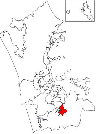
Manurewa is a local government area in Auckland, in New Zealand's Auckland Region. It is governed by the Manurewa Local Board and Auckland Council. It is within the council's Manurewa-Papakura Ward.

<span class="mw-page-title-main">Ambury Regional Park</span>

Ambury Regional Park is a regional park situated on the coast of Manukau Harbour, in Auckland in New Zealand's North Island. It is situated in the suburb of Māngere Bridge and in the local board area of Māngere-Ōtāhuhu, to the west of Māngere Mountain.

<span class="mw-page-title-main">Mutukāroa / Hamlins Hill Regional Park</span>

Mutukāroa / Hamlins Hill Regional Park is a regional park situated in the Auckland suburb of Penrose in New Zealand's North Island. It is situated in Maungakiekie-Tāmaki, north-east of the Manukau Harbour and west of the Tāmaki River. The park is owned and operated by Auckland Council.

<span class="mw-page-title-main">Papakura Stream</span> Stream in South Auckland, New Zealand

The Papakura Stream, also known as the Papakura Creek, is a major stream in South Auckland, in the Auckland Region of New Zealand's North Island. It flows south-west from near the Brookby to the Pahurehure Inlet of the Manukau Harbour. The stream forms the border between Manurewa and Papakura.

<span class="mw-page-title-main">Puhinui Creek</span> River in Auckland Region, New Zealand

The Puhinui Creek, also known as the Puhinui Stream or Te Puhinui, is a major stream in South Auckland, in the Auckland Region of New Zealand's North Island. It flows westwards from Totara Park through Manukau, then southwest at Wiri to the Manukau Harbour.

References

]