
A swamp is a forested wetland. Swamps are considered to be transition zones because both land and water play a role in creating this environment. Swamps vary in size and are located all around the world. The water of a swamp may be fresh water, brackish water, or seawater. Freshwater swamps form along large rivers or lakes where they are critically dependent upon rainwater and seasonal flooding to maintain natural water level fluctuations. Saltwater swamps are found along tropical and subtropical coastlines. Some swamps have hammocks, or dry-land protrusions, covered by aquatic vegetation, or vegetation that tolerates periodic inundation or soil saturation. The two main types of swamp are "true" or swamp forests and "transitional" or shrub swamps. In the boreal regions of Canada, the word swamp is colloquially used for what is more formally termed a bog, fen, or muskeg. Some of the world's largest swamps are found along major rivers such as the Amazon, the Mississippi, and the Congo.

Farewell Spit is a narrow sand spit at the northern end of the Golden Bay, in the South Island of New Zealand. The spit includes around 25 kilometres (16 mi) of stable land and another 5 kilometres (3.1 mi) of mobile sand spit running eastwards from Cape Farewell, the northern-most point of the South Island. Farewell Spit is the longest sand spit in New Zealand, and is a legally protected Nature Reserve. The area is designated as a Ramsar wetland site and an East Asian–Australasian Flyway Shorebird Network site. Farewell Spit is administered by the New Zealand Department of Conservation as a seabird and wildlife reserve. Apart from a small area at the base of the spit, it is closed to the public except through organised tours.
Lake Waipori is the smaller and shallower of the pair of lakes located in the wetlands to the south west of Dunedin in New Zealand on the Waipori River. The Waipori River is a major tributary of the Taieri River, and these wetlands form the southern edge of the Taieri Plains.

Lake Wairarapa is a lake at the southern end of the North Island of New Zealand, 50 kilometres (31 mi) east of Wellington. The lake covers an area of 78 km2 (30 sq mi), and at its deepest is 2.5 m (8.2 ft). It is the third largest in the North Island, fractionally smaller than Lake Rotorua. The nearest town to the lake is Featherston, which is located five kilometres from its northern shore.

Manaaki Whenua – Landcare Research is a New Zealand Crown Research Institute whose focus of research is the environment, biodiversity, and sustainability.

Protected areas of New Zealand are areas that are in some way protected to preserve their environmental, scientific, scenic, historical, cultural or recreational value. There are about 10,000 protected areas, covering about a third of the country. The method and aims of protection vary according to the importance of the resource and whether it is publicly or privately owned.

Pterophylla racemosa, known as the kāmahi, is an evergreen tree native to New Zealand. It is part of the Pterophylla genus which mostly includes sub-tropical species, but the kāmahi is found in a variety of climates in New Zealand from coastal areas, to high elevation inland areas.
The Awarua Wetland is a peatland area of 20,000 hectares in the Southland Region of New Zealand. The site, which was initially an area of about 3,556 hectares, was designated as having international significance under the Ramsar Convention in 1976, using the name Waituna Wetlands Scientific Reserve.

The environment of New Zealand is characterised by an endemic flora and fauna which has evolved in near isolation from the rest of the world. The main islands of New Zealand span two biomes, temperate and subtropical, complicated by large mountainous areas above the tree line. There are also numerous smaller islands which extend into the subantarctic. The prevailing weather systems bring significantly more rain to the west of the country. New Zealand's territorial waters cover a much larger area than its landmass and extend over the continental shelf and abyssal plateau in the South Pacific Ocean, Tasman Sea and Southern ocean.
Queen Elizabeth Park is a regional park located on the Kāpiti Coast in New Zealand. The park is managed by the Greater Wellington Regional Council and contains the last area of natural dunes on the Kāpiti Coast. Facilities and attractions at the park include walkways, a restored wetland, a campground, a visitor centre, the Wellington Tramway Museum, and an area for equestrian activities.
The Tasman Accord was signed in 1989 by Tasman Forestry Ltd, environmental groups and the Government. The company agreed to end native forest clearance on its land, protect about 39,000 hectares, and assist with the recovery programme for kokako, as well as other conservation projects.

The Edithvale-Seaford Wetlands is a collection of principally freshwater swamps and marshlands totalling 261 hectares in southeastern Melbourne, Victoria, Australia, about 30 km (19 mi) southeast of Melbourne CBD. It is the largest natural wetland of its type in the Port Phillip and Western Port basins, and is all that remains of the historic Carrum Carrum Swamp, which once covered more than 4,000 hectares from present-day Mordialloc in the north to Frankston in the south.

The Whangamarino Wetland in the Waikato District is the second largest wetland complex of the North Island of New Zealand. Encompassing a total area of more than 7200 hectares, the Department of Conservation Te Papa Atawhai manages 5,923 hectares of peat bog, swamp, mesotrophic lags, open water and river systems listed as a wetland of international importance under the Ramsar Convention. Fish and Game New Zealand are the second largest landowner, managing 748 hectares of the wetland primarily as gamebird hunting habitat.
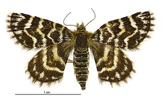
Notoreas hexaleuca is a species of moth in the family Geometridae. This species is endemic to New Zealand.

Notoreas ischnocyma is a species of moth in the family Geometridae. This species is endemic to New Zealand. This species is found in Canterbury and Otago.
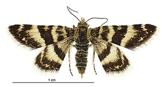
Notoreas ortholeuca is a species of moth in the family Geometridae. It is endemic to New Zealand.

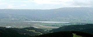
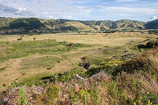
The Wairarapa Moana Wetlands are a major wetland, located in the South Wairarapa District in the Wellington Region at the southern end of New Zealand's North Island.
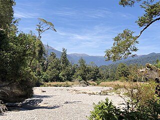
Bullock Creek or Punungairo is a river valley in the Paparoa National Park, located just north of Punakaiki on the West Coast of New Zealand. It includes a rare and nationally significant polje, a large, flat-floored depression within karst limestone. The Bullock Creek polje is New Zealand's only example of this type of landform.
Beverley Rae Clarkson is a New Zealand botanist, ecologist and wetland researcher and conservationist. She is best known for her research into and her conservation work with New Zealand wetlands. In 2021, the city of Hamilton awarded her the Hamilton-Kirikiroa Medal. In the same year Clarkson was awarded the New Zealand conservation award, the Loder Cup.
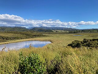
Mangarakau Wetland is in the north-west Tasman District in the South Island of New Zealand. Situated south of the Whanganui Inlet and adjacent to the former settlement of Mangarakau, it is the largest swamp in the Nelson-Marlborough region. It is owned by the Native Forest Restoration Trust and managed by the Friends of Mangarakau Swamp Inc.
