Kaitoke Regional Park

Last updated

Kaitoke Regional Park
Hutt River from flume bridge, Kaitoke.jpg
Hutt River in Kaitoke Regional Park
Kaitoke Regional Park
Type Wellington Regional park
Location Kaitoke, New Zealand
Coordinates 41°04′08″S175°11′55″E / 41.069027°S 175.198658°E / -41.069027; 175.198658
Area2,860 ha (7,100 acres)
Created1983
Operated by Wellington Regional Council
Open6am-6pm (April–September)
6am-9pm (October–March)
StatusOpen

Kaitoke Regional Park is regional park located at Kaitoke, northeast of Upper Hutt, in the Wellington Region of New Zealand's southern North Island. It is administered by Wellington Regional Council, [1] alongside the adjacent Hutt Water Collection Area. [2]

Contents

Geography

The park covers 2,860 ha (7,100 acres) in the Tararua Ranges foothills. The steep hills and Hutt River gorge are covered in native trees. [1]

The conifer-broadleaf rainforest at the fork of Pakuratahi River and Te Awa Kairangi / Hutt River typifies the original vegetation of the area. There is centuries-old rātā, rimu, hinau and kamahi on the upper slopes, red beech on the lower slopes, and black beech on higher spurs and ridge tops with poorer soils. [3]

The forests form an ecological corridor between the Remutaka Ranges and Tararua Ranges, and Pakuratahi and Hutt River catchments. The connected bush provides a habitat for a range of birds and native fish, including tūī, kererū, piwakawaka (fantails), korimako (bellbirds) or miromiro (tomtits). [3]

History

Pre-establishment

Before European settlement, local Māori had established several routes between Wairarapa and Wellington through the Kaitoke area. Whakataka Pā is believed to have established at Te Mārua before 1820. A European road was opened in 1856. [4]

Many of the forests were cleared by early European settlers to provide timber, farm supplies, water and transport routes. Some areas of untouched forest were purchased by local authorities in 1939 for water supplies. [4] Further adjacent land was purchased after World War II, on 20 November 1951, to form Hutt Water Collection Area. [5]

Following the war, the area became a site for picnicking and swimming. In 1976 the Wellington Regional Planning Authority identified the area as a potential regional park because of its native forests and recreational options. [4]

Post-establishment

The park officially opened in 1983. [4] The Wellington Botanical Society and local Upper Hutt branch of Forest and Bird have been involved in protecting and restoring the park. [3]

The park was the filming location for exterior shots of Rivendell for the 2001 movie The Lord of the Rings: The Fellowship of the Ring. [6]

Two people were injured in a plane crash in the regional park in 2016, [7] and one person died in another plane crash in 2020. [8] Toxic algae has remained an ongoing issue in the regional park, with outbreaks in November 2017 and February 2019. [9] [10]

In August 2021, a wheelchair-accessible suspension bridge was opened across Te Awa Kairangi / Hutt River. [11] During the same month, major restoration work began to make the park a carbon sink for the Wellington Region. [12] [13]

Recreation

The park consists mostly native bush, but there are also walking tracks and swimming holes. The most popular loop walk in the park leads through the valley of the upper Te Awa Kairangi / Hutt River. The suspension bridge and some forest tracks are wheelchair accessible. [1] [11]

There are several sites for camping, with drinking water, toilet, power outlet and electric barbecue facilities. Campfires are permitted, but not near riverbeds or tent sites. [1]

As a filming location for The Lord of the Rings: The Fellowship of the Ring, the park also has sightseeing spots and guided tours for Tolkien tourists. [14]

The park opened from 6am to 6pm between April and September, and from 6am to 9pm between October and March. Dogs are permitted, but fireworks are not. [1]

Related Research Articles

<span class="mw-page-title-main">Hutt Valley</span> Valley in Greater Wellington, New Zealand

The Hutt Valley is the large area of fairly flat land in the Hutt River valley in the Wellington region of New Zealand. Like the river that flows through it, it takes its name from Sir William Hutt, a director of the New Zealand Company in early colonial New Zealand.

<span class="mw-page-title-main">Upper Hutt</span> City in Wellington Region, New Zealand

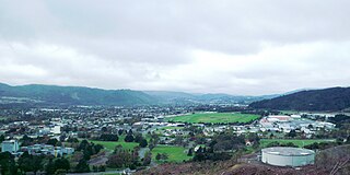
Upper Hutt is a city in the Wellington Region of New Zealand and one of the four cities that constitute the Wellington metropolitan area.

<span class="mw-page-title-main">Hutt River (New Zealand)</span> River in New Zealand

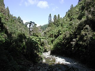
The Hutt River flows through the southern North Island of New Zealand. It flows south-west from the southern Tararua Range for 56 kilometres (35 mi), forming a number of fertile floodplains, including Kaitoke, central Upper Hutt and Lower Hutt.

<span class="mw-page-title-main">Kaitoke</span>

Kaitoke, part of Upper Hutt City, is a locality in the southern North Island of New Zealand. It is located at the northern end of the Hutt Valley, 45 kilometres northeast of Wellington City and six kilometres from the northern end of the Upper Hutt urban area. It also lies at the southern end of the Tararua Ranges.

<span class="mw-page-title-main">Wellington Harbour</span> Harbour in New Zealand

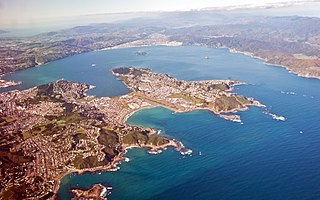
Wellington Harbour, officially called Wellington Harbour / Port Nicholson, is a large natural harbour on the southern tip of New Zealand's North Island. The harbour entrance is from Cook Strait. Central Wellington is located on parts of the western and southern sides of the harbour, and the suburban area of Lower Hutt is to the north and east.

<span class="mw-page-title-main">Miramar, New Zealand</span> Suburb of Wellington City, New Zealand

Miramar is a suburb of Wellington, New Zealand, south-east of the city centre. It is on the Miramar Peninsula, directly east of the isthmus of Rongotai, the site of Wellington International Airport.

<span class="mw-page-title-main">Miramar Peninsula</span> Land in Wellington city, New Zealand

Te Motu Kairangi / Miramar Peninsula is a large peninsula on the southeastern side of the city of Wellington, New Zealand. It is located at the entrance to Wellington Harbour, in Wellington's eastern suburbs. According to Māori legend, it was formed when the taniwha Whaitaitai beached as he tried to escape the confines of the harbour. It contains the suburbs of Miramar, Seatoun, Strathmore Park, and Karaka Bays.

Wellington Regional Council, branded as Greater Wellington Regional Council, is the regional council overseeing the Wellington Region of New Zealand's lower North Island. It is responsible for public transport under the brand Metlink, environmental and flood protection, and the region's water supply. As of 2023, it is the majority owner of CentrePort Wellington with a 77% shareholding.

<span class="mw-page-title-main">Regional parks of New Zealand</span>

Regional parks of New Zealand are protected areas administered by regional councils, the top tier of local government. Regional parks are found across five regions of New Zealand: the Auckland Region, Waikato Region, Bay of Plenty Region, Wellington Region and Canterbury Region. Regional parks in the Auckland and Waikato regions are administered by the Auckland Council, while parks in other areas are administered by regional councils: the Bay of Plenty Regional Council, Greater Wellington Regional Council, and Canterbury Regional Council.

<span class="mw-page-title-main">Lower Hutt</span> City in Wellington, New Zealand

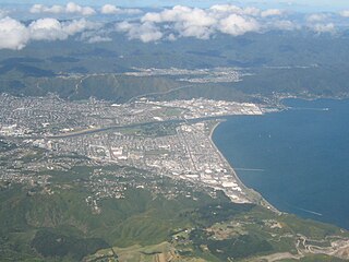
Lower Hutt is a city in the Wellington Region of New Zealand. Administered by the Hutt City Council, it is one of the four cities that constitute the Wellington metropolitan area.

<span class="mw-page-title-main">Battle Hill Farm Forest Park</span>

Battle Hill Farm Forest Park is a regional park near Paekākāriki, in the Kāpiti Coast District and Wellington Region of New Zealand's lower North Island.

<span class="mw-page-title-main">East Harbour Regional Park</span>

East Harbour Regional Park is a regional park stretching from Baring Head along the east side of the Wellington Harbour along the east side of Eastbourne. It is located in Lower Hutt City, in the Wellington Region of New Zealand's North Island.

<span class="mw-page-title-main">Pākuratahi River</span> River in New Zealand

The Pākuratahi River, previously the Pakuratahi River, is a river of the Wellington Region of New Zealand's North Island. It flows northwest from its source in the Remutaka Range 15 kilometres (9 mi) east of Lower Hutt to join the Te Awa Kairangi / Hutt River near Kaitoke.

<span class="mw-page-title-main">Akatarawa Forest</span> Regional park in New Zealand

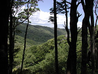
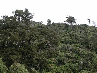
Akatarawa Forest is a regional park in the Upper Hutt within the Wellington Region at the southern tip of the North Island of New Zealand. It encompasses 15,000 hectares of native and plantation forest. It includes the headwaters of the Maungakotukutuku Steam, Akatarawa River West and the Whakatīkei River.

<span class="mw-page-title-main">Hutt Water Collection Area</span> Reserve in Upper Hutt, New Zealand

Hutt Water Collection Area is a reserve located in Upper Hutt in the Wellington Region at the southern end of New Zealand's North Island. It is administered by Wellington Regional Council and is located alongside the larger Kaitoke Regional Park.

<span class="mw-page-title-main">Pākuratahi Forest</span>

Pākuratahi Forest is a regional park located in Upper Hutt in the Wellington Region at the southern end of New Zealand's North Island. It is administered by Wellington Regional Council.

<span class="mw-page-title-main">Wainuiomata Regional Park</span>

Wainuiomata Regional Park is a regional park located near Wainuiomata, Lower Hutt in the Wellington Region of New Zealand. It is administered by Wellington Regional Council. The name of the park was changed from Wainuiomata Recreation Area to Wainuiomata Regional Park in January 2022.

Wainuiomata Water Collection Area is a reserve located near Wainuiomata, Lower Hutt in the Wellington Region at the southern end of New Zealand's North Island. It is administered by Wellington Regional Council, for exclusive use by Wellington Water as a water catchment reserve. The park covers the catchments of the Wainuiomata River and the Ōrongorongo River. It adjoins Remutaka Forest Park and Wainuiomata Regional Park.

<span class="mw-page-title-main">Whitireia Park</span>

Whitireia Park is a headland north of Tītahi Bay and Te Awarua-o-Porirua Harbour in Porirua, in the Wellington Region at the southern end of New Zealand's North Island. It is a park administered by the Whitireia Park Board, in collaboration with Wellington Regional Council. The park includes Onehunga Bay, Kaitawa Point and part of Rocky Bay.

<span class="mw-page-title-main">2022 Wellington local elections</span> Part of the 2022 New Zealand local elections

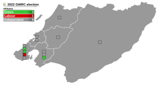
The 2022 Wellington Region local elections were held on 8 October 2022 as part of the wider 2022 New Zealand local elections to elect members to sub-national councils and boards. These elections covered one regional council, eight territorial authorities, and various community boards and licensing trusts.

References

  1. 1 2 3 4 5 "Kaitoke Regional Park". gw.govt.nz. Wellington Regional Council.
  2. "Hutt Water Collection Area". gw.govt.nz. Wellington Regional Council.
  3. 1 2 3 "Environment". gw.govt.nz. Wellington Regional Council.
  4. 1 2 3 4 "History". gwrc.govt.nz. Wellington Regional Council.
  5. Walzl, Tony. "Hutt and Wainuiomata/Orongorongo water collection areas History" (PDF). gwrc.govt.nz. Wellington Regional Council.
  6. "Kaitoke Regional Park, Wellington, New Zealand". www.newzealand.com. Retrieved 21 December 2019.
  7. Weekes, John (2 March 2016). "Two people escape injury as light aircraft damaged in Kaitoke crash". stuff.co.nz. Dominion Post.
  8. Cornish, Sophie (24 November 2016). "Victim of fatal microlight crash near Upper Hutt airfield named". stuff.co.nz. Dominion Post.
  9. Williams, Colin (20 December 2017). "No Christmas cheer for Hutt River users". stuff.co.nz. Dominion Post.
  10. Fallon, Virginia (1 February 2019). "Swimmers warned to take care after toxic algae found in Wellington region's rivers". stuff.co.nz. Dominion Post.
  11. 1 2 "Accessible Suspension Bridge Swings Into Action At Kaitoke Regional Park". scoop.co.nz. Wellington Regional Council. 13 August 2021.
  12. "Wellington creating new carbon sink with up to 28,000 trees to be planted". New Zealand Media and Entertainment. New Zealand Herald. 3 December 2020.
  13. "Grazing Land Out To Pasture At QEP And Kaitoke, Permanent Carbon Sink To Take Its Place". scoop.co.nz. Wellington Regional Council. 13 August 2021.
  14. "Rivendell". gw.govt.nz. Wellington Regional Council.