National parks of New Zealand

Last updated

Map of New Zealand with the national parks marked in green Map of New Zealand National Park.svg
Map of New Zealand with the national parks marked in green
DOC information board in Abel Tasman National Park Information board in Abel Tasman NP 04.jpg
DOC information board in Abel Tasman National Park
NEO egmont big.jpg
Satellite photo of Egmont National Park (the forested area)
Milford sound 2004.jpg
Tourist attraction Milford Sound, the most famous of the fiords in Fiordland National Park

The national parks of New Zealand are protected natural areas administered by the Department of Conservation (DOC). The first national parks established in the country were all focused on mountain scenery. Since the 1980s the focus has been on developing a more diverse representation of New Zealand landscapes. [1] The parks are all culturally significant and many also contain historic features. [2] Tongariro National Park is one of the World Heritage Sites that are of both cultural and natural significance, while four of the South Island national parks form Te Wahipounamu, another World Heritage Site. There are currently 13 national parks; a 14th, Te Urewera National Park, was disestablished in 2014.

Contents

The national parks are administered by the Department of Conservation "for the benefit, use, and enjoyment of the public". [3] They are popular tourist destinations, with three-tenths of overseas tourists visiting at least one national park during their stay in New Zealand. [4]

Legislation

The National Parks Act of 1980 was established in order to codify the purpose, governance and selection of national parks. It begins by establishing the definition of a national park:

It is hereby declared that the provisions of this Act shall have effect for the purpose of preserving in perpetuity as national parks, for their intrinsic worth and for the benefit, use, and enjoyment of the public, areas of New Zealand that contain scenery of such distinctive quality, ecological systems, or natural features so beautiful, unique, or scientifically important that their preservation is in the national interest.

National Parks Act 1980, Part 1, section 4, subsection 1 [5]

The National Parks Act goes on to state that the public will have freedom of entry and access to the parks, though this is subject to restrictions to ensure the preservation of native plants and animals and the welfare of the parks in general. Access to specially protected areas (550 km2) constituted under the act is by permit only. Under the Act, national parks are to be maintained in their natural state as far as possible to retain their value as soil, water and forest conservation areas. Native plants and animals are to be preserved and introduced plants and animals removed if their presence interferes with the natural wildlife. Development in wilderness areas established under the act is restricted to foot tracks and huts used for wild animal control or scientific research.

Services available for public use

The National Parks Act allows the Department of Conservation to provide hostels, huts, camping grounds, ski tows and similar facilities, parking areas, roading and tracks within the parks. In addition to these, the department also provides some accommodation, transport and other services at entry points to the parks, but these are also offered by other government agencies, voluntary organisations and private firms. More comprehensive services within the parks, such as guided walks and skiing tutorials, are privately provided with concessions from the department.

2018 Supreme Court decision

In 2018, the Auckland iwi Ngāi Tai ki Tāmaki won a case in the Supreme Court, allowing them to apply to the Department of Conservation for exclusive rights for concessions to run commercial operations on Motutapu and Rangitoto islands. The court decision was based on giving effect to principles within the Treaty of Waitangi and recognition that although the islands are administered by the Department of Conservation, Ngāi Tai ki Tāmaki has traditional ownership (mana whenua). [6] [7] This decision had implications for the Department of Conservation management plans for the conservation estate, including the National Parks, and led to a pause in the review of the management plans for Aoraki / Mount Cook National Park and Westland Tai Poutini National Park. [8] [9]

List of national parks

This table lists the current and former national parks from north to south.

* Green shading and asterisk Parks which form part of a UNESCO designated World Heritage Site
National ParkImageArea km2 [10] EstablishedLocationNumber of DOC hutsDescription
Abel Tasman National Park Totaranui Beach 01.jpg  237 1942 40°50′S172°54′E / 40.833°S 172.900°E / -40.833; 172.900 7The smallest national park, this tourist destination has numerous tidal inlets and beaches of golden sand along the shores of Tasman Bay. "Doing the Abel Tasman" as a tramping or kayaking journey is a common activity.
Aoraki / Mount Cook National Park* Hooker Valley in front of Mount Cook Range.jpg  722 1953 43°44′S170°6′E / 43.733°S 170.100°E / -43.733; 170.100 16An alpine park containing New Zealand's highest mountain, Aoraki / Mount Cook (3,724 m) and its longest glacier, Haupapa / Tasman Glacier (29 km). A hotspot for mountaineering, ski touring and scenic flights, the park is an area of outstanding natural beauty.
Arthur's Pass National Park Edwards Valley, Arthur's Pass National Park, New Zealand 09.jpg  1,185 1929 42°57′S171°34′E / 42.950°S 171.567°E / -42.950; 171.567 28A rugged and mountainous area straddling the main divide of the Southern Alps.
Egmont National Park Mount taranaki photographed from near the sea cliffs at Tapuae.jpg  342 1900 39°16′S174°6′E / 39.267°S 174.100°E / -39.267; 174.100 8This park comprises the land about a nine-kilometre radius of Mount Taranaki and some outlying areas to the north. The symmetrical cone of the dormant volcano is a provincial landmark.
Fiordland National Park* 00 1373 Milford Sound -New Zealand.jpg 12,607 1952 45°25′S167°43′E / 45.417°S 167.717°E / -45.417; 167.717 51The largest national park in New Zealand and one of the largest in the world, the park covers the southwest corner of the South Island. The park's scenery, with its deep fiords, its glacial lakes, its mountains and waterfalls, make it a popular tourist destination.
Kahurangi National Park View towards Lookout Range from John Reid Hut, Kahurangi, New Zealand.jpg  4,529 1996 41°15′S172°7′E / 41.250°S 172.117°E / -41.250; 172.117 51Situated in the north-west of the South Island, Kahurangi contains spectacular and remote country, including the well-used Heaphy Track. Ancient landforms and unique flora and fauna add to the value of New Zealand's second largest national park.
Mount Aspiring National Park* View towards Gillespie Valley from Gillespie Pass, New Zealand 13.jpg  3,562 1964 44°23′S168°44′E / 44.383°S 168.733°E / -44.383; 168.733 19A complex of glaciated mountain scenery centred on Mount Aspiring / Tititea (3,033 metres (9,951 ft)), New Zealand's highest peak outside of Aoraki/Mt Cook National Park.
Nelson Lakes National Park Lake Angelus approach.jpg  1,019 1956 41°49′9″S172°50′15″E / 41.81917°S 172.83750°E / -41.81917; 172.83750 20A rugged, mountainous area in the Tasman District, south of Nelson. It extends southwards from the forested shores of Lakes Rotoiti and Rotoroa to the Lewis Pass National Reserve.
Paparoa National Park 00 1273 Pancake Rocks - Paparoa-Nationalpark (New Zealand).jpg  430 1987 42°5′S171°30′E / 42.083°S 171.500°E / -42.083; 171.500 2On the West Coast of the South Island between Westport and Greymouth. It includes the Pancake Rocks at Punakaiki.
Rakiura National Park Stewart Island Fern Gully.jpg  1,400 2002 46°54′S168°7′E / 46.900°S 168.117°E / -46.900; 168.117 24Covering about 85% of Stewart Island / Rakiura, this is the newest of the national parks.
Te Urewera National Park (disestablished 2014) Towards East Cape.jpg  2,127 1954 38°45′S177°9′E / 38.750°S 177.150°E / -38.750; 177.150 29Together with neighbouring Whirinaki Te Pua-a-Tāne Conservation Park, Te Urewera is the largest remaining stand of native forest in the North Island. Lake Waikaremoana, is noted for its scenic shoreline. Since 2014 it has been a protected area meeting the International Union for Conservation of Nature criteria for Category II – National Park, but it is no longer a national park, instead being run under a special agreement between the Crown and the Tūhoe iwi.
Tongariro National Park* Le Ngauruhoe et le Ruapehu vus du sommet du Tongariro.jpg  786 1887 39°12′S175°35′E / 39.200°S 175.583°E / -39.200; 175.583 10New Zealand's first national park, recognised as one of the 27 World Heritage Sites that are of both outstanding natural and cultural value. Gifted to the Crown by Te Heuheu Tūkino IV, the park includes several sacred Māori sites and three active volcanoes, Ruapehu, Ngauruhoe and Tongariro.
Westland Tai Poutini National Park* Fox Glacier NZ 2.jpg  1,320 1960 43°23′S170°11′E / 43.383°S 170.183°E / -43.383; 170.183 12Extends from the highest peaks of the Southern Alps to a wild remote coastline. Included in the park are glaciers, scenic lakes and dense rainforest, as well as remains of old gold mining towns along the coast.
Whanganui National Park Whanganui River.jpg  742 1986 39°35′S175°5′E / 39.583°S 175.083°E / -39.583; 175.083 5Bordering the Whanganui River, it incorporates areas of Crown land, former state forest and a number of former reserves.

Timeline

Rakiura National ParkKahurangi National ParkPaparoa National ParkWhanganui National ParkMount Aspring National ParkWestland Tai Poutini National ParkNelson Lakes National ParkTe Urewera (protected area)Aoraki / Mount Cook National ParkFiordland National ParkAbel Tasman National ParkArthur's Pass National ParkEgmont National ParkTongariro National ParkNational parks of New Zealand

Proposed national parks

The area centred on Waipoua Forest, north of Dargaville, has been proposed as a possible Kauri National Park. The area contains most of New Zealand's remaining kauri, including the largest known kauri, Tāne Mahuta. These stands of kauri are also valuable as havens for endangered species including the North Island brown kiwi. [11] This proposal is currently being investigated by the Department of Conservation. [12]

In response to a DoC proposal to upgrade the protection of Great Barrier Island (Aotea), Forest and Bird launched a campaign in 2014 to designate it as a National Park. [13]

In 2020, the New Zealand National Party announced that they would create two new national parks if elected at the general election, namely Coromandel National Park and Catlins National Park. [14]

Mining concerns

In 2010 the New Zealand Government proposed removing some national park and conservation areas from Schedule 4 protection of the Crown Minerals Act which prohibits mining in those areas. [15] In July the government abandoned the proposal after receiving a large number of submissions, most of which opposed mining.

See also

Related Research Articles

<span class="mw-page-title-main">Aoraki / Mount Cook</span> Mountain in New Zealand

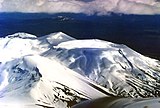
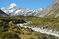
Aoraki / Mount Cook is the highest mountain in New Zealand. Its height, as of 2014, is listed as 3,724 metres. It sits in the Southern Alps, the mountain range that runs the length of the South Island. A popular tourist destination, it is also a favourite challenge for mountain climbers. Aoraki / Mount Cook consists of three summits: from south to north, the Low Peak, the Middle Peak and the High Peak. The summits lie slightly south and east of the main divide of the Southern Alps, with the Tasman Glacier to the east and the Hooker Glacier to the southwest. Mount Cook is ranked 10th in the world by topographic isolation.

<span class="mw-page-title-main">Rangitoto Island</span> Island in New Zealand

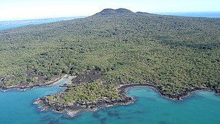
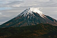
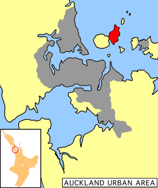
Rangitoto Island is a volcanic island in the Hauraki Gulf near Auckland, New Zealand. The 5.5 km (3.4 mi) wide island is a symmetrical shield volcano cone capped by central scoria cones, reaching a height of 260 m (850 ft). Rangitoto is the youngest and largest of the approximately 50 volcanoes of the Auckland volcanic field, having erupted in two phases about 1450 CE and 1500 CE and covering an area of 2,311 ha. It is separated from the mainland of Auckland's North Shore by the Rangitoto Channel. Since World War II, it has been linked by a causeway to the much older, non-volcanic Motutapu Island.

<span class="mw-page-title-main">Aoraki / Mount Cook National Park</span> National park in New Zealand

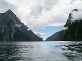
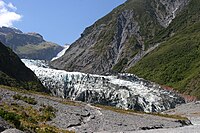
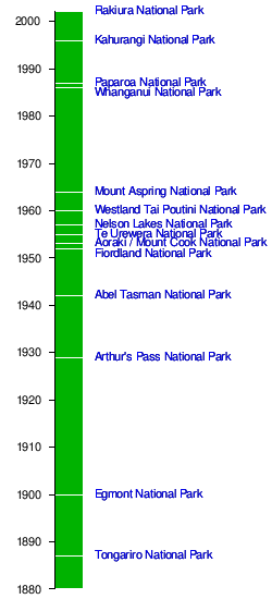
Aoraki / Mount Cook National Park is a national park located in the central-west of the South Island of New Zealand. It was established in October 1953 and takes its name from the highest mountain in New Zealand, Aoraki / Mount Cook. The area of the park is 707 km2 (273 sq mi), and it has a border with Westland Tai Poutini National Park along the Main Divide of the Southern Alps. The national park consists of reserves that were established as early as 1885 to protect the area's significant landscape and vegetation. In 1990, the park was included in the area designated as the Te Wahipounamu World Heritage Site. Glaciers cover 40% of the park, including the county's largest glacier, Haupapa / Tasman Glacier. The park is managed by the Department of Conservation (DOC) alongside Ngāi Tahu, the iwi who are mana whenua in the region.

<span class="mw-page-title-main">Te Wahipounamu</span> UNESCO World Heritage Site

Te Wāhipounamu is a World Heritage Site in the south west corner of the South Island of New Zealand.

<span class="mw-page-title-main">Westland Tai Poutini National Park</span> National park in New Zealand

Westland Tai Poutini National Park is a national park located on the western coast of New Zealand's South Island. Established in 1960 as Westland National Park to commemorate the centenary of the European settlement of Westland District, it covers 1,320 square kilometres of largely mountainous terrain and forest. The park borders the Aoraki / Mount Cook National Park along the Main Divide of the Southern Alps, and includes many of the West Coast's glaciers, most notably including the Fox / Te Moeka o Tuawe and Franz Josef / Kā Roimata o Hine Hukatere glaciers.

<span class="mw-page-title-main">East Coast Bays</span> Area of the North Shore, Auckland, New Zealand

East Coast Bays is a string of small suburbs that form the northernmost part of the North Shore, part of the contiguous Auckland metropolitan area in New Zealand. The suburbs line the north-east coast of the city along the shore of the Hauraki Gulf and Rangitoto Channel. They include, from north to south, Long Bay, Torbay, Waiake Bay, Browns Bay, Rothesay Bay, Murrays Bay, Mairangi Bay, Campbells Bay and Castor Bay. Most of the East Coast Bays are covered under the East Coast Bays subdivision of the Hibiscus and Bays local board area.

<span class="mw-page-title-main">Motutapu Island</span> Island in the Hauraki Gulf of New Zealand

Motutapu Island is a 1,510 ha island in the Hauraki Gulf to the northeast of the city of Auckland, New Zealand. The island is part of the Hauraki Gulf Maritime Park. Its full name, rarely used, is Te Motutapu a Taikehu, "The sacred island of Taikehu", Taikehu having been a tohunga of the Tainui iwi. 'Motutapu', meaning "sacred" or "sanctuary" island, is a term used for various islands in a number of Polynesian cultures. The island can be accessed via regular ferry services departing from Auckland City.

<span class="mw-page-title-main">Hunua Ranges</span> Mountain range and regional park in New Zealand

The Hunua Ranges is a mountain range and regional park to the southeast of Auckland city, in the Auckland and Waikato regions of New Zealand's North Island. The ranges cover some 250 square kilometres (97 sq mi) and rise to 688 metres (2255 ft) at Kohukohunui.

<span class="mw-page-title-main">Protected areas of New Zealand</span>

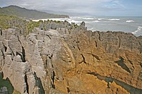
Protected areas of New Zealand are areas that are in some way protected to preserve their environmental, scientific, scenic, historical, cultural or recreational value. There are about 10,000 protected areas, covering about a third of the country. The method and aims of protection vary according to the importance of the resource and whether it is publicly or privately owned.

<span class="mw-page-title-main">Mairangi Bay</span> Suburb in Auckland, New Zealand

Mairangi Bay is a coastal suburb of North Shore, Auckland, located in the northern North Island of New Zealand, on the south-east-facing peninsula forming the northern side of the Waitematā Harbour. Mairangi Bay came under the local governance of the North Shore City Council until subsumed into the Auckland Council in 2010.

<span class="mw-page-title-main">Chatswood, New Zealand</span> Suburb in Auckland, New Zealand

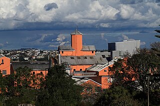
Chatswood is a suburb in the city of Auckland, New Zealand, in the middle-eastern side of North Shore. It contains a primary school and many parks. To the south of Chatswood is Kendall's Bay, a small bay of the Waitematā Harbour. The suburb is under the governance of Auckland Council. The Royal New Zealand Navy's Kauri Point Armament Depot is located in Chatswood. Chelsea Sugar Refinery is located in Chatswood.

<span class="mw-page-title-main">Ngāi Tai ki Tāmaki</span> Māori iwi in New Zealand

Ngāi Tai ki Tāmaki is a Māori tribe that is based in the area around Clevedon, part of the Auckland region. It is one of the twelve members of the Hauraki Collective of tribes.

<span class="mw-page-title-main">Castor Bay</span> Suburb in Auckland, New Zealand

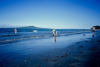
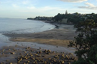
Castor Bay is a bay and suburb of the North Shore, located in Auckland which is in the North Island of New Zealand. Located between Milford and Campbells Bay, it is part of the East Coast Bays. To the east lies the islands of Rangitoto and Motutapu, which are easily visible from land. The suburb is in the North Shore ward, one of the thirteen administrative divisions of Auckland Council.

<span class="mw-page-title-main">Murrays Bay</span> Suburb in Auckland, New Zealand

Murrays Bay is a small suburb in the East Coast Bays region, located in the North Shore of Auckland. The suburb is roughly the same size as Rothesay Bay, the suburb to the immediate north. It is primarily a residential area but does have a community centre, restaurant and café. Murrays Bay is regularly serviced by buses which go to Takapuna and the Auckland city centre.

<span class="mw-page-title-main">Duder Regional Park</span>

Duder Regional Park is a regional park situated on the coast to the east of Auckland, New Zealand, on the Whakakaiwhara Peninsula.

<span class="mw-page-title-main">Long Bay, New Zealand</span> Suburb in Auckland, New Zealand

Long Bay is one of the northernmost suburbs of the North Shore, part of the contiguous Auckland metropolitan area located in New Zealand.

<span class="mw-page-title-main">Kaimaumau wetland</span> Wetland in Northland, New Zealand

The Kaimaumau wetland is a wetland by the Rangaunu Harbour, in Northland, New Zealand. At approximately 1,860 hectares, it is one of the largest remaining wetlands in Northland. It comprises the Otiaita and Waihauhau swamps, Motutangi Swamp Scientific Reserve, and Lake Waikaramu. The wetland is currently threatened by peat mining and by water loss from avocado growing.

<span class="mw-page-title-main">Aotea Conservation Park</span>

Aotea Conservation Park is a 12,300 hectare protected area on Great Barrier Island in New Zealand's Hauraki Gulf. It was established in 2015, and comprises 43 percent of the island.

Northland Conservation Park is a group of protected areas in the Northland Region of New Zealand's North Island.

<span class="mw-page-title-main">Te Matuku Bay</span> Place in Auckland, New Zealand

Te Matuku Bay is a bay on Waiheke Island in New Zealand's Hauraki Gulf. It is one of the largest and least disturbed estuaries on the island. Since 2003, the area has been protected as part of Te Matuku Marine Reserve.

References

  1. "National Parks Act 1980: DOC's role". doc.govt.nz. Department of Conservation. Retrieved 14 August 2010.
  2. "5. Historical and Cultural Heritage: General Policy for National Parks". doc.govt.nz. Department of Conservation. Retrieved 14 August 2010.
  3. "8. Benefit, Use and Enjoyment of the Public: General Policy for National Parks". doc.govt.nz. Department of Conservation. Archived from the original on 15 May 2010. Retrieved 14 August 2010.
  4. "International visitor numbers to larger national parks: Visitor statistics and research". doc.govt.nz. Department of Conservation. Retrieved 14 August 2010.
  5. Retrieved from http://www.legislation.govt.nz/act/public/1980/0066/10.0/096be8ed802f3e20.pdf on 21 August 2010
  6. Neilson, Michael (14 December 2018). "Auckland iwi wins court case over Rangitoto rights stoush". NZ Herald. Retrieved 23 March 2024.
  7. "Ngāi Tai ki Tāmaki Supreme Court Decision". Waatea News. 17 December 2018. Retrieved 24 March 2024.
  8. "DOC delays review of national parks after talks with iwi". RNZ. 4 February 2019. Retrieved 24 March 2024.
  9. Littlewood, Matthew (5 February 2019). "Supreme Court ruling pauses Aoraki/Mt Cook National Park management plan". Stuff . Retrieved 24 March 2024.
  10. "Data Table - Protected Areas - LINZ Data Service (from recorded area in hectares)". Land Information New Zealand . Retrieved 18 October 2017.
  11. "Beehive — New Kauri National Park for Northland". beehive.govt.nz. Retrieved 21 August 2010.
  12. "Minister welcomes progress on Kauri National Park". Wellington, NZ: New Zealand Government. 11 February 2010. Retrieved 12 February 2010.
  13. Forest & Bird case for Great Barrier Island national park
  14. Wade, Amelia (11 August 2020). "Election 2020: National promises two more National Parks, great walks and to be predator-free by 2050". The New Zealand Herald .
  15. Cumming, Geoff (6 March 2010). "Miners press to enter the green zone". The New Zealand Herald . Retrieved 26 March 2010.