Taumoana (Five Finger Peninsula) Marine Reserve

Last updated
Taumoana (Five Finger Peninsula) Marine Reserve
Seal-Islands-New-Zealand-1.JPG
Entrance to Tamatea / Dusky Sound
NZ-SI plain map.png
Disc Plain red.svg
Location Fiordland, New Zealand
Coordinates 45°42′28″S166°31′45″E / 45.7077388°S 166.5292827°E / -45.7077388; 166.5292827
Area464 hectares (1,150 acres)
Established2005
Governing body Department of Conservation

Taumoana (Five Finger Peninsula) Marine Reserve is a marine reserve covering an area of 464 hectares (1,150 acres) in Fiordland on New Zealand's South Island. It was established in 2005 and is administered by the Department of Conservation. It is located next to the Five Fingers Peninsula, at the entrance to Tamatea / Dusky Sound. [1] [2]

Contents

Geography and ecology

The reserve is one of the only protected wave-exposed rocky reef habitats in Fiordland, and is more representative of the outer fiords and coastline than Fiordland's other marine reserves. It may contain significant populations of pāua. [1]

The surrounding hillsides create a layer of freshwater above the seawater. [3]

Ocean swells come into the inlet from the southwest to Parrot and Pigeon Islands and the eastern side of the Five Eyes Peninsula. There are shallow and estuary habitats around the peninsula, Cormorant Cove and Facile Harbour. The marine reserve has lots of direct sunlight due to low-lying hillsides. [1]

History

The Māori name Hāwea is after the ancient iwi of Kāti Hāwea. [4]

Early New Zealand conversationist Richard Henry recognised the number of flightless native birds was decreasing after the introduction of predators. In the late 19th century he spent ten years based alone on Pigeon Island, within the current reserve, transporting kākāpō and kiwi to pest-free areas around Fiordland. [1] [5] His home is protected as a site of national significance. [6] [7]

The reserve was part of a conservation strategy the Fiordland Marine Guardians launched in 2002 and presented to the Ministry for the Environment Marian Hobbs and Minister of Fisheries Pete Hodgson in 2003. [8] It was officially established on 21 April 2005. [9] [2]

The Ministry of Primary Industries, Fiordland Marine Guardians and other agencies are involved in protecting the marine reserve and stopping the spread of invasive seaweed. [3]

The New Zealand Air Force conducted aerial surveillance patrols for illegal commercial fishing in 2021. [10]

Research and commerce

Richard Henry's research findings during his time on Pigeon Island have been widely published. [11] [12]

Ongoing educational and scientific activities are encouraged, but must not disturb or endanger plants, animals or natural features. Scientific research requires a permit from the Department of Conservation. [3]

An area within the marine reserve is designated for commercial rock lobster fishers to store holding pots, including pots to sore live lobsters caught outside the reserve. No other commercial or non-commercial fishing or aquaculture is allowed. [3]

Recreation

The reserve is accessible from Te Anau via the Milford Road. Anchoring boats is banned in many areas to protect the particularly fragile species that can be damaged by anchors or swinging chains. Taking off and landing aircraft is permitted. [3]

Pigeon Island and the home of conversationist Richard Henry are accessible via private or tourist boat. [6]

The protected marine life can be viewed by diving or snorkelling, either independently or with a tourism or charter boat service. To protect the fragile environments, divers must follow the safety and care codes. [3]

There is a ban on fishing, and taking, killing or moving marine life and materials. However, members of Ngāi Tahu may remove pounamu provided they have the right authorisation, only collect by hand, keep disturbance to the site to a minimum, and only carry as much as they can in one trip. They may also collect deceased marine mammals and collect teeth and bones. [3]

See also

Related Research Articles

<span class="mw-page-title-main">Fiordland</span> Geographical region of New Zealand

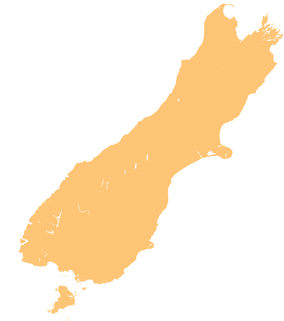
Fiordland is a geographical region of New Zealand in the south-western corner of the South Island, comprising the westernmost third of Southland. Most of Fiordland is dominated by the steep sides of the snow-capped Southern Alps, deep lakes, and its steep, glacier-carved and now ocean-flooded western valleys. The name "Fiordland" comes from a variant spelling of the Scandinavian word for this type of steep valley, "fjord". The area of Fiordland is dominated by, and very roughly coterminous with, Fiordland National Park, New Zealand's largest National Park.

<span class="mw-page-title-main">Fiordland National Park</span> National park on South Island of New Zealand

Fiordland National Park occupies the southwest corner of the South Island of New Zealand. It is by far the largest of the 13 national parks in New Zealand, with an area of 12,607 square kilometres (4,868 sq mi), and a major part of the Te Wahipounamu World Heritage Site. The park is administered by the Department of Conservation.

<span class="mw-page-title-main">Resolution Island (New Zealand)</span> Island in New Zealands Fiordland region

Resolution Island or Tau Moana (Māori) is the largest island in the Fiordland region of southwest New Zealand, covering a total of 208 km2 (80 sq mi). It is the country's seventh largest island, and the second largest uninhabited island. Resolution Island is separated from the mainland of the South Island by Tamatea / Dusky Sound, Te Puaitaha / Breaksea Sound, and Acheron Passage. The island is part of the Fiordland National Park.

<span class="mw-page-title-main">Marine reserves of New Zealand</span>

New Zealand has 44 marine reserves spread around the North, the South Island, and neighbouring islands, and on outlying island groups. They are governed by the Marine Reserves Act 1971 and administered by the Department of Conservation with assistance from the Ministry of Fisheries, New Zealand Customs and the New Zealand Defence Forces.

<span class="mw-page-title-main">Rakituma / Preservation Inlet</span> Fiord in the South Island of New Zealand

Rakituma / Preservation Inlet is the southernmost fiord in Fiordland National Park and lies on the southwest corner of the South Island of New Zealand. With an area of 93 square kilometres (36 sq mi), it is the fourth largest fiord in New Zealand, after Tamatea / Dusky Sound, Doubtful Sound / Patea, and the neighbouring Taiari / Chalky Inlet to the north. Rakituma was briefly the site of an attempted fishing and gold mining settlement at Cromarty during the 19th century, however this was quickly abandoned once the level of gold declined in relation to more promising fields elsewhere.

Hāwea / Bligh Sound is a fiord of the South Island of New Zealand. It is located in Fiordland, 30 kilometres southwest of Milford Sound, and is 15 kilometres in length. The fiord forms a crooked "Z" shape. Wild Natives River flows into the innermost arm, Bounty Haven.

<span class="mw-page-title-main">Charles Sound</span>

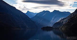
Taiporoporo / Charles Sound is a fiord of the South Island of New Zealand. It is one of the fiords that form the coast of Fiordland.

Hawea Marine Reserve is a marine reserve covering an area of 411 hectares in Hāwea / Bligh Sound, in Fiordland on New Zealand's South Island. It was established in 2005 and is administered by the Department of Conservation.

Taiari / Chalky Inlet is one of the southernmost fiords in Fiordland, in the southwestern corner of New Zealand's South Island and part of Fiordland National Park. As with the neighbouring fiords of Tamatea / Dusky Sound to the north and Rakituma / Preservation Inlet to the south, Taiari / Chalky Inlet is a complex fiord with many channels and islands along its roughly 28 km (17 mi) length. Most notably, this includes the sections Moana-whenua-pōuri / Edwardson Sound and Te Korowhakaunu / Kanáris Sound, which split at Divide Head in the middle of Taiari and each extend for roughly 10 km (6.2 mi) inland in a V-shape.

Long Island-Kokomohua Marine Reserve is a marine reserve, in the Marlborough Region of New Zealand's South Island. It covers an area of 619 hectares at the entrance to the Queen Charlotte Sound in the Marlborough Sounds. It was the first marine reserve established on the South Island.

<span class="mw-page-title-main">Tāwharanui Marine Reserve</span>

Tāwharanui Marine Reserve is a marine reserve covering an area of 394 hectares in the Hauraki Gulf, offshore from the Tāwharanui Peninsula in the Auckland Region of New Zealand's North Island. It was established in 2011 and is administered by the Department of Conservation.

<span class="mw-page-title-main">Te Paepae o Aotea (Volkner Rocks) Marine Reserve</span> Marine reserve in New Zealand territorial waters

Te Paepae o Aotea Marine Reserve is a marine reserve covering an area of 1,267 hectares in the Bay of Plenty of New Zealand's North Island. It includes an area around Te Paepae o Aotea, 55 kilometres (34 mi) north-northwest of Whakatāne and 5 kilometres (3.1 mi) northwest of Whakaari/White Island.

Kahukura Marine Reserve is a marine reserve covering an area of 464 hectares in Charles Sound, in Fiordland on New Zealand's South Island. It was established in 2005 and is administered by the Department of Conservation.

<span class="mw-page-title-main">Kutu Parera (Gaer Arm) Marine Reserve</span> Marine reserve in Fiordland, South Island, New Zealand

Kutu Parera Marine Reserve is a marine reserve covering an area of 433 hectares at Gaer Arm in the Bradshaw Sound of Fiordland on New Zealand's South Island. It was established in 2005 and is administered by the Department of Conservation.

<span class="mw-page-title-main">Te Tapuwae o Hua (Long Sound) Marine Reserve</span>

Te Tapuwae o Hua Marine Reserve is a marine reserve covering an area of 3,672 hectares in Te Awaroa / Long Sound in Fiordland on New Zealand's South Island. It was established in 2005 and is administered by the Department of Conservation.

<span class="mw-page-title-main">Moana Uta (Wet Jacket Arm) Marine Reserve</span> Marine reserve in New Zealand territorial waters

Moana Uta Marine Reserve is a marine reserve covering the entire length of Wet Jacket Arm in Fiordland on New Zealand's South Island, an area of 2,007 hectares. It was established in 2005 and is administered by the Department of Conservation.

<span class="mw-page-title-main">Piopiotahi (Milford Sound) Marine Reserve</span>

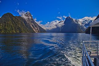
Piopiotahi Marine Reserve is a marine reserve covering an area of 690 hectares in the Milford Sound / Piopiotahi, in Fiordland on New Zealand's South Island. It was established in 1993 and is administered by the Department of Conservation.

<span class="mw-page-title-main">Taipari Roa (Elizabeth Island) Marine Reserve</span> Marine reserve in New Zealand territorial waters

Taipari Roa Marine Reserve is a marine reserve covering an area of 613 hectares around Elizabeth Island, in the inner Doubtful Sound / Patea of Fiordland on New Zealand's South Island. It was established in 2005 and is administered by the Department of Conservation.

Te Hapua Marine Reserve is a marine reserve covering an area of 449 hectares of Te Hāpua / Sutherland Sound, in Fiordland on New Zealand's South Island. It was established in 2005 and is administered by the Department of Conservation.

<span class="mw-page-title-main">Te Awaatu Channel (The Gut) Marine Reserve</span>

Te Awaatu Channel Marine Reserve is a marine reserve covering an area of 93 hectares in Fiordland on New Zealand's South Island. It was established in 1993 and is administered by the Department of Conservation.

References

  1. 1 2 3 4 "Taumoana (Five Finger Peninsula) Marine Reserve". doc.govt.nz. Department of Conservation.
  2. 1 2 Hutching, Gerard. "Marine protected areas". Te Ara - the Encyclopedia of New Zealand . Ministry for Culture and Heritage.
  3. 1 2 3 4 5 6 7 "Fiordland marine reserves". doc.govt.nz. Department of Conservation.
  4. "NZGB notices – October 2019". Land Information New Zealand. 17 October 2019. Retrieved 15 December 2019.
  5. Hill, S (1987). Richard Henry of Resolution Island. Dunedin: John McIndoe Press.
  6. 1 2 "History of Richard Henry's house site". doc.govt.nz. Department of Conservation.
  7. Peat, N (2007). New Zealand’s Fiord Heritage: A Guide to the Historic Sites of Coastal Fiordland. Department of Conservation.
  8. "History". fmg.org.nz. Fiordland Marine Guardians.
  9. "Fiordland (Te Moana o Atawhenua) Marine Management Act 2005". legislation.govt.nz. New Zealand Government.
  10. Baker, Che (7 December 2021). "Illegal fishing targeted in Southland surveillance operation". stuff.co.nz.
  11. Henry, R (1903). The habits of the flightless birds of New Zealand with notes on other New Zealand birds. Wellington: John Mackay.
  12. Begg, A C (1966). Dusky Bay. Whitcombe & Tombs).