
Cavendish is a village and civil parish in the Stour Valley in Suffolk, England.

St Edmundsbury was a local government district and borough in Suffolk, England. It was named after its main town, Bury St Edmunds. The second town in the district was Haverhill. The population of the district was 111,008 at the 2011 Census.

Ingham is a village and civil parish in the West Suffolk district of Suffolk in eastern England, located about six miles north of Bury St Edmunds on the A143 to Thetford in Norfolk. The village boasts a single church, post office and a pub, the Cadogan Arms which was refurbished in 2006.

Whepstead is a village and civil parish in the West Suffolk district of Suffolk in eastern England, located south of Bury St Edmunds. Once the property of Bury Abbey it became a possession of the Drury family at the Dissolution of the Monasteries in the 16th century. Whepstead Church is dedicated to St Petronilla the only such dedication in England.

Bardwell is a village and civil parish in the West Suffolk district of Suffolk, England.

Brockley(not to be confused with Brockley Green, 8 miles southwest in Hundon parish) is a village and civil parish in the West Suffolk district of Suffolk, England. Brockley parish includes the hamlets of Pound Green and Gulling Green. According to the 2001 Census parish population was 281, and increased to 312 at the 2011 Census.
Bradfield Combust with Stanningfield is a civil parish about 6 miles south of Bury St Edmunds, in the West Suffolk district of Suffolk, England.
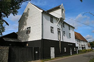
Pakenham is a village and civil parish in the West Suffolk district of Suffolk in eastern England. Its name can be linked to Anglo-Saxon roots, Pacca being the founder of a settlement on the hill surrounding Pakenham church. The village describes itself as the "Village of Two Mills", as it has a water mill which claims to be the only working example in the county. The Pakenham windmill no longer works.
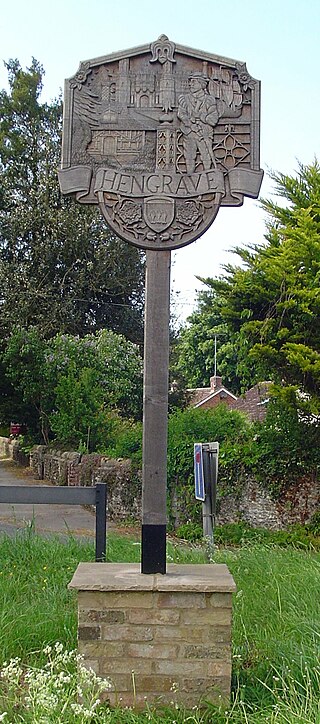
Hengrave is a small village and civil parish in the West Suffolk district, in the county of Suffolk, England. It is to the North the town of Bury St Edmunds along the A1101 road. It is surrounded by the parishes of Flempton, Culford, Fornham St Genevieve, Fornham All Saints and Risby. The River Lark provides the North East boundary of the parish.
Bradfield Combust is a village and former manor and civil parish, now in the parish of Bradfield Combust with Stanningfield, the West Suffolk district, in Suffolk, England, located on the A134 between Windsor Green and Great Whelnetham. In 1961 the parish had a population of 108. In 1988 the parish was merged with Stanningfield to form "Bradfield Combust with Stanningfield".
Bradfield St. George is a village and civil parish in the West Suffolk district of Suffolk, England, about 6 miles (9.7 km) south of Bury St Edmunds.

Gedding is a village and civil parish in the Mid Suffolk district of Suffolk in eastern England. Located around six miles south east of Bury St Edmunds. At the 2011 census its population was 125, rising to 134 at the 2018 ONS mid year estimate.
Westley is a village and civil parish in the West Suffolk district of Suffolk in eastern England. It is located south of Junction 42 of the A14 providing primary access to adjacent market towns Bury St Edmunds (East) and Newmarket (West). The village consists of two central roads: Fornham Lane and Hill Road running north and south through the parish, with adjoining roads accommodating Westley's total population of 183.

Ousden is a village and civil parish in the West Suffolk district of Suffolk in eastern England. It is located around six miles west of Bury St Edmunds and 72 miles north of London, and as of 2011, its population is 266. The village has an Anglican church of St Peter's and a chapel in the cemetery dedicated to St Barnabas.

Nowton is a small village and civil parish in the West Suffolk district of Suffolk in eastern England. Located on the southern edge of Bury St Edmunds, in 2005 its population was estimated to be 140. At the 2011 census 163 people were recorded as living in the village.
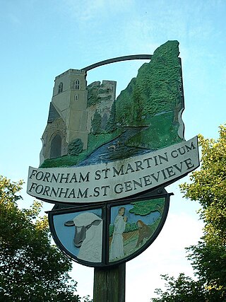
Fornham St Genevieve is a village and civil parish in the West Suffolk district of Suffolk in eastern England. It is one of a trio of contiguous villages by the River Lark. The other villages are Fornham All Saints and Fornham St Martin.
Hawkedon is a village and civil parish in the West Suffolk district of Suffolk in eastern England. Located around 7 miles (11 km) south-south-west of Bury St Edmunds, the parish also contains the hamlet of Thurston End, and in 2005 had a population of 120. The majority of the village is classed as a conservation area.

Stanningfield is a village and former civil parish, now in the parish of Bradfield Combust with Stanningfield, in the West Suffolk district of the county of Suffolk, England. The village lies just off of the A134 road, about 5 miles (8 km) south-east of Bury St Edmunds, 5 miles/8 km north-west of Lavenham, and 10 miles/16 km north of Sudbury. In 1961 the parish had a population of 211.

Bury Road, Lawshall is a linear settlement in the civil parish of Lawshall in the Babergh district in the county of Suffolk, England. The northern part of the settlement is in the civil parish of Bradfield Combust with Stanningfield in West Suffolk. Bury Road is located between Hawstead and Lambs Lane / The Glebe and is two miles off the A134 between Bury St Edmunds and Sudbury.
West Suffolk District is a local government district in Suffolk, England. It was established in 2019 as a merger of the previous Forest Heath District with the Borough of St Edmundsbury. The council is based in Bury St Edmunds, the district's largest town. The district also contains the towns of Brandon, Clare, Haverhill, Mildenhall and Newmarket, along with numerous villages and surrounding rural areas.


