
Honington is a village and civil parish located in Bardwell Ward and Pakenham and Troston Wards of West Suffolk District Council, Suffolk in eastern England It is near to the border with Norfolk. It lies on the River Black Bourn, about 8 miles (13 km) from Bury St Edmunds and 6 miles (10 km) from Thetford, Norfolk. Much of the farmland belongs to the estate of the Duke of Grafton. The village is known for its RAF station, RAF Honington. It is also near two joint RAF/USAF airfields: RAF Lakenheath and RAF Mildenhall. Honington was the birthplace of the poet Robert Bloomfield.
Cranwell is a village in the civil parish of Cranwell, Brauncewell and Byard's Leap, in the North Kesteven district of Lincolnshire, England. It is situated approximately 3 miles (5 km) north-west from Sleaford and 14 miles (23 km) south-east from Lincoln. The principal through road, the B1429 between the A15 to the east and the A17 to the west, joins the village to RAF Cranwell. The appropriate civil parish is called Cranwell, Brauncewell and Byard's Leap with a population of 2,827 at the 2011 census.

Eastchurch is a village and civil parish on the Isle of Sheppey, in the English county of Kent, two miles east of Minster. The village website claims the area has "a history steeped in stories of piracy and smugglers".
Full Sutton is a village and civil parish in the East Riding of Yorkshire, England. It is situated approximately 2 miles east of the village of Stamford Bridge. According to the 2011 UK Census, Full Sutton parish had a population of 1,072, an increase on the 2001 UK Census figure of 977.

Barnham is a village and civil parish in the West Suffolk district of the English county of Suffolk about 3 miles (4.8 km) south of Thetford and 9 miles (14.5 km) north of Bury St Edmunds on the A134. The village of Euston is 1 mile (1.6 km) to the east. According to the Swedish scholar Eilert Ekwall, the name of the village means "Beorn's homestead".

Wattisham is a village and civil parish near to the town of Stowmarket in Suffolk, England. From the 2011 Census the population of the parish was 110, according to the ONS, included in the civil parish of Hitcham.

Exning is a village and civil parish in the West Suffolk district of Suffolk in eastern England.

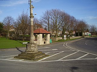
Stanton is a village and civil parish in the West Suffolk district of Suffolk in eastern England, about nine miles north-east of Bury St Edmunds, on the A143 road to Diss. Close to the village lies the former WW II airfield RAF Shepherds Grove, where American forces were based. One of the main landmarks in the village is the fine restored windmill at Upthorpe Farm, to the east of the village. The name " Stanton" means 'a homestead on stony ground'.

Great Waldingfield is a village and civil parish in the Babergh district of Suffolk, England about two miles (3 km) north-east of Sudbury and two miles (3 km) south-west of its sister village, Little Waldingfield. The village is split into two separate parts; the older and smaller part around the St. Lawrence Church, and the newer and larger section along the B1115 road between Sudbury and Lavenham. Most of the houses in the newer section were built after World War II, including much council housing. The parish also includes the hamlets of Upsher Green and part of Washmere Green. The population is estimated to be 1,460, reducing to 1,431 at the 2011 Census.

Cowlinge (/ˈkuː.lɪnʤ/), pronounced "Coolinje", is a village and civil parish in the West Suffolk district of Suffolk in eastern England close to the Cambridgeshire and Essex borders.

East Boldre is a linear village and civil parish situated near Lymington, Hampshire, England. East Boldre is surrounded by the New Forest and forms part of the district of New Forest.
HM Prison Highpoint South is a Category C men's prison, located in the village of Stradishall in Suffolk, England. The prison is operated by His Majesty's Prison Service.

Ellough is a civil parish in the East Suffolk district of the English county of Suffolk, located approximately 3 miles (5 km) south-east of Beccles. The area is sparsely populated with a mid-2005 population estimate of 40. The parish, which has an area of 4.5 square kilometres (1.7 sq mi), borders Worlingham, North Cove, Mutford, Weston, Sotterley, Willingham St Mary and Henstead with Hulver Street. The parish council operates to administer jointly the parishes of Shadingfield, Willingham St Mary, Sotterley and Ellough.

Royal Air Force Stradishall or more simply RAF Stradishall is a former Royal Air Force station located 7 miles (11 km) north east of Haverhill, Suffolk and 9 miles (14 km) south west of Bury St Edmunds, Suffolk, England.
Chedburgh is a village and civil parish in the West Suffolk district of Suffolk in eastern England. Located on the A143 around five miles south-west of Bury St Edmunds, in 2005 its population was 650, reducing to 597 at the 2011 Census.
Flixton is a village and civil parish located in the north of the English county of Suffolk. It is around 2 miles (3.2 km) south-west of Bungay in the East Suffolk district and is one of the villages around Bungay which make up the area known as The Saints. The A143 road runs just to the north of the parish border linking Bungay with Harleston and Diss.
HM Prison Highpoint North is a Category C men's prison, located in the village of Stradishall in Suffolk, England. The prison is operated by His Majesty's Prison Service.

Snailwell is a small village and civil parish in East Cambridgeshire, England around 4 kilometres (2.5 mi) north of Newmarket.

St James South Elmham is a village and civil parish in the north of the English county of Suffolk. It is 4.5 miles (7.2 km) north-west of the market town of Halesworth and 5.5 miles (8.9 km) south-west of Bungay in the East Suffolk district. It is one of the parishes around Bungay known as the Saints.
Lauri Love is a British activist who was previously charged by the United States for his alleged activities with the hacker collective Anonymous. Love's case has been cited as precedent in the Julian Assange extradition proceedings.

