
The Erie Canal is a historic canal in upstate New York that runs east–west between the Hudson River and Lake Erie. Completed in 1825, the canal was the first navigable waterway connecting the Atlantic Ocean to the Great Lakes, vastly reducing the costs of transporting people and goods across the Appalachians. In effect, the canal accelerated the settlement of the Great Lakes region, the westward expansion of the United States, and the economic ascendancy of New York State. It has been called "The Nation's First Superhighway."

Hornell is a city in Steuben County, New York, United States. The population was 8,259 at the 2020 census. The city is named after the Hornell family, early settlers.

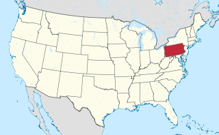
Delmont is a borough in Westmoreland County, Pennsylvania. The population was 2,592 at the 2020 census.

Ennis is a city in eastern Ellis County, Texas, United States. The population is 20,159 according to the 2020 census, with an estimated population of 21,210 in 2021. Ennis is home to the annual National Polka Festival.

Olean is a city in Cattaraugus County, New York, United States. Olean is the largest city in Cattaraugus County and serves as its financial, business, transportation and entertainment center. It is one of the principal cities of the Southern Tier region of Western New York.
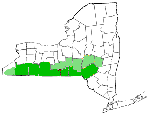
The Southern Tier is a geographic subregion of the broader Upstate region of New York State, geographically situated along or very near the state border with Pennsylvania. Definitions of the region vary widely, but generally encompass counties surrounding the Binghamton and Elmira-Corning metropolitan areas. This region is adjacent to the Northern Tier of Pennsylvania, and both these regions together are known as the Twin Tiers.
The Philadelphia Main Line, known simply as the Main Line, is an informally delineated historical and social region of suburban Philadelphia, Pennsylvania. Lying along the former Pennsylvania Railroad's once prestigious Main Line, it runs northwest from Center City Philadelphia parallel to Lancaster Avenue, also known as U.S. Route 30.

The Northeast Corridor Line is a commuter rail service operated by NJ Transit between the Trenton Transit Center and New York Penn Station on Amtrak's Northeast Corridor in the United States. The service is the successor to Pennsylvania Railroad commuter trains between Trenton and New York, and is NJ Transit's busiest commuter rail service. After arrival at New York Penn Station, some trains load passengers and return to New Jersey, while others continue east to Sunnyside Yard for storage. Most servicing is done at the Morrisville Yard, at the west end of the line.

Huntingdon and Broad Top Mountain Railroad (H&BTM) is a former short line railroad company operating passenger and freight service on standard gauge track in south central Pennsylvania.
The United New Jersey Railroad and Canal Company (UNJ&CC) was a United States-based railroad company established in 1872. It was formed by the consolidation of three existing companies: the Camden and Amboy Railroad, Delaware and Raritan Canal Company, and New Jersey Rail Road and Transportation Company. The Camden and Amboy and New Jersey Rail Road were among the earliest North American railroads. The Pennsylvania Railroad leased the United New Jersey Railroad and Canal Company in 1872.

Interstate 86 (I-86) is an Interstate Highway that extends for 223.39 miles (359.51 km) through northwestern Pennsylvania and the Southern Tier region of New York, in the United States. The highway has two segments: the longer of the two begins at an interchange with I-90 east of Erie, Pennsylvania, and ends just beyond the Chemung-Tioga county line at the Pennsylvania border, while the second extends from I-81 east of Binghamton to New York State Route 79 (NY 79) in Windsor. When projects to upgrade the existing NY 17 to Interstate Highway standards are completed, I-86 will extend from I-90 near Erie to the New York State Thruway (I-87) in Woodbury. The portion in Erie County, Pennsylvania, is known as the Hopkins-Bowser Highway and is signed as such at each end. In New York, the current and future alignment of I-86 is known as the Southern Tier Expressway west of I-81 in Binghamton and the Quickway east of I-81.

The Lehigh and Hudson River Railway (L&HR) was the smallest of the six railroads that were merged into Conrail in 1976. It was a bridge line running northeast–southwest across northwestern New Jersey, connecting the line to the Poughkeepsie Bridge at Maybrook, New York with Easton, Pennsylvania, where it interchanged with various other companies.

The Delaware and Hudson Canal was the first venture of the Delaware and Hudson Canal Company, which would later build the Delaware and Hudson Railway. Between 1828 and 1899, the canal's barges carried anthracite coal from the mines of northeastern Pennsylvania to the Hudson River and thence to market in New York City.
Magnolia is an unincorporated community northeast of Paw Paw in Morgan County in the U.S. state of West Virginia on the Potomac River. Magnolia is located along the Baltimore and Ohio Railroad mainline and east of where the Western Maryland Railway crosses the Potomac, bypassing a series of bends in the river. As a depot and water station on the B&O, Magnolia has been known by a number of names including Magnolia Dale, Magnolia Vale, and sometimes as Water Station Number 12 on the railroad.

Tacony is a historic neighborhood in Northeast Philadelphia, United States, approximately 8 miles (13 km) from downtown Philadelphia. It is bounded by the east side of Frankford Avenue on the northwest, the south side of Cottman Avenue on the northeast, the north side of Robbins Street on the southwest, and the Delaware River and Interstate 95 on the southeast.

Sloatsburg station is a commuter rail stop on the Metro-North Railroad's Port Jervis Line, located in the village of Sloatsburg, New York at the intersection of Municipal Plaza and Mills Street.

Millville is a defunct settlement in Jo Daviess County, Illinois, United States, located within the boundaries of Apple River Canyon State Park. Founded in 1835 and platted in 1846, the community was washed away completely by a flood in 1892. No visible remnants of its structures remain today. The site of Millville was added to the U.S. National Register of Historic Places as the Millville Town Site in 2003.
Marion Station, also known as Marion, is an unincorporated community in Somerset County, Maryland, United States. It is located at the northern intersection of Maryland routes 413 and 667. After the arrival of the Pennsylvania Railroad arm known as the "Eastern Shore Railroad" toward Crisfield in 1866, Marion was locally hailed as the "strawberry capital of the world". After the trains stopped coming it went into decline, with some sources even hailing it as a ghost town.
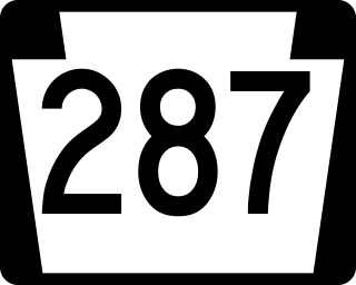
Pennsylvania Route 287 is a 63.9-mile-long (102.8 km) state highway in the Tioga Valley of Pennsylvania, United States. Route 287 runs from an intersection with U.S. Route 220 in the community of Larrys Creek in Piatt Township, Lycoming County, north to an intersection with PA 49 just south of the New York state line in Lawrenceville, Tioga County. The route follows Larrys Creek through several isolated communities, including Salladasburg and English Center, before working its way towards Hoytville, where it meets PA 414. The route ends up in Wellsboro, where it meets US 6, and reaches Tioga.

A stage station or relay station, also known as a staging post, a posting station, or a stage stop, is a facility along a main road or trade route where a traveller can rest and/or replace exhausted working animals for fresh ones, since long journeys are much faster with less delays when using well fed and rested mounts. Stage is the space between the places known as stations or stops — also known in British English as posts or relays.

