Warrington Township, York County, Pennsylvania

Last updated

Warrington Township,
York County,
Pennsylvania
Gifford Pinchot State Park Sailboats.jpg
Gifford Pinchot State Park is in Warrington Township
York County Pennsylvania incorporated and unincorporated areas Warrington township highlighted.svg
Location in York County and the state of Pennsylvania.
Country United States
State Pennsylvania
County York
Settled1735
Incorporated1744
Government
  TypeBoard of Supervisors
Area
[1]
  Total36.10 sq mi (93.50 km2)
  Land35.30 sq mi (91.42 km2)
  Water0.81 sq mi (2.08 km2)
Population
 (2020) [2]
  Total4,547 Increase2.svg
  Estimate 
(2021) [2]
4,561
  Density130.15/sq mi (50.25/km2)
Time zone UTC-5 (Eastern (EST))
  Summer (DST) UTC-4 (EDT)
Area code 717
FIPS code 42-133-81056
Historical population
CensusPop.Note
1930 1,349
1940 1,52012.7%
1950 1,80618.8%
1960 2,04113.0%
1970 2,49422.2%
1980 3,58643.8%
1990 4,27519.2%
2000 4,4353.7%
2010 4,5322.2%
2020 4,5470.3%
2021 (est.)4,561 [2] 0.3%
U.S. Decennial Census [3]

Warrington Township is a township in York County, Pennsylvania, United States. The population was 4,547 at the 2020 census. [2] The township is named after Warrington, England, like many townships having English names in York County. Others dispute the origin, believing it may be named after Waringstown, County Down, now in Northern Ireland. [4]

Contents

History

The Warrington Meetinghouse was added to the National Register of Historic Places in 1975. [5]

Geography

According to the United States Census Bureau, the township has a total area of 36.0 square miles (93 km2), of which 35.4 square miles (92 km2) is land and 0.6 square miles (1.6 km2), or 1.75%, is water. The township completely surrounds the borough of Wellsville.

Demographics

As of the census [6] of 2000, there were 4,435 people, 1,702 households, and 1,329 families living in the township. The population density was 125.4 inhabitants per square mile (48.4/km2). There were 1,766 housing units at an average density of 49.9 per square mile (19.3/km2). The racial makeup of the township was 98.47% White, 0.23% African American, 0.11% Native American, 0.43% Asian, 0.07% from other races, and 0.70% from two or more races. Hispanic or Latino of any race were 1.04% of the population.

There were 1,702 households, out of which 32.6% had children under the age of 18 living with them, 67.9% were married couples living together, 6.3% had a female householder with no husband present, and 21.9% were non-families. 16.2% of all households were made up of individuals, and 5.1% had someone living alone who was 65 years of age or older. The average household size was 2.59 and the average family size was 2.89.

In the township the population was spread out, with 23.8% under the age of 18, 6.6% from 18 to 24, 30.9% from 25 to 44, 29.3% from 45 to 64, and 9.4% who were 65 years of age or older. The median age was 40 years. For every 100 females, there were 99.5 males. For every 100 females age 18 and over, there were 101.4 males.

Building in Rossville Rossville York Co PA.JPG
Building in Rossville

The median income for a household in the township was $47,425, and the median income for a family was $51,941. Males had a median income of $37,940 versus $26,203 for females. The per capita income for the township was $21,368. About 1.5% of families and 2.6% of the population were below the poverty line, including 0.5% of those under age 18 and 5.2% of those age 65 or over.

Related Research Articles

<span class="mw-page-title-main">Curtin Township, Centre County, Pennsylvania</span> Township in Pennsylvania, United States

Curtin Township is a township in Centre County, Pennsylvania, United States. It is part of the State College, Pennsylvania Metropolitan Statistical Area. The population was 500 at the 2020 census.

<span class="mw-page-title-main">Ferguson Township, Centre County, Pennsylvania</span> Home rule municipality in Pennsylvania, United States

Ferguson Township is a township with home rule status in Centre County, Pennsylvania, United States. It is part of the State College, Pennsylvania Metropolitan Statistical Area. The population was 19,009 at the 2020 census. Most of the agricultural research for Pennsylvania State University, based in adjacent State College, Pennsylvania, is taking place at the Russell E. Larson Research Center located in the western part of Ferguson Township. The headquarters of AccuWeather are also located within the township.

<span class="mw-page-title-main">Mount Pleasant Township, Columbia County, Pennsylvania</span> Township in Pennsylvania, United States

Mount Pleasant Township is a township in Columbia County, Pennsylvania. It is part of Northeastern Pennsylvania. As of the 2020 census, the township population was 1,506.

<span class="mw-page-title-main">Orange Township, Pennsylvania</span> Township in Pennsylvania, United States

Orange Township is a township in Columbia County, Pennsylvania. It is part of Northeastern Pennsylvania. The population was 1,163 at the 2020 census.

<span class="mw-page-title-main">Dickinson Township, Cumberland County, Pennsylvania</span> Township in Pennsylvania, United States

Dickinson Township is a township in Cumberland County, Pennsylvania, United States. The population was 5,223 at the 2010 census, up from 4,702 at the 2000 census.

<span class="mw-page-title-main">South Newton Township, Pennsylvania</span> Township in Pennsylvania, United States

South Newton Township is a township in Cumberland County, Pennsylvania, United States. The population was 1,383 at the 2010 census.

<span class="mw-page-title-main">Upper Paxton Township, Pennsylvania</span> Township in Pennsylvania, United States

Upper Paxton Township is a township in Dauphin County, Pennsylvania, United States. The population was 4,014 at the 2020 census.

<span class="mw-page-title-main">Greene Township, Erie County, Pennsylvania</span> Township in Pennsylvania, United States

Greene Township is a township in Erie County, Pennsylvania, United States. The population was 4,487 at the 2020, down from 4,706 at the 2010 census.

<span class="mw-page-title-main">Waterford Township, Pennsylvania</span> Township in Pennsylvania, United States

Waterford Township is a township in Erie County, Pennsylvania, United States. The population was 3,910 at the 2020 census, down from 3,920 at the 2010 census.

<span class="mw-page-title-main">Bullskin Township, Pennsylvania</span> Township in Pennsylvania, United States

Bullskin Township is a township in Fayette County, Pennsylvania, United States. The population was 6,741 at the 2020 census, a decline from the figure of 6,966 tabulated in 2010. It is served by the Connellsville Area School District.

<span class="mw-page-title-main">Perry Township, Fayette County, Pennsylvania</span> Township in Pennsylvania, United States

Perry Township is a township in Fayette County, Pennsylvania, United States. The population was 2,339 at the 2020 census, a decline from the figure of 2,552 tabulated in 2010. The Frazier School District serves the township.

<span class="mw-page-title-main">Upper Tyrone Township, Pennsylvania</span> Township in Pennsylvania, United States

Upper Tyrone Township is a township that is located in Fayette County, Pennsylvania, United States. The population was 1,768 at the time of the 2020 census. It is served by the Southmoreland School District.

<span class="mw-page-title-main">Knox Township, Jefferson County, Pennsylvania</span> Township in Pennsylvania, United States

Knox Township is a township in Jefferson County, Pennsylvania, in the United States. As of the 2020 census, the township population was 1,008. It was named for John C. Knox, then President Judge of the judicial district.

<span class="mw-page-title-main">Upper Leacock Township, Pennsylvania</span> Township in Pennsylvania, United States

Upper Leacock Township is a township in east central Lancaster County, Pennsylvania, United States. The population was 8,949 at the 2020 census.

<span class="mw-page-title-main">East Brunswick Township, Pennsylvania</span> Township in Pennsylvania, United States

East Brunswick Township is a township in Schuylkill County, Pennsylvania. Brunswick Township was formed in 1801 as one of the original townships of Schuylkill County, being named for Brunswick (Braunschweig), Germany. In 1834, Brunswick Township was divided into East and West Brunswick Townships. Today both townships are served by the Blue Mountain School District.

<span class="mw-page-title-main">Gregg Township, Union County, Pennsylvania</span> Township in Pennsylvania, United States

Gregg Township is a township in Union County, Pennsylvania, United States. The population was 4,339 at the 2020 census, of which 3,679 were federal inmates.

<span class="mw-page-title-main">Canal Township, Pennsylvania</span> Township in Pennsylvania, United States

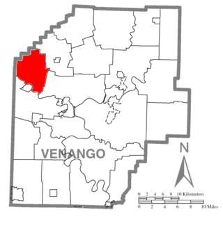
Canal Township is a township in Venango County, Pennsylvania, United States. The population was 927 at the 2020 census, a decrease from 1,203 in 2010, which was, in turn, an increase over the figure of 1,008 tabulated as of the 2000 census.

<span class="mw-page-title-main">Conewago Township, York County, Pennsylvania</span> Township in Pennsylvania, United States

Conewago Township is a township in York County, Pennsylvania, United States. The township encompasses the land between the Conewago Creek and the Little Conewago Creek, west of their conjunction. The township was formed in 1818 from the northeastern portion of Dover Township and the southeastern portion of Newberry Township and consists of approximately 11,000 acres. The population was 8,527 at the 2020 census.

<span class="mw-page-title-main">Monaghan Township, Pennsylvania</span> Township in Pennsylvania, United States

Monaghan Township is a township in York County, Pennsylvania, United States. The population was 2,674 at the 2020 census.

<span class="mw-page-title-main">Bishop Township, Effingham County, Illinois</span> Township in Illinois, United States

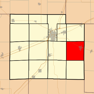
Bishop Township is one of fifteen townships in Effingham County, Illinois, USA. As of the 2020 census, its population was 1,702 and it contained 629 housing units.

References

  1. "2016 U.S. Gazetteer Files". United States Census Bureau. Retrieved August 14, 2017.
  2. 1 2 3 4 "City and Town Population Totals: 2020-2021". Census.gov. US Census Bureau. Retrieved July 8, 2022.
  3. "Census of Population and Housing". Census.gov. Retrieved June 4, 2016.
  4. From Rostrevor to Raphoe An Overview of Ulster Place-Names in Pennsylvania 1700-1820
  5. "National Register Information System". National Register of Historic Places . National Park Service. July 9, 2010.
  6. "U.S. Census website". United States Census Bureau . Retrieved January 31, 2008.

40°05′00″N76°56′59″W / 40.08333°N 76.94972°W / 40.08333; -76.94972