Pennville, Pennsylvania

Last updated

Pennville
CDP
York County Pennsylvania incorporated and unincorporated areas Pennville highlighted.svg
Location in York County and the U.S. state of Pennsylvania.
Coordinates: 39°47′12″N76°59′31″W / 39.78667°N 76.99194°W / 39.78667; -76.99194
Country United States
State Pennsylvania
County York
Township Penn
Area
[1]
  Total0.95 sq mi (2.47 km2)
  Land0.95 sq mi (2.47 km2)
  Water0.00 sq mi (0.00 km2)
Elevation
[2]
584 ft (178 m)
Population
 (2020) [3]
  Total2,430
  Density2,544.50/sq mi (982.54/km2)
Time zone UTC-5 (Eastern (EST))
  Summer (DST) UTC-4 (EDT)
ZIP code
17331 [4]
Area code 717
FIPS code 42-59296
GNIS feature ID2389662 [2]

Pennville is a census-designated place (CDP) in York County, Pennsylvania, United States. The population was 1,947 at the 2010 census. [5]

Contents

Geography

Pennville is located in Penn Township, adjacent to the borough of Hanover.

According to the United States Census Bureau, the CDP has a total area of 0.7 square miles (1.8 km2), all land.

Demographics

Historical population
CensusPop.Note
2020 2,430
U.S. Decennial Census [6]

At the 2000 census there were 1,964 people, 659 households, and 461 families living in the CDP. The population density was 2,718.1 inhabitants per square mile (1,049.5/km2). There were 682 housing units at an average density of 943.9 per square mile (364.4/km2). The racial makeup of the CDP was 98.01% White, 0.46% African American, 0.10% Native American, 0.41% Asian, 0.51% from other races, and 0.51% from two or more races. Hispanic or Latino of any race were 0.92%. [7]

Of the 659 households 31.7% had children under the age of 18 living with them, 54.6% were married couples living together, 10.6% had a female householder with no husband present, and 29.9% were non-families. 22.8% of households were one person and 8.3% were one person aged 65 or older. The average household size was 2.51 and the average family size was 2.94.

The age distribution was 21.1% under the age of 18, 6.5% from 18 to 24, 27.0% from 25 to 44, 17.4% from 45 to 64, and 28.0% 65 or older. The median age was 42 years. For every 100 females, there were 82.9 males. For every 100 females age 18 and over, there were 77.2 males.

The median household income was $38,934 and the median family income was $47,841. Males had a median income of $36,231 versus $21,520 for females. The per capita income for the CDP was $18,252. None of the families and 3.3% of the population were living below the poverty line, including no under eighteens and 13.7% of those over 64.

Related Research Articles

<span class="mw-page-title-main">Galena, Indiana</span> Census-designated place in Indiana, United States

Galena is a census-designated place (CDP) in Floyd County, Indiana, United States. The population was 1,818 at the 2010 census. The CDP includes the town of Galena as well as the nearby town of Floyds Knobs and their immediate surroundings.

<span class="mw-page-title-main">Pine Point, Minnesota</span> Census-designated place in Minnesota, United States

Pine Point is a census-designated place (CDP) in Becker County, Minnesota, United States. The population was 338 at the 2010 census.

<span class="mw-page-title-main">Hillside Lake, New York</span> Census-designated place in New York, United States

Hillside Lake is a hamlet and census-designated place (CDP) in Dutchess County, New York, United States. The population was 1,084 at the 2010 census. It is part of the Poughkeepsie–Newburgh–Middletown, NY Metropolitan Statistical Area as well as the larger New York–Newark–Bridgeport, NY-NJ-CT-PA Combined Statistical Area.

<span class="mw-page-title-main">Forestville, Ohio</span> Census-designated place in Ohio, United States

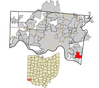
Forestville is a census-designated place (CDP) in Hamilton County, Ohio, United States. The population was 10,615 at the 2020 census.

<span class="mw-page-title-main">West Hills, Pennsylvania</span> Census-designated place in Pennsylvania, United States

West Hills is a census-designated place (CDP) in Armstrong County, Pennsylvania, United States. The population was 1,228 at the 2020 census.

Whitfield is a census-designated place (CDP) in Berks County, Pennsylvania, United States. The population was 4,733 at the 2010 census.

<span class="mw-page-title-main">Nixon, Pennsylvania</span> Census-designated place in Pennsylvania, United States

Nixon is a census-designated place (CDP) in Penn Township, Butler County, Pennsylvania, United States. The population was 1,373 at the 2010 census.

Guilford is a census-designated place (CDP) in Franklin County, Pennsylvania, United States. The population was 2,923 at the 2020 census.

East Waterford is a census-designated place (CDP) in Tuscarora and Lack townships in Juniata County, Pennsylvania, United States. The population was 196 at the 2010 census.

<span class="mw-page-title-main">New Castle Northwest, Pennsylvania</span> Census-designated place in Pennsylvania, United States

New Castle Northwest is an unincorporated area and census-designated place (CDP) in Lawrence County, Pennsylvania, United States. The population was 1,413 at the 2010 census.

<span class="mw-page-title-main">Brodheadsville, Pennsylvania</span> Census-designated place in Pennsylvania, United States

Brodheadsville is a census-designated place (CDP) in Monroe County, Pennsylvania, United States. The population was 1,700 at the 2020 census. The community is served by Pleasant Valley School District.

<span class="mw-page-title-main">Mountainhome, Pennsylvania</span> Census-designated place in Pennsylvania, United States

Mountainhome is a census-designated place (CDP) in Barrett Township, Monroe County, Pennsylvania, United States. The population was 1,182 at the 2010 census.

<span class="mw-page-title-main">Donaldson, Pennsylvania</span> CDP in Pennsylvania, United States

Donaldson is a census-designated place (CDP) in Frailey Township, Schuylkill County, Pennsylvania, United States. The population was 325 at the 2000 census.

Fountain Springs is a census-designated place in Butler Township, Schuylkill County, Pennsylvania, United States. The population was 100 at the 2000 census.

<span class="mw-page-title-main">Baidland, Pennsylvania</span> Census-designated place in Pennsylvania, United States

Baidland is a census-designated place (CDP) in Washington County, Pennsylvania, United States. The population was 1,563 at the 2010 census.

<span class="mw-page-title-main">Emigsville, Pennsylvania</span> CDP in Pennsylvania, United States

Emigsville is a census-designated place (CDP) in York County, Pennsylvania, United States. The population was 3,563 at the 2020 census.

<span class="mw-page-title-main">Grantley, Pennsylvania</span> CDP in Pennsylvania, United States

Grantley is a census-designated place (CDP) in York County, Pennsylvania, United States. The population was 3,628 at the 2010 census.

<span class="mw-page-title-main">Parkville, Pennsylvania</span> CDP in Pennsylvania, United States

Parkville is a census-designated place (CDP) in York County, Pennsylvania, United States. The population was 6,706 at the 2010 census.

<span class="mw-page-title-main">Valley Green, Pennsylvania</span> CDP in Pennsylvania, United States

Valley Green is a census-designated place (CDP) in York County, Pennsylvania, United States. The population was 3,429 at the 2010 census.

<span class="mw-page-title-main">Valley View, York County, Pennsylvania</span> CDP in Pennsylvania, United States

Valley View is a census-designated place (CDP) in York County, Pennsylvania, United States. The population was 2,817 at the 2010 census.

References

  1. "ArcGIS REST Services Directory". United States Census Bureau. Retrieved October 16, 2022.
  2. 1 2 U.S. Geological Survey Geographic Names Information System: Pennville, Pennsylvania
  3. "Census Population API". United States Census Bureau. Retrieved October 16, 2022.
  4. "Pennville PA ZIP Code". zipdatamaps.com. 2023. Retrieved May 13, 2023.
  5. "Race, Hispanic or Latino, Age, and Housing Occupancy: 2010 Census Redistricting Data (Public Law 94-171) Summary File (QT-PL), Pennville CDP, Pennsylvania". United States Census Bureau . Retrieved October 17, 2011.
  6. "Census of Population and Housing". Census.gov. Retrieved June 4, 2016.
  7. "U.S. Census website". United States Census Bureau . Retrieved January 31, 2008.