Manheim Township, York County, Pennsylvania

Last updated
Manheim Township,
York County,
Pennsylvania
Codorus State Park.jpg
York County Pennsylvania incorporated and unincorporated areas Manheim township highlighted.svg
Location of Manheim Township in York County, Pennsylvania (left) and of York County in Pennsylvania (right)
Country United States
State Pennsylvania
County York
Settled1732
Incorporated1747
Government
  TypeBoard of Supervisors
Area
[1]
  Total22.50 sq mi (58.29 km2)
  Land21.54 sq mi (55.80 km2)
  Water0.96 sq mi (2.49 km2)
Population
 (2020) [2]
  Total3,457 Increase2.svg
  Estimate 
(2021) [2]
3,469
  Density160.51/sq mi (61.97/km2)
Time zone UTC-5 (Eastern (EST))
  Summer (DST) UTC-4 (EDT)
Area code 717
FIPS code 42-133-46904
Website Official website
Historical population
CensusPop.Note
1850 1,806
1860 1,091−39.6%
1870 1,1596.2%
1880 1,29311.6%
1890 1,258−2.7%
1900 1,226−2.5%
1910 1,38212.7%
1920 1,336−3.3%
1930 1,189−11.0%
1940 1,2343.8%
1950 1,2592.0%
1990 2,692
2000 3,11915.9%
2010 3,3808.4%
2020 3,4572.3%
2021 (est.)3,469 [2] 0.3%
U.S. Decennial Census [3]

Manheim Township is a township in York County, Pennsylvania, United States. As of the 2020 census, the township population was 3,457. [2]

Contents

Geography

According to the U.S. Census Bureau, the township has a total area of 22.5 square miles (58 km2), of which 21.5 square miles (56 km2) is land and 0.9 square miles (2.3 km2), or 4.10%, is water.

Demographics

At the 2000 census, there were 3,119 people, 1,084 households, and 924 families living in the township. The population density was 144.8 inhabitants per square mile (55.9/km2). There were 1,119 housing units at an average density of 52.0 per square mile (20.1/km2). The racial makeup of the township was 98.62% White, 0.26% Native American, 0.29% Asian, 0.06% from other races, and 0.77% from two or more races. Hispanic or Latino of any race were 0.26%. [4]

Of the 1,084 households 39.6% had children under the age of 18 living with them, 76.8% were married couples living together, 5.3% had a female householder with no husband present, and 14.7% were non-families. 11.5% of households were one person and 4.3% were one person aged 65 or older. The average household size was 2.88 and the average family size was 3.11.

The age distribution was 27.7% under the age of 18, 5.5% from 18 to 24, 30.0% from 25 to 44, 27.5% from 45 to 64, and 9.3% 65 or older. The median age was 38 years. For every 100 females there were 104.0 males. For every 100 females age 18 and over, there were 100.9 males.

The median household income was $57,407 and the median family income was $60,912. Males had a median income of $39,899 versus $24,408 for females. The per capita income for the township was $22,652. About 3.3% of families and 4.2% of the population were below the poverty line, including 1.7% of those under age 18 and 6.6% of those age 65 or over.

Fire protection

Manheim Township is protected by three volunteer fire departments: the Lineboro Volunteer Fire Department out of Lineboro, Maryland protects the southern half of the township. Pleasant Hill Volunteer Fire Dept protects the northwestern quarter of the township, while the Jefferson Volunteer Fire Co. protects the northeastern quarter of the township.

Emergency Medical Services

The Lineboro Volunteer Fire Department provides ALS or Advanced Life Support ambulance services to Manheim Township, and Pleasant Hill Volunteer Fire Co provides BLS or Basic Life Support ambulance services. Medic 2-90 from UPMC Hanover Hospital provides ALS care in 52 box areas or in the event that Station 7's ambulance is unavailable. Service 47, out of Jefferson Volunteer Fire Company, also provides BLS assistance services on Class 1 calls in parts of the township. STAT Medevac provides air ambulance services in the event of severe illness or injury.

Related Research Articles

<span class="mw-page-title-main">Stockton, New York</span> Town in New York, United States

Stockton is a town in Chautauqua County, New York, United States. The population was 2,036 at the 2020 census. The town is named after Richard Stockton, who signed the Declaration of Independence.

<span class="mw-page-title-main">Columbia Township, Bradford County, Pennsylvania</span> Township in Pennsylvania, United States

Columbia Township is a township in Bradford County, Pennsylvania, United States. It is part of Northeastern Pennsylvania. The population was 1,196 at the 2010 census. Children residing in the township are assigned to attend the Troy Area School District.

<span class="mw-page-title-main">Standing Stone Township, Pennsylvania</span> Township in Pennsylvania, United States

Standing Stone Township is a township in Bradford County, Pennsylvania, United States. The population was 642 at the 2010 census.

<span class="mw-page-title-main">Towanda Township, Pennsylvania</span> Township in Pennsylvania, United States

Towanda Township is a township in Bradford County, Pennsylvania, United States. It is part of Northeastern Pennsylvania. The population was 1,149 at the 2010 census.

<span class="mw-page-title-main">Nicholson Township, Fayette County, Pennsylvania</span> Township in Pennsylvania, United States

Nicholson Township is a township in Fayette County, Pennsylvania, United States. The population was 1,730 at the 2020 census, a decline from the figure of 1,805 tabulated in 2010. The Albert Gallatin Area School District serves the township. New Geneva, Martin, Gallatin, Old Frame, Bowood, Woodside, and Grays Landing are communities in the township.

<span class="mw-page-title-main">Jackson Township, Huntingdon County, Pennsylvania</span> Township in Pennsylvania, United States

Jackson Township is an American township that is located in Huntingdon County, Pennsylvania. The population was 859 at the time of the 2020 census.

<span class="mw-page-title-main">Manheim Township, Lancaster County, Pennsylvania</span> Township in Pennsylvania, United States

Manheim Township is a township in Lancaster County, Pennsylvania, United States. It was established in 1729. The township's southernmost border meets the city limits of Lancaster and includes the communities of Neffsville, Dillerville, and Landis Valley. Its population, as of the 2020 census, was 43,977 making it the second largest municipality in the county after Lancaster City.

<span class="mw-page-title-main">Schaefferstown, Pennsylvania</span> Census-designated place in Pennsylvania, United States

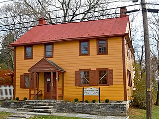
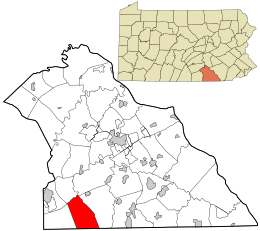
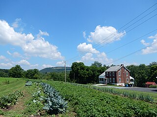
Schaefferstown is an unincorporated community and census-designated place (CDP) in Heidelberg Township, Lebanon County, Pennsylvania, United States. The population was 941 at the 2010 census.

<span class="mw-page-title-main">Foster Township, Luzerne County, Pennsylvania</span> Township in Pennsylvania, United States

Foster Township is a township in Luzerne County, Pennsylvania. The population was 3,413 at the 2020 census.

<span class="mw-page-title-main">Newport Township, Pennsylvania</span> First Class Township in Pennsylvania, United States

Newport Township is a township in Luzerne County, Pennsylvania, United States. As of 2020, the population was 4,444. Newport is located on the outskirts of Nanticoke City.

<span class="mw-page-title-main">Lower Mahanoy Township, Pennsylvania</span> Township in Pennsylvania, United States

Lower Mahanoy Township is a township in Northumberland County, Pennsylvania, United States. The population at the 2010 Census was 1,709, an increase over the figure of 1,586 tabulated in 2000.

<span class="mw-page-title-main">North Manheim Township, Pennsylvania</span> Township in Pennsylvania, United States

North Manheim Township is a township that is located in Schuylkill County, Pennsylvania, United States. The population was 4,043 at the time of the 2020 census.

<span class="mw-page-title-main">South Manheim Township, Pennsylvania</span> Township in Pennsylvania, United States

South Manheim Township is a township that is located in Schuylkill County, Pennsylvania, United States. The population was 2,751 at the time of the 2020 census.

<span class="mw-page-title-main">Union Township, Snyder County, Pennsylvania</span> Township in Pennsylvania, United States

Union Township is a township in Snyder County, Pennsylvania, United States. The population was 1,493 at the 2020 census.

<span class="mw-page-title-main">Sullivan Township, Pennsylvania</span> Township in Pennsylvania, United States

Sullivan Township is a township in Tioga County, Pennsylvania, United States. The population was 1,470 at the 2020 census.

<span class="mw-page-title-main">Pine Grove Township, Warren County, Pennsylvania</span> Township in Pennsylvania, United States

Pine Grove Township is a township in Warren County, Pennsylvania, United States. As of the 2020 census, the township population was 2,603, down from 2,965 at the 2010 census.

<span class="mw-page-title-main">Dover Township, Pennsylvania</span> Township in Pennsylvania, United States

Dover Township is a township in York County, Pennsylvania, United States. The population was 22,366 at the 2020 census.

<span class="mw-page-title-main">Jefferson, York County, Pennsylvania</span> Borough in Pennsylvania, United States

Jefferson is a borough in York County, Pennsylvania, United States. The population was 655 at the time of the 2020 census. It is part of the York–Hanover metropolitan area.

<span class="mw-page-title-main">West Manheim Township, Pennsylvania</span> Township in Pennsylvania, United States

West Manheim Township is a township in York County, Pennsylvania, United States, just north of the Mason-Dixon Line. The population was 9,052 at the 2020 census. The community is a suburb of Baltimore and part of its Designated Market Area.

<span class="mw-page-title-main">Wrightsville, Pennsylvania</span> Borough in Pennsylvania, United States

Wrightsville is a borough in York County, Pennsylvania, United States. The population was 2,257 at the time of the 2020 census. It is part of the York–Hanover metropolitan area.

References

  1. "2016 U.S. Gazetteer Files". United States Census Bureau. Retrieved Aug 14, 2017.
  2. 1 2 3 4 Bureau, US Census. "City and Town Population Totals: 2020-2021". Census.gov. US Census Bureau. Retrieved 8 July 2022.
  3. "Census of Population and Housing". Census.gov. Retrieved June 4, 2016.
  4. "U.S. Census website". United States Census Bureau . Retrieved 2008-01-31.

39°44′30″N76°52′59″W / 39.74167°N 76.88306°W / 39.74167; -76.88306