
Saluda County is a county in the U.S. state of South Carolina. As of the 2020 census, the population was 18,862. Its county seat is Saluda. The county was formed from northern and eastern portions of Edgefield County.

Richland County is located in the U.S. state of South Carolina. As of the 2020 census, its population was 416,147, making it the second-most populous county in South Carolina, behind only Greenville County. The county seat and largest community is Columbia, the state capital. The county was established on March 12, 1785. Richland County is part of the Columbia, SC Metropolitan Statistical Area. In 2020, the center of population of South Carolina was located in Richland County, in the city of Columbia. The county is also the location of the geographic center of South Carolina, southeast of Columbia.

Orangeburg County is a county located in the U.S. state of South Carolina. As of the 2020 census, the population was 84,223. Its county seat is Orangeburg. The county was created in 1769.

Newberry County is a county located in the U.S. state of South Carolina. As of the 2020 census, its population was 37,719. Its county seat is Newberry. The name is of unknown origin, although one theory suggests that it was named by Quaker settlers in honor of their home of Newberry, a suburb of London in the United Kingdom.
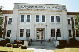
Lexington County is a county located in the U.S. state of South Carolina. As of the 2020 census, the population was 293,991. Its county seat and largest community is Lexington. The county was chartered in 1785 and was named in commemoration of Lexington, Massachusetts, the site of the Battle of Lexington in the American Revolutionary War. Lexington County is the sixth-most populous county in South Carolina by population and is part of the Columbia, SC Metropolitan Statistical Area. It is located in the Midlands region of South Carolina.

Kershaw County is a county located in the U.S. state of South Carolina. As of the 2020 census, its population was 65,403. The county seat and largest community is Camden. The county was created in 1791 from parts of Claremont, Lancaster, Fairfield, and Richland counties. It is named for Col. Joseph Kershaw (1727–1791), an early settler and American Revolutionary War patriot.

Fairfield County is a county located in the U.S. state of South Carolina. As of the 2020 census, its population was 20,948. Its county seat is Winnsboro.
Scouting in South Carolina has a long history, from the 1910s to the present day, serving thousands of youth in programs that suit the environment in which they live.

Winnsboro Mills is an unincorporated community and census-designated place (CDP) in Fairfield County, South Carolina, United States. The population was 1,898 at the 2010 census, down from 2,263 at the 2000 census. It is part of the Columbia, South Carolina Metropolitan Statistical Area.
Seven Oaks is a census-designated place (CDP) in Lexington County, South Carolina, United States, 8 miles (13 km) northwest of downtown Columbia, the state capital. The population of the CDP was 15,144 at the 2010 census. It is part of the Columbia Metropolitan Statistical Area.

The Midlands region of South Carolina is the middle area of the state. The region's main center is Columbia, the state's capital. The Midlands is so named because it is halfway point between the Upstate and the Lowcountry. The main area code is 803.

The Monroe metropolitan area, officially the Monroe metropolitan statistical area, is a metropolitan statistical area in Northern Louisiana that covers three parishes—Ouachita, Union, and Morehouse. According to the 2020 census, the MSA had a population of 207,104.

Area codes 803 and 839 are telephone area codes in the North American Numbering Plan (NANP) for the central part of the U.S. State of South Carolina. The numbering plan area (NPA) is anchored by the city of Columbia, the state capital. It also includes most of the South Carolina portions of the Charlotte, North Carolina and Augusta, Georgia metropolitan areas. 839, an all-service overlay, was approved by the South Carolina Public Service Commission in 2019.

There are currently seven United States congressional districts in South Carolina. There have been as few as four and as many as nine congressional districts in South Carolina. The 9th district and the 8th district were lost after the 1840 census. The 5th district and the 6th district were also briefly lost after the Civil War, but both had been regained by the 1880 census. Because of the state population growth in the 2010 census, South Carolina regained its 7th district, which had remained unused since the Civil War.
The Kalamazoo–Portage Metropolitan Area comprises a region surrounding Kalamazoo. 2015 estimates placed it as the 151st largest among similarly designated areas in the United States. 2015 estimates place the combined statistical area 85th among similarly designated areas.
The Peoria Metropolitan Statistical Area, as defined by the United States Census Bureau, is an area consisting of six counties in Central Illinois, anchored by the city of Peoria. As of the 2020 census, the area had a population of 402,391. The City of Peoria, according to the 2020 US Census Bureau, has 113,150 people.

The South Carolina Circuit Court is the state court of general jurisdiction of the U.S. state of South Carolina. It consists of a civil division and a criminal division.

The 1976 United States presidential election in South Carolina took place on November 2, 1976. All 50 states and the District of Columbia were part of the 1976 United States presidential election. South Carolina voters chose eight electors to the Electoral College, who voted for president and vice president. Despite fluctuating polls, Carter would carry South Carolina by a margin of 13.04 points over Ford.

