
Dane County is a county in the U.S. state of Wisconsin. As of the 2020 census, the population was 561,504, making it the second-most populous county in Wisconsin after Milwaukee County. The county seat is Madison, which is also the state capital.

Medina is a town in Dane County, Wisconsin, United States. The population was 1,235 at the 2000 census. The unincorporated community of Deansville is located in the town.

Rockdale is a village in Dane County, Wisconsin, United States. The population was 207 at the 2020 census, making it the smallest incorporated municipality in Dane County. The village is split in half by the Koshkonong Creek. It is part of the Madison Metropolitan Statistical Area.

Rutland is a town in Dane County, Wisconsin, United States. The population was 1,977 by the US Census Bureau 2020 census The population was 1,887 at the 2000 census. However, for 2021, the Wisconsin Dept. of Administration declared the population of the Town to be 2,032. The unincorporated communities of Rutland and Stone are located in the town.

Shorewood Hills is a village in Dane County, Wisconsin, United States. It was established in 1927. The population was 2,169 at the 2020 census. Entirely surrounded by the city of Madison and Lake Mendota, it is part of the Madison Metropolitan Statistical Area.

Springfield is a town in Dane County, Wisconsin, United States. The population was 2,929 at the time of the 2020 census. The unincorporated communities of Ashton, Ashton Corners, Kingsley Corners, Martinsville, and Springfield Corners are located in Springfield.

Waunakee is a village in Dane County, Wisconsin, United States. The population was estimated at 16,165 in 2023. It is part of the Madison Metropolitan Statistical Area. Waunakee bills itself as "The Only Waunakee in the World".
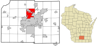
The Town of Westport is located in Dane County, Wisconsin, United States and a suburb of Madison. The population was 4,183 at the 2020 census. The town was named after Westport, County Mayo in Ireland because many of the early settlers were from there. The village of Waunakee was carved out of the town in 1893, leaving the remainder of the town on both sides. Other portions have been annexed by the cities of Madison and Middleton. A portion of the Town of Madison on the northern shore of Lake Mendota was transferred to the Town of Westport.

Belleville is a village in Dane and Green counties in the U.S. state of Wisconsin. The population was 2,491 at the 2020 census. Of this, 1,909 were in Dane County, and 582 were in Green County.

Cambridge is a village in Dane (mostly) and Jefferson counties in the U.S. state of Wisconsin. The population was 1,638 at the 2020 census. Of this, 1,539 were in Dane County, and 99 were in Jefferson County.

Black Earth is a village in Dane County, Wisconsin, United States. The population was 1,338 at the 2010 census. The village is located within the Town of Black Earth. It is part of the Madison Metropolitan Statistical Area.

Blue Mounds is a village in Dane County, Wisconsin, United States. As of the 2020 census, the village had a population of 950. The village is adjacent to the Town of Blue Mounds, and is part of the Madison Metropolitan Statistical Area.

Blue Mounds is a town in Dane County, Wisconsin, United States. The population was 899 at the 2020 census. The Village of Blue Mounds is located within the town.

Cross Plains is a town in Dane County, Wisconsin, United States. The population was 1,419 at the 2000 census. The Village of Cross Plains is located partially within the town. The unincorporated community of Pine Bluff is located in the town.

Cross Plains is a village in Dane County, Wisconsin, United States. The population was 4,104 at the 2020 census. The village is located partially within the Town of Cross Plains. It is part of the Madison Metropolitan Statistical Area.

Dane is a town in Dane County, Wisconsin, United States. The population was 968 at the 2000 census. The unincorporated community of Lutheran Hill is located partially in the town.

Deerfield is a city in Dane County, Wisconsin. The population was 2,319 at the time of the 2010 census. The city is located within the Town of Deerfield. It is part of the Madison Metropolitan Statistical Area. Towns and villages near Deerfield include Marshall, Medina, London, Cambridge, and Cottage Grove, Wisconsin.

Mazomanie is a town in Dane County, Wisconsin. The population was 1,185 at the time of the 2000 census. The Village of Mazomanie is located within the town.

Windsor is a village and former town in Dane County, Wisconsin. The population was 8,754 at the time of the 2020 census. The communities of Lake Windsor, Morrisonville, and Token Creek are located within the village. Windsor voted to incorporate as a village on November 3, 2015; prior to its incorporation, it was a town, and a portion of the town was a census-designated place. Windsor is a part of the Census Bureau's Madison metropolitan statistical area.

Brooklyn is a village in Dane and Green counties in Wisconsin, United States. The population was 1,524 at the 2020 census, with 1,026 residents in Dane County and 498 in Green County.


