Maple Bluff, Wisconsin

Last updated

Maple Bluff, Wisconsin
Maple Bluff Village Center - panoramio.jpg
Maple Bluff Village Center
Dane County Wisconsin Incorporated and Unincorporated areas Maple Bluff Highlighted.svg
Location of Maple Bluff in Dane County, Wisconsin.
Coordinates: 43°6′39″N89°22′6″W / 43.11083°N 89.36833°W / 43.11083; -89.36833
Country Flag of the United States.svg  United States
State Flag of Wisconsin.svg  Wisconsin
County Dane
Area
[1]
  Total0.70 sq mi (1.82 km2)
  Land0.70 sq mi (1.82 km2)
  Water0.00 sq mi (0.00 km2)
Elevation
[2]
876 ft (267 m)
Population
 (2010) [3]
  Total1,313
  Estimate 
(2019) [4]
1,311
  Density1,870.19/sq mi (721.78/km2)
Time zone UTC-6 (Central (CST))
  Summer (DST) UTC-5 (CDT)
Area code 608
FIPS code 55-48750 [5]
GNIS feature ID1568959 [2]
Website www.villageofmaplebluff.com

Maple Bluff is a village in Dane County, Wisconsin, United States. The population was 1,313 at the 2010 census. A suburb of Madison, it is part of the Madison Metropolitan Statistical Area.

Contents

Maple Bluff is the site of the Wisconsin Governor's Mansion, the residence of the governor of Wisconsin and their family. The Robert M. La Follette House is also in Maple Bluff.

Municipal services

Maple Bluff is served by the Maple Bluff Police Department. The Maple Bluff Fire Department provides fire protection service and non-transporting emergency medical service to the village. Ambulance transport services are contracted to a private ambulance provider.

Geography

Maple Bluff is located at 43°6′39″N89°22′6″W / 43.11083°N 89.36833°W / 43.11083; -89.36833 (43.110945, -89.368263). [6]

According to the United States Census Bureau, the village has a total area of 0.69 square miles (1.79 km2), all of it land. [7]

Demographics

Historical population
CensusPop.Note
1940 862
1950 1,36157.9%
1960 1,56515.0%
1970 1,97426.1%
1980 1,351−31.6%
1990 1,3520.1%
2000 1,3580.4%
2010 1,313−3.3%
2020 (est.)1,307 [8] −0.5%
U.S. Decennial Census [9]

2010 census

As of the census [3] of 2010, there were 1,313 people, 547 households, and 401 families living in the village. The population density was 1,902.9 inhabitants per square mile (734.7/km2). There were 592 housing units at an average density of 858.0 per square mile (331.3/km2). The racial makeup of the village was 95.9% White, 1.1% African American, 0.3% Native American, 0.8% Asian, 0.5% from other races, and 1.4% from two or more races. Hispanic or Latino of any race were 1.4% of the population.

There were 681 households, of which 29.1% had children under the age of 18 living with them, 67.5% were married couples living together, 3.5% had a female householder with no husband present, 2.4% had a male householder with no wife present, and 26.7% were non-families. 20.5% of all households were made up of individuals, and 6.5% had someone living alone who was 65 years of age or older. The average household size was 2.40 and the average family size was 2.79.

The median age in the village was 48 years. 22.3% of residents were under the age of 18; 3.2% were between the ages of 18 and 24; 19.3% were from 25 to 44; 38.8% were from 45 to 64; and 16.4% were 65 years of age or older. The gender makeup of the village was 49.4% male and 50.6% female.

2000 census

As of the census [5] of 2000, there were 1,358 people, 541 households, and 407 families living in the village. The population density was 1,944.1 people per square mile (749.0/km2). There were 557 housing units, at an average density of 797.4 per square mile (307.2/km2). The racial makeup of the village was 97.13% White, 1.33% African American, 0.22% Native American, 0.37% Asian, 0.29% from other races, and 0.66% from two or more races. Hispanic or Latino of any race were 0.66% of the population.

There were 541 households, out of which 31.4% had children under the age of 18 living with them, 69.7% were married couples living together, 4.3% had a female householder with no husband present, and 24.6% were non-families. 19.0% of all households were made up of individuals, and 9.1% had someone living alone who was 65 years of age or older. The average household size was 2.51 and the average family size was 2.88.

In the village, the population was spread out, with 24.0% under the age of 18, 4.3% from 18 to 24, 22.2% from 25 to 44, 31.6% from 45 to 64, and 17.9% who were 65 years of age or older. The median age was 45 years. For every 100 females, there were 93.2 males. For every 100 females age 18 and over, there were 91.5 males.

The median income for a household in the village was $111,400, and the median income for a family was $129,961. Males had a median income of $83,074 versus $50,000 for females. The per capita income for the village was $66,380. About 1.7% of families and 2.5% of the population were below the poverty line, including 1.2% of those under age 18 and 2.1% of those age 65 or over.

Notable people

Related Research Articles

<span class="mw-page-title-main">Malden, Illinois</span> Village in Illinois, United States

Malden is a village in Bureau County, Illinois, United States. The population was 318 at the 2010 census. It is part of the Ottawa, IL Micropolitan Statistical Area.

<span class="mw-page-title-main">Maple Lake, Minnesota</span> City in Minnesota, United States

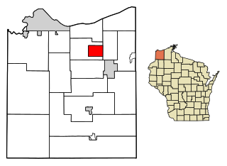
Maple Lake is a city in Wright County, Minnesota, United States. The population was 2,159 at the 2020 census. Minnesota State Highway 55 serves as a main route in the city.

<span class="mw-page-title-main">Yorkville, Oneida County, New York</span> Village in New York, United States

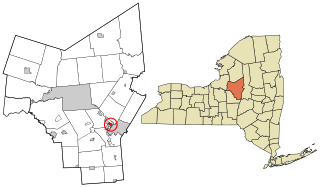
Yorkville is a village in Oneida County, New York, United States. The population was 2,689 at the 2010 census.

<span class="mw-page-title-main">Shorewood Hills, Wisconsin</span> Village in Wisconsin, United States

Shorewood Hills is a village in Dane County, Wisconsin, United States. It was established in 1927. The population was 2,169 at the 2020 census. Entirely surrounded by the city of Madison and Lake Mendota, it is part of the Madison Metropolitan Statistical Area.

<span class="mw-page-title-main">Poplar, Wisconsin</span> Village in Wisconsin, United States

Poplar is a village in Douglas County, Wisconsin, United States. The population was 603 at the 2010 census.

<span class="mw-page-title-main">Wyalusing, Wisconsin</span> Town in Wisconsin, United States

Wyalusing is a town in Grant County, Wisconsin, United States. The population was 370 at the 2000 census. The unincorporated communities of Brodtville and Wyalusing are located in the town. Pioneer Robert Glenn, Sr. is credited with naming the village "Wyalusing" after Wyalusing, Pennsylvania, because of a perceived resemblance.

<span class="mw-page-title-main">Reedsville, Wisconsin</span> Village in Wisconsin, United States

Reedsville is a village in Manitowoc County, Wisconsin, United States. The population was 1,195 at the 2020 census.

<span class="mw-page-title-main">Brokaw, Wisconsin</span> Village in Wisconsin, United States

Brokaw is a former village in Marathon County, Wisconsin, United States. It is part of the Wausau, Wisconsin Metropolitan Statistical Area. The population was 251 at the 2010 census. Brokaw merged with the village of Maine, Wisconsin on October 1, 2018.

<span class="mw-page-title-main">Maple Valley, Wisconsin</span> Town in Wisconsin, United States

Maple Valley is a town in Oconto County, Wisconsin, United States. The population was 670 at the 2000 census.

<span class="mw-page-title-main">Exeland, Wisconsin</span> Village in Wisconsin, United States

Exeland is a village in Sawyer County, Wisconsin, United States. The population was 229 at the 2020 census.

<span class="mw-page-title-main">Vernon, Wisconsin</span> Village in Wisconsin, United States

Vernon is a village in Waukesha County, Wisconsin, United States. The population was 7,474 at the 2020 census.

<span class="mw-page-title-main">Montfort, Wisconsin</span> Village in Wisconsin, United States

Montfort is a village in Grant and Iowa Counties in the U.S. state of Wisconsin. The population was 718 at the 2010 census. Of this, 622 were in Grant County, and 96 were in Iowa County.

<span class="mw-page-title-main">Randolph, Wisconsin</span> Village in Wisconsin, United States

Randolph is a village in Columbia and Dodge Counties in the U.S. state of Wisconsin. The population was 1,811 at the 2010 census. Of this, 1,339 were in Dodge County, and 472 were in Columbia County. The village is located at the southeast corner of the Town of Randolph in Columbia County, although only a tiny portion of the village lies within the town. Most of the village lies within the Town of Westford in Dodge County. Small portions also lie within the Town of Fox Lake to the north and the Town of Courtland in Columbia County.

<span class="mw-page-title-main">Wyocena, Wisconsin</span> Village in Wisconsin, United States

Wyocena is a village in Columbia County, Wisconsin, United States. The population was 768 at the 2010 census. The village is located within the Town of Wyocena. It is part of the Madison Metropolitan Statistical Area.

<span class="mw-page-title-main">Black Earth, Wisconsin</span> Village in Wisconsin, United States

Black Earth is a village in Dane County, Wisconsin, United States. The population was 1,338 at the 2010 census. The village is located within the Town of Black Earth. It is part of the Madison Metropolitan Statistical Area.

<span class="mw-page-title-main">Cross Plains (town), Wisconsin</span> Town in Dane County, Wisconsin

Cross Plains is a town in Dane County, Wisconsin, United States. The population was 1,419 at the 2000 census. The Village of Cross Plains is located partially within the town. The unincorporated community of Pine Bluff is located in the town.

<span class="mw-page-title-main">Madison (town), Wisconsin</span> Town in Wisconsin, United States

The Town of Madison was located in Dane County, Wisconsin, United States. The town ceased to exist on October 31, 2022. Its final population was 6,236 at the 2020 United States census. The majority of the town's territory was situated along the Madison Beltline Highway, comprising several neighborhoods situated between the south side of the city of Madison, and the north side of the city of Fitchburg. The town also had territory on the north side of Madison near the border with Maple Bluff, as well as a few lots on the west side of Madison near Whitney Way. The Dane County Expo Center and Alliant Energy Center was situated within the Town of Madison. Despite its status as an unincorporated community, the Town of Madison provided a variety of services to its residents which typically would only be found in incorporated cities and villages, including trash and recycling services, police, fire and emergency medical services; sewer and water utilities; and three public parks.

<span class="mw-page-title-main">Lena, Wisconsin</span> Village in Wisconsin, United States

Lena is a village in Oconto County, Wisconsin, United States. The population was 564 at the 2010 census. It is part of the Green Bay Metropolitan Statistical Area. The village is located within the Town of Lena.

<span class="mw-page-title-main">Ironton, Wisconsin</span> Village in Wisconsin, United States

Ironton is a village in Sauk County, Wisconsin, United States, along the Little Baraboo River. The population was 253 at the 2010 census. The village is located within the Town of Ironton.

<span class="mw-page-title-main">Brooklyn (village), Wisconsin</span> Place in Wisconsin, United States

Brooklyn is a village in Dane and Green counties in Wisconsin, United States. The population was 1,524 at the 2020 census, with 1,026 residents in Dane County and 498 in Green County.

References

  1. "2019 U.S. Gazetteer Files". United States Census Bureau. Retrieved August 7, 2020.
  2. 1 2 "US Board on Geographic Names". United States Geological Survey. October 25, 2007. Retrieved January 31, 2008.
  3. 1 2 "U.S. Census website". United States Census Bureau . Retrieved November 18, 2012.
  4. "Population and Housing Unit Estimates". United States Census Bureau. May 24, 2020. Retrieved May 27, 2020.
  5. 1 2 "U.S. Census website". United States Census Bureau . Retrieved January 31, 2008.
  6. "US Gazetteer files: 2010, 2000, and 1990". United States Census Bureau. February 12, 2011. Retrieved April 23, 2011.
  7. "US Gazetteer files 2010". United States Census Bureau. Archived from the original on January 25, 2012. Retrieved November 18, 2012.
  8. "City and Town Population Totals: 2010-2020" . Retrieved June 22, 2021.
  9. "Census of Population and Housing". Census.gov. Retrieved June 4, 2015.

Further reading