Dunn, Dane County, Wisconsin

Last updated

Town of Dunn, Wisconsin
Dane County Wisconsin incorporated and unincorporated areas Dunn highlighted.svg
Location in Dane County and the state of Wisconsin.
Coordinates: 42°58′47″N89°18′24″W / 42.97972°N 89.30667°W / 42.97972; -89.30667
Country Flag of the United States.svg  United States
State Flag of Wisconsin.svg  Wisconsin
County Dane
Area
  Total34.4 sq mi (89.2 km2)
  Land28.6 sq mi (74.2 km2)
  Water5.8 sq mi (15.0 km2)
Elevation
[1]
886 ft (270 m)
Population
 (2000)
  Total4,880
  Density184.0/sq mi (71.0/km2)
Time zone UTC-6 (Central (CST))
  Summer (DST) UTC-5 (CDT)
Area code 608
FIPS code 55-21125 [2]
GNIS feature ID1583105 [1]

Dunn is a town in Dane County, Wisconsin, United States. The population was 4,880 at the 2020 census.

Contents

Geography

According to the United States Census Bureau, the town has a total area of 34.4 square miles (89.1 km2), of which, 28.6 square miles (74.2 km2) of it is land and 5.8 square miles (15.0 km2) of it (16.79%) is water.

Demographics

At the 2000 census there were 5,270 people, 2,079 households, and 1,563 families living in the town. The population density was 184.0 people per square mile (71.0/km2). There were 2,259 housing units at an average density of 78.9 per square mile (30.4/km2). The racial makeup of the town was 97.80% White, 0.21% African American, 0.25% Native American, 0.49% Asian, 0.66% from other races, and 0.59% from two or more races. Hispanic or Latino of any race were 1.75%. [2]

Of the 2,079 households 31.4% had children under the age of 18 living with them, 65.6% were married couples living together, 5.6% had a female householder with no husband present, and 24.8% were non-families. 17.6% of households were one person and 4.5% were one person aged 65 or older. The average household size was 2.53 and the average family size was 2.87.

The age distribution was 23.2% under the age of 18, 5.2% from 18 to 24, 29.8% from 25 to 44, 32.8% from 45 to 64, and 9.0% 65 or older. The median age was 41 years. For every 100 females, there were 105.5 males. For every 100 females age 18 and over, there were 103.3 males.

The median household income was $66,250 and the median family income was $71,228. Males had a median income of $41,497 versus $32,071 for females. The per capita income for the town was $30,881. None of the families and 1.7% of the population were living below the poverty line, including no under eighteens and none of those over 64.

Related Research Articles

<span class="mw-page-title-main">Royal Center, Indiana</span> Town in Indiana, United States

Royal Center is a town in Boone Township, Cass County, Indiana, United States. The population was 861 at the 2010 census.

<span class="mw-page-title-main">Chesterville, Maine</span> Town in Maine, United States

Chesterville is a town in Franklin County, Maine, United States. The population was 1,328 at the 2020 census.

<span class="mw-page-title-main">Penobscot, Maine</span> Town in the state of Maine, United States

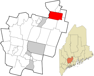
Penobscot is a town in Hancock County, Maine, United States. The Bagaduce River flows through the town. The population was 1,136 at the 2020 census.

<span class="mw-page-title-main">Benton, Maine</span> Town in the state of Maine, United States

Benton is a town in Kennebec County, Maine, United States. It was formed in 1842, as a subdivision of the town of Clinton. The population was 2,715 at the 2020 census. The town was named for Missouri Senator Thomas Hart Benton.

Newburgh is a town in Penobscot County, Maine, United States. The population was 1,595 at the time of the 2020 census.

Canaan is a town in Somerset County, Maine, United States. The population was 2,193 at the 2020 census.

<span class="mw-page-title-main">Smithfield, Maine</span> Town in the state of Maine, United States

Smithfield is a town in Somerset County, Maine, United States. The population was 925 at the 2020 census. The town was incorporated on February 29, 1840, making it the only town in Maine incorporated on Leap Day. The town was named after the Rev. Henry Smith, an early settler.

<span class="mw-page-title-main">St. John, Missouri</span> City in Missouri, United States

St. John or Saint John is a city in St. Louis County, Missouri, United States, with its commercial district centered along St. Charles Rock Road. It is a few miles southeast of Lambert-St. Louis International Airport.

<span class="mw-page-title-main">Killdeer, North Dakota</span> City in North Dakota, United States

Killdeer is a city in Dunn County, North Dakota, United States. The population was 939 at the 2020 census.

<span class="mw-page-title-main">Downing, Wisconsin</span> Village in Wisconsin, United States

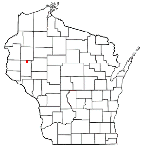
Downing is a village in Dunn County, Wisconsin, United States. Bordering St. Croix County to the west, the village is otherwise surrounded by the Town of Tiffany. The population was 234 at the 2020 census.

<span class="mw-page-title-main">Grant, Dunn County, Wisconsin</span> Town in Wisconsin, United States

Grant is a town in Dunn County, Wisconsin, United States. The population was 426 at the 2000 census.

<span class="mw-page-title-main">Hay River, Wisconsin</span> Town in Wisconsin, United States

Hay River is a town in Dunn County, Wisconsin, United States, along the Hay River. The population was 546 at the 2000 census. The unincorporated community of Baxter is located in the town.

<span class="mw-page-title-main">Lucas, Wisconsin</span> Town in Wisconsin, United States

Lucas is a town in Dunn County, Wisconsin, United States. The population was 658 at the 2000 census. The unincorporated community of Hatchville is located partially in the town.

<span class="mw-page-title-main">Otter Creek, Dunn County, Wisconsin</span> Town in Wisconsin, United States

Otter Creek is a town in Dunn County, Wisconsin, United States. The population was 474 at the 2000 census.

<span class="mw-page-title-main">Peru, Wisconsin</span> Town in Wisconsin, United States

The Town of Peru is a Town located in Dunn County, Wisconsin, United States. The population was 247 at the 2000 census. The unincorporated communities of Meridean and Red Cedar and the ghost towns of Old Tyrone and Old Meridean are located in the town.

Spring Brook is a town in Dunn County, Wisconsin, United States. The population was 1,320 at the 2000 census. The unincorporated community of Falls City is located in the town.

<span class="mw-page-title-main">Weston, Dunn County, Wisconsin</span> Town in Wisconsin, United States

Weston is a town in Dunn County, Wisconsin, United States. The population was 630 at the 2000 census. The unincorporated communities of Comfort and Weston are located in the town. The unincorporated community of Hatchville is also located partially in the town.

<span class="mw-page-title-main">Wilson, Dunn County, Wisconsin</span> Town in Wisconsin, United States

Wilson is a town in Dunn County, Wisconsin, United States. The population was 500 at the 2000 census.

Elk Mound is a town in Dunn County, Wisconsin, United States. The population was 1,121 according to the 2000 census. The town is named after the Village of Elk Mound, located in the eastern part of the town.

<span class="mw-page-title-main">Menomonie (town), Wisconsin</span> Town in Wisconsin, United States

Menomonie is a town in Dunn County, Wisconsin, United States. The population was 3,174 at the 2000 census. The unincorporated community of Irvington lies within the town, as does most of the City of Menomonie.

References

  1. 1 2 "US Board on Geographic Names". United States Geological Survey. October 25, 2007. Retrieved January 31, 2008.
  2. 1 2 "U.S. Census website". United States Census Bureau . Retrieved January 31, 2008.