Rockdale, Wisconsin

Last updated

Rockdale, Wisconsin
Rockdale, WI sign.jpg
Dane County Wisconsin Incorporated and Unincorporated areas Rockdale Highlighted.svg
Location of Rockdale in Dane County, Wisconsin.
Coordinates: 42°58′21″N89°2′2″W / 42.97250°N 89.03389°W / 42.97250; -89.03389
Country Flag of the United States.svg  United States
State Flag of Wisconsin.svg  Wisconsin
County Dane
Area
[1]
  Total0.30 sq mi (0.77 km2)
  Land0.28 sq mi (0.73 km2)
  Water0.02 sq mi (0.04 km2)
Elevation
[2]
833 ft (254 m)
Population
 (2020) [3]
  Total207
  Density768.68/sq mi (296.90/km2)
Time zone UTC-6 (Central (CST))
  Summer (DST) UTC-5 (CDT)
Area code 608
FIPS code 55-68725 [4]
GNIS feature ID1572479 [2]
Website http://www.villageofrockdale.com/

Rockdale is a village in Dane County, Wisconsin, United States. The population was 207 at the 2020 census, making it the smallest incorporated municipality in Dane County. The village is split in half by the Koshkonong Creek. It is part of the Madison Metropolitan Statistical Area.

Contents

Geography

Rockdale is located in the Town of Christiana at 42°58′21″N89°2′2″W / 42.97250°N 89.03389°W / 42.97250; -89.03389 (42.972476, -89.033886). [5]

According to the United States Census Bureau, the village has a total area of 0.24 square miles (0.62 km2), of which, 0.23 square miles (0.60 km2) of it is land and 0.01 square miles (0.03 km2) is water. [6]

Demographics

Historical population
CensusPop.Note
1920 139
1930 135−2.9%
1940 1360.7%
1950 16118.4%
1960 19118.6%
1970 172−9.9%
1980 20016.3%
1990 23517.5%
2000 214−8.9%
2010 2140.0%
2020 207−3.3%
U.S. Decennial Census [7]

2010 census

As of the census [3] of 2010, there were 214 people, 89 households, and 60 families living in the village. The population density was 930.4 inhabitants per square mile (359.2/km2). There were 94 housing units at an average density of 408.7 per square mile (157.8/km2). The racial makeup of the village was 99.1% White, 0.5% Asian, and 0.5% from two or more races. Hispanic or Latino of any race were 1.9% of the population.

There were 89 households, of which 29.2% had children under the age of 18 living with them, 55.1% were married couples living together, 9.0% had a female householder with no husband present, 3.4% had a male householder with no wife present, and 32.6% were non-families. 23.6% of all households were made up of individuals, and 3.3% had someone living alone who was 65 years of age or older. The average household size was 2.40 and the average family size was 2.92.

The median age in the village was 39 years. 24.3% of residents were under the age of 18; 7.9% were between the ages of 18 and 24; 29.4% were from 25 to 44; 26.5% were from 45 to 64; and 11.7% were 65 years of age or older. The gender makeup of the village was 53.7% male and 46.3% female.

2000 census

As of the census [4] of 2000, there were 214 people, 89 households, and 60 families living in the village. The population density was 914.7 people per square mile (359.2/km2). There were 91 housing units at an average density of 388.9 per square mile (152.8/km2). The racial makeup of the village was 99.07% White, 0.47% African American, and 0.47% from two or more races. Hispanic or Latino of any race were 0.47% of the population.

Ancestries: German (59.3%), Norwegian (38.8%), English (15.9%), Irish (15.0%), French (10.3%), Scots-Irish (4.7%).

There were 89 households, out of which 32.6% had children under the age of 18 living with them, 51.7% were married couples living together, 7.9% had a female householder with no husband present, and 31.5% were non-families. 21.3% of all households were made up of individuals, and 5.6% had someone living alone who was 65 years of age or older. The average household size was 2.40 and the average family size was 2.84.

In the village, the population was 26.2% under the age of 18, 4.7% from 18 to 24, 30.4% from 25 to 44, 28.0% from 45 to 64, and 10.7% who were 65 years of age or older. The median age was 38 years. For every 100 females, there were 105.8 males. For every 100 females age 18 and over, there were 90.4 males.

The median income for a household in the village was $37,500, and the median income for a family was $48,281. Males had a median income of $36,667 versus $23,250 for females. The per capita income for the village was $19,416. About 9.5% of families and 8.8% of the population were below the poverty line, including 14.5% of those under the age of eighteen and 13.0% of those 65 or over.

Related Research Articles

<span class="mw-page-title-main">Stockholm, Wisconsin</span> Village in Wisconsin, United States

Stockholm is a village in Pepin County, Wisconsin, United States, founded in 1854 by immigrants from Karlskoga, Sweden, who named it after their country's capital. The population was 78 at the 2020 census. The village is located within the Town of Stockholm.

<span class="mw-page-title-main">Rockwood, Illinois</span> Village in Illinois, United States

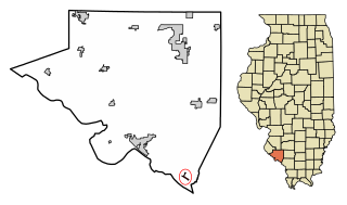
Rockwood is a village in Randolph County, Illinois, United States. The population was 32 at the 2020 census. It is the headquarters of the Middle Mississippi River National Wildlife Refuge.

<span class="mw-page-title-main">Grand Isle, Maine</span> Town in the state of Maine, United States

Grand Isle is a town in Aroostook County, Maine, United States. The population was 366 at the 2020 census. The village of Grand Isle is in the northwestern part of the town.

<span class="mw-page-title-main">Memphis, Nebraska</span> Village in Nebraska, United States

Memphis is a village in Saunders County, Nebraska, United States. The population was 109 at the 2020 census.

<span class="mw-page-title-main">Firthcliffe, New York</span> CDP in New York, United States

Firthcliffe is a hamlet in Orange County, New York United States. The population was 5,022 at the 2020 Census. It is part of the Poughkeepsie–Newburgh–Middletown, NY Metropolitan Statistical Area as well as the larger New York–Newark–Bridgeport, NY-NJ-CT-PA Combined Statistical Area.

<span class="mw-page-title-main">Orange, Ohio</span> Village in Ohio, United States

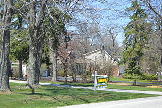
Orange is a village in eastern Cuyahoga County, Ohio, United States. The population was 3,421 at the 2020 census. An affluent eastern suburb of Cleveland, it is part of the Cleveland metropolitan area.

<span class="mw-page-title-main">Miltonsburg, Ohio</span> Village in Ohio, United States

Miltonsburg is a village in Monroe County, Ohio, United States. The population was 42 at the 2020 census. Miltonsburg was named after Milton Pierson, son of Ohio pioneer David Pierson. David Pierson named Clarington, Ohio after his daughter Clarinda.

<span class="mw-page-title-main">Navarre, Ohio</span> Village in Ohio, United States

Navarre is a village in southwestern Stark County, Ohio, United States. The population was 1,846 at the 2020 census. It is part of the Canton–Massillon metropolitan area.

<span class="mw-page-title-main">Butlerville, Ohio</span> Village in Ohio, United States

Butlerville is a village in central Harlan Township, Warren County, Ohio, United States, located in the southwestern part of the state. The population was 155 at the 2020 census.

<span class="mw-page-title-main">Mill Village, Pennsylvania</span> Borough in Pennsylvania, United States

Mill Village is a borough in Erie County, Pennsylvania, United States. The population was 394 at the 2020 census, down from 412 during the 2010 census. It is part of the Erie Metropolitan Statistical Area.

<span class="mw-page-title-main">Clearview, West Virginia</span> Village in West Virginia, United States

Clearview is a village in Ohio County, West Virginia, United States. It is part of the Wheeling, West Virginia Metropolitan Statistical Area. The population was 565 at the 2010 census.

<span class="mw-page-title-main">Brokaw, Wisconsin</span> Village in Wisconsin, United States

Brokaw is a former village in Marathon County, Wisconsin, United States. It is part of the Wausau, Wisconsin Metropolitan Statistical Area. The population was 251 at the 2010 census. Brokaw merged with the village of Maine, Wisconsin on October 1, 2018.

<span class="mw-page-title-main">Marathon City, Wisconsin</span> Village in Wisconsin, United States

Marathon City is a village in Marathon County, Wisconsin, United States. It is part of the Wausau, Wisconsin Metropolitan Statistical Area. The population was 1,524 at the 2010 census. The village was incorporated from a part of the original area of the town of Marathon. The village dates back to 1856. The name of the village commemorates the Battle of Marathon.

<span class="mw-page-title-main">Whiting, Wisconsin</span> Village in Wisconsin, United States

Whiting is a village in Portage County, Wisconsin, United States and is a suburb of Stevens Point. It is included in the Stevens Point Micropolitan Statistical Area. The population was 1,601 at the 2020 census.

<span class="mw-page-title-main">Kingston, Wisconsin</span> Village in Wisconsin, United States

Kingston is a village in Green Lake County, Wisconsin, United States. The population was 326 at the 2010 census. The village is located within the Town of Kingston. The unincorporated community of Dalton, Wisconsin is near Kingston.

<span class="mw-page-title-main">Black Earth, Wisconsin</span> Village in Wisconsin, United States

Black Earth is a village in Dane County, Wisconsin, United States. The population was 1,338 at the 2010 census. The village is located within the Town of Black Earth. It is part of the Madison Metropolitan Statistical Area.

<span class="mw-page-title-main">Arena, Wisconsin</span> Village in Wisconsin, United States

Arena is a village in Iowa County, Wisconsin, United States. The population was 834 at the 2010 census. The village is located within the Town of Arena. It is part of the Madison Metropolitan Statistical Area.

The Town of Weston is located in Marathon County, Wisconsin, United States. It is part of the Wausau, Wisconsin Metropolitan Statistical Area. The population was 657 at the 2020 census.

<span class="mw-page-title-main">Almond, Wisconsin</span> Village in the United States

Almond is a village in Portage County, Wisconsin, United States. The population was 448 at the 2010 census.

<span class="mw-page-title-main">Ironton, Wisconsin</span> Village in Wisconsin, United States

Ironton is a village in Sauk County, Wisconsin, United States, along the Little Baraboo River. The population was 253 at the 2010 census. The village is located within the Town of Ironton.

References

  1. "2019 U.S. Gazetteer Files". United States Census Bureau. Retrieved August 7, 2020.
  2. 1 2 "US Board on Geographic Names". United States Geological Survey. October 25, 2007. Retrieved January 31, 2008.
  3. 1 2 "U.S. Census website". United States Census Bureau . Retrieved November 18, 2012.
  4. 1 2 "U.S. Census website". United States Census Bureau . Retrieved January 31, 2008.
  5. "US Gazetteer files: 2010, 2000, and 1990". United States Census Bureau. February 12, 2011. Retrieved April 23, 2011.
  6. "US Gazetteer files 2010". United States Census Bureau. Archived from the original on January 25, 2012. Retrieved November 18, 2012.
  7. "Census of Population and Housing". Census.gov. Retrieved June 4, 2015.