History
The "Big Spring" on the Mount Vernon Creek branch of the Sugar River is located in what is now Donald Park. The "Big Spring" has been known since at least the 1800s and is one of the features that made Mount Vernon an attractive place for settlement. A cabin built near the "Big Spring" is currently the subject of an archaeological dig and dates from the 1840s. The cabin is believed to be the home of the George Patchin family who were the first Western settlers in the area after migrating from Ohio in 1846.
In 1847, the Britts family acquired 200 acres of land in the area and built a mill on the river. Having migrated from Virginia, the Britt family named their settlement Mount Vernon after Mount Vernon, Virginia. The village was platted in 1850. By 1852, there were 12 families living in Mount Vernon. The Hotel De Allen, which had a saloon and a stable, was built on the West side of the river.
In 1858, a grist mill was built on the river. Farmers from the region brought grain into town to have it milled and bought supplies from the general store. Men hauling lead from Western Wisconsin to Milwaukee often stayed in town as well.
In 1852, much of the Britts land and additional adjoining lands were acquired by Dr. Philander Byam and his two brothers, and Byam's Addition to Mount Vernon was platted. The Byams came to be infamous for their fraudulent business dealings. They sold to local farmers worthless "patent rights." They also sold village lots for exorbitant prices to buyers in New York State using false and misleading sales materials. In one example, they showed a picture of Mount Vernon with a large settlement and a steamboat on the Sugar River. The river is actually only 15–20 feet wide and 1–2 feet deep in most areas.
On October 24, 1859, a group of approximately 70 residents held a meeting, and the group proceeded to Dr. Byam's residence to request his attendance at the meeting. [3] Dr. Byam's wife falsely claimed that he was not at home, so the citizens began to tear down Dr. Byam's house until he eventually came outside. The group proceeded to the mill where a trial was held. The verdict was that the Byams were given the option to leave within 24 hours or to stay and be hanged. One of the Byam brothers was tarred and feathered. The Byams left town the next morning, but one of the brothers returned the next day for a load of hay. The townspeople spotted him and burned the hay wagon.
By 1880, the village had over 100 residents. Local businesses included two hotels with saloons, a leather goods and tanning shop, the general store, a shoe shop, a blacksmith shop, and a slaughter house.
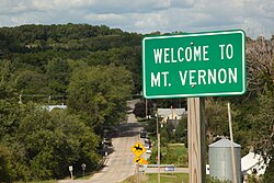
Today, the community consists of several homes and small businesses, a church, and a small park.
White County is a county located in the U.S. state of Illinois. According to the 2020 census, it had a population of 13,877. Its county seat is Carmi. It is located in the southern portion of Illinois known locally as "Little Egypt".

Mount Vernon is a town and the county seat of Franklin County, Texas, United States. The population was 2,491 at the 2020 United States census.

Chippewa Falls is a city located on the Chippewa River in Chippewa County in the northwestern part of the U.S. state of Wisconsin. The population was 14,778 in the 2021 census. Incorporated as a city in 1869, it is the county seat of Chippewa County.

The Town of Albion is located in Dane County, Wisconsin, United States. The population was 2,069 at the 2020 Census. The unincorporated communities of Albion, Highwood, Hillside, and Indian Heights are located in the town.
Sheldon is a village in Rusk County, Wisconsin, United States. The population was 237 at the 2010 census.

Gilman is a village in Taylor County, Wisconsin, United States. The population was 410 at the 2010 census. The village is located between the towns of Aurora and Ford.

Aztalan State Park is a Wisconsin state park in the Town of Aztalan, Jefferson County. Established in 1952, it was designated a National Historic Landmark in 1964 and added to the National Register of Historic Places in 1966. The park covers 172 acres (70 ha) along the Crawfish River.

Cumberland is a city in Barron County in the U.S. state of Wisconsin. The population was 2,170 at the 2010 census. The city is located partially within the Town of Cumberland. It was incorporated in 1885.

Cedarburg is a town in Ozaukee County, Wisconsin, United States, and is in the Milwaukee metropolitan area. The town was created in 1849 and at the time of the 2020 census had a population of 6,162.

Arpin is a village in Wood County, Wisconsin, United States. The population was 333 at the 2010 census.

Winter Quarters was an encampment formed by approximately 2,500 members of the Church of Jesus Christ of Latter-day Saints as they waited during the winter of 1846–47 for better conditions for their trek westward. It followed a preliminary tent settlement some 3½ miles west at Cutler's Park. Members of the LDS faith built more than 800 cabins at the Winter Quarters settlement. Located in present-day North Omaha overlooking the Missouri River, the settlement remained populated until 1848.

The Military Ridge State Trail is a 40-mile (64 km) long, recreational rail trail in Wisconsin.

Ivanpah was a short-lived silver mining town located in San Bernardino County, California, United States. It was founded in 1869 and existed until at least the mid-1880s.

Old Colorado City, formerly Colorado City, was once a town, but it is now a neighborhood within the city of Colorado Springs, Colorado. Its commercial district was listed on the National Register of Historic Places in 1982. It was founded during the Pikes Peak Gold Rush of 1859 and was involved in the mining industry, both as a supply hub and as a gold ore processing center beginning in the 1890s. Residents of Colorado City worked at some of the 50 coal mines of the Colorado Springs area. It was briefly the capital of the Colorado Territory. For many years, Colorado Springs prohibited the use of alcohol within its border due to the lifestyle of Colorado City's opium dens, bordellos, and saloons. It is now a tourist area, with boutiques, art galleries, and restaurants.

Beaver is an unincorporated community in Whitewater Township, Winona County, Minnesota, United States, located near the junction of State Highway 74 and Winona County Road 30. Nearby places include Altura, Elba, Plainview, St. Charles, Weaver, and Whitewater State Park. The Whitewater River and Beaver Creek both flow through the area.
Leavenworth is an unincorporated community located in Leavenworth Township in Brown County, Minnesota, United States. The elevation is 1,004 feet. It was situated on two locations in Brown County, one before the Dakota War of 1862, and in section 27 of the township along the Cottonwood River after the war.
Pfister & Vogel (P&V) was an American tannery business in Milwaukee, Wisconsin.
New Cassel or New Cassell, formerly Crouchville, was a village on the Milwaukee River in the northwestern corner of the Town of Auburn in Fond du Lac County, Wisconsin. It was eventually absorbed into Campbellsport, Wisconsin after the latter was incorporated in 1902, and now constitutes the east end of that village.

Canadiana Village is a heritage park north of Montreal near Rawdon, Quebec. About 15% of the land is used to depict a 19th-century western town and rural village in Quebec. The rest of the site consists of lush forest, brooks, river, and mountain. Canadiana Village endeavours to depict life in a pioneer Quebec Canadian settlement during the 19th century. Featured at the site are over 40 historical buildings, with over 38 original buildings more than 100 years old. The Copping homestead, was built on what was later the site of Canadiana Village. The buildings in the western town and rural village include a church, a general store, a mill, a cemetery, a saloon and 22 houses. There are old tractors and threshing machines, props and decoration items for movie set. The Canadiana Village was closed to the public in 1996.

The Old World Third Street Historic District is the last relatively intact part of the original German retail district in Milwaukee, Wisconsin's Kilbourntown plat, containing examples of various styles of Victorian commercial architecture going back to 1855. It was listed on the National Register of Historic Places in 1987 and on the State Register of Historic Places in 1989.