Echo sounding

Last updated

Illustration of echo sounding using a multibeam echosounder. Echo Sounding USN.jpg
Illustration of echo sounding using a multibeam echosounder.
The MTVZA sounder received from the Meteor M2-2 satellite by an amateur station METEORSOUNDER.png
The MTVZA sounder received from the Meteor M2-2 satellite by an amateur station

Echo sounding or depth sounding is the use of sonar for ranging, normally to determine the depth of water (bathymetry). It involves transmitting acoustic waves into water and recording the time interval between emission and return of a pulse; the resulting time of flight, along with knowledge of the speed of sound in water, allows determining the distance between sonar and target. This information is then typically used for navigation purposes or in order to obtain depths for charting purposes.

Contents

Echo sounding can also be used for ranging to other targets, such as fish schools. Hydroacoustic assessments have traditionally employed mobile surveys from boats to evaluate fish biomass and spatial distributions. Conversely, fixed-location techniques use stationary transducers to monitor passing fish.

The word sounding is used for all types of depth measurements, including those that don't use sound, and is unrelated in origin to the word sound in the sense of noise or tones. Echo sounding is a more rapid method of measuring depth than the previous technique of lowering a sounding line until it touched bottom.

History

German inventor Alexander Behm was granted German patent No. 282009 for the invention of echo sounding (device for measuring depths of the sea and distances and headings of ships or obstacles by means of reflected sound waves) on 22 July 1913. [1] [2] [3] Meanwhile, in France, physicist Paul Langevin (connected with Marie Curie) and better known for his research work in nuclear physics was recruited by french navy laboratories at the beginning of WW 2 and conducted (then secret) research on active sonars for anti-submarine warfare (using a piezoelectric transmitter) . His work was developed and implemented by other scientists and technnicians such as Chilowski, Florisson and Pierre Marti. Though a fully operational échosondeur (sonar) was not ready for use in wartime, successful trials both off Toulon and in the Manche (Channel)took place as early as 1920 and french patents taken for civilian uses. Oceanographic ships and french High-sea fishing assistance vessels were equipped with Langevin-Florisson and Langevin Marti recording sonars as early as the mid/late 20s [4]

One of the first commercial echo sounding units was the Fessenden Fathometer, which used the Fessenden oscillator to generate sound waves. This was first installed by the Submarine Signal Company in 1924 on the M&M liner S.S. Berkshire. [5]

Technique

Diagram showing the basic principle of echo sounding Principle of SBES.svg
Diagram showing the basic principle of echo sounding

Distance is measured by multiplying half the time from the signal's outgoing pulse to its return by the speed of sound in the water, which is approximately 1.5 kilometres per second [T÷2×(4700 feet per second or 1.5 km per second )] For precise applications of echosounding, such as hydrography, the speed of sound must also be measured typically by deploying a sound velocity probe into the water. Echo sounding is effectively a special purpose application of sonar used to locate the bottom. Since a traditional pre-SI unit of water depth was the fathom, an instrument used for determining water depth is sometimes called a fathometer.

Most charted ocean depths use an average or standard sound speed. Where greater accuracy is required average and even seasonal standards may be applied to ocean regions. For high accuracy depths, usually restricted to special purpose or scientific surveys, a sensor may be lowered to measure the temperature, pressure and salinity. These factors are used to calculate the actual sound speed in the local water column. This latter technique is regularly used by US Office of Coast Survey for navigational surveys of US coastal waters. [6]

Types

Single beam

beam shape of a single-beam echosounder on a USV SINGLE-BEAM-ECHOSOUNDER-1.jpg
beam shape of a single-beam echosounder on a USV

A single-beam echo sounder is one of the simplest and most fundamental types of underwater sonar. They are ubiquitous in the boating world and used on a number of different marine robotic vehicles. It operates by using a transducer to emit a pulse through the water and listen for echos to return. Using that data, it's able to determine the distance from the strongest echo, which can be the seafloor, a concrete structure, or other larger obstacle. [7] A fishfinder is an echo sounding device used by both recreational and commercial fishers.

Multibeam

Multibeam sonar is used to map the ocean floor Fis01334 (27555144884).jpg
Multibeam sonar is used to map the ocean floor
A multibeam echosounder (MBES) is a type of sonar that is used to map the seabed. It emits acoustic waves in a fan shape beneath its transceiver. The time it takes for the sound waves to reflect off the seabed and return to the receiver is used to calculate the water depth. Unlike other sonars and echo sounders, MBES uses beamforming to extract directional information from the returning soundwaves, producing a swathe of depth soundings from a single ping.

Common use

As well as an aid to navigation (most larger vessels will have at least a simple depth sounder), echo sounding is commonly used for fishing. Variations in elevation often represent places where fish congregate. Schools of fish will also register. [8]

Hydrography

In areas where detailed bathymetry is required, a precise echo sounder may be used for the work of hydrography. There are many considerations when evaluating such a system, not limited to the vertical accuracy, resolution, acoustic beamwidth of the transmit/receive beam and the acoustic frequency of the transducer.

An example of a precision dual frequency echosounder, the Teledyne Odom MkIII Odom Mk3 Echosounder.jpg
An example of a precision dual frequency echosounder, the Teledyne Odom MkIII

The majority of hydrographic echosounders are dual frequency, meaning that a low frequency pulse (typically around 24 kHz) can be transmitted at the same time as a high frequency pulse (typically around 200 kHz). As the two frequencies are discrete, the two return signals do not typically interfere with each other. There are many advantages of dual frequency echosounding, including the ability to identify a vegetation layer or a layer of soft mud on top of a layer of rock.

A screen grab of the difference between single and dual frequency echograms DF SBES Wiki.jpg
A screen grab of the difference between single and dual frequency echograms

Most hydrographic operations use a 200 kHz transducer, which is suitable for inshore work up to 100 metres in depth. Deeper water requires a lower frequency transducer as the acoustic signal of lower frequencies is less susceptible to attenuation in the water column. Commonly used frequencies for deep water sounding are 33 kHz and 24 kHz.

The beamwidth of the transducer is also a consideration for the hydrographer, as to obtain the best resolution of the data gathered a narrow beamwidth is preferable. The higher the operating frequency, the narrower the beamwidth. Therefore, it is especially important when sounding in deep water, as the resulting footprint of the acoustic pulse can be very large once it reaches a distant sea floor.

A multispectral multibeam echosounder is an extension of a dual frequency vertical beam echosounder in that, as well as measuring two soundings directly below the sonar at two different frequencies; it measures multiple soundings at multiple frequencies, at multiple different grazing angles, and multiple different locations on the seabed. These systems are detailed further in the section called multibeam echosounder.

Echo sounders are used in laboratory applications to monitor sediment transport, scour and erosion processes in scale models (hydraulic models, flumes etc.). These can also be used to create plots of 3D contours.

Standards for hydrographic echo sounding

The required precision and accuracy of the hydrographic echo sounder is defined by the requirements of the International Hydrographic Organization (IHO) for surveys that are to be undertaken to IHO standards. [9] These values are contained within IHO publication S44.

In order to meet these standards, the surveyor must consider not only the vertical and horizontal accuracy of the echo sounder and transducer, but the survey system as a whole. A motion sensor may be used, specifically the heave component (in single beam echosounding) to reduce soundings for the motion of the vessel experienced on the water's surface. Once all of the uncertainties of each sensor are established, the hydrographer will create an uncertainty budget to determine whether the survey system meets the requirements laid down by IHO.

Different hydrographic organisations will have their own set of field procedures and manuals to guide their surveyors to meet the required standards. Two examples are the US Army Corps of Engineers publication EM110-2-1003, [10] and the NOAA 'Field Procedures Manual'. [11]

See also

Related Research Articles

<span class="mw-page-title-main">Challenger Deep</span> Deepest-known point of Earths seabed

The Challenger Deep is the deepest known point of the seabed of Earth, located in the western Pacific Ocean at the southern end of the Mariana Trench, in the ocean territory of the Federated States of Micronesia. According to the GEBCO Gazetteer of Undersea Feature Names the depression's depth is 10,920 ± 10 m (35,827 ± 33 ft) at 11°22.4′N142°35.5′E, although its exact geodetic location remains inconclusive and its depth has been measured at 10,902–10,929 m (35,768–35,856 ft) by deep-diving submersibles, remotely operated underwater vehicles, benthic landers, and sonar bathymetry. The differences in depth estimates and their geodetic positions are scientifically explainable by the difficulty of researching such deep locations.

<span class="mw-page-title-main">Sonar</span> Acoustic sensing method

Sonar is a technique that uses sound propagation to navigate, measure distances (ranging), communicate with or detect objects on or under the surface of the water, such as other vessels.

<span class="mw-page-title-main">Side-scan sonar</span> Tool for seafloor mapping

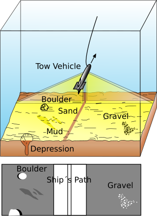
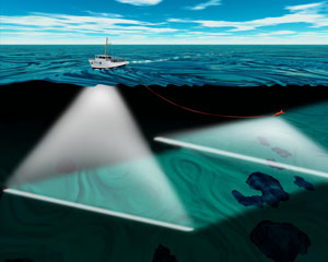
Side-scan sonar is a category of sonar system that is used to efficiently create an image of large areas of the sea floor.

<span class="mw-page-title-main">Hydrography</span> Applied science of measurement and description of physical features of bodies of water

Hydrography is the branch of applied sciences which deals with the measurement and description of the physical features of oceans, seas, coastal areas, lakes and rivers, as well as with the prediction of their change over time, for the primary purpose of safety of navigation and in support of all other marine activities, including economic development, security and defense, scientific research, and environmental protection.

<span class="mw-page-title-main">Hydrographic survey</span> Science of measurement and description of features which affect maritime activities

Hydrographic survey is the science of measurement and description of features which affect maritime navigation, marine construction, dredging, offshore wind farms, offshore oil exploration and drilling and related activities. Surveys may also be conducted to determine the route of subsea cables such as telecommunications cables, cables associated with wind farms, and HVDC power cables. Strong emphasis is placed on soundings, shorelines, tides, currents, seabed and submerged obstructions that relate to the previously mentioned activities. The term hydrography is used synonymously to describe maritime cartography, which in the final stages of the hydrographic process uses the raw data collected through hydrographic survey into information usable by the end user.

<span class="mw-page-title-main">Bathymetric chart</span> Map depicting the submerged terrain of bodies of water

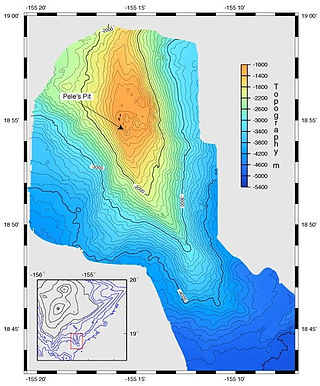
A bathymetric chart is a type of isarithmic map that depicts the submerged topography and physiographic features of ocean and sea bottoms. Their primary purpose is to provide detailed depth contours of ocean topography as well as provide the size, shape and distribution of underwater features. Topographic maps display elevation above ground and are complementary to bathymetric charts. Charts use a series of lines and points at equal intervals to showcase depth or elevation. A closed shape with increasingly smaller shapes inside of it can indicate an ocean trench or a seamount, or underwater mountain, depending on whether the depths increase or decrease going inward.

<span class="mw-page-title-main">Bathymetry</span> Study of underwater depth of lake or ocean floors

Bathymetry is the study of underwater depth of ocean floors, lake floors, or river floors. In other words, bathymetry is the underwater equivalent to hypsometry or topography. The first recorded evidence of water depth measurements are from Ancient Egypt over 3000 years ago. Bathymetric charts, are typically produced to support safety of surface or sub-surface navigation, and usually show seafloor relief or terrain as contour lines and selected depths (soundings), and typically also provide surface navigational information. Bathymetric maps may also use a Digital Terrain Model and artificial illumination techniques to illustrate the depths being portrayed. The global bathymetry is sometimes combined with topography data to yield a global relief model. Paleobathymetry is the study of past underwater depths.

<span class="mw-page-title-main">Fishfinder</span> Electronic device used in water

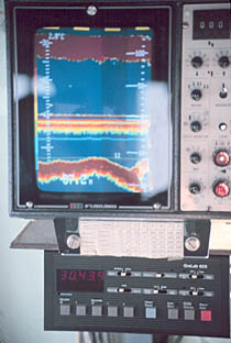
A fishfinder or sounder (Australia) is an instrument used to locate fish underwater by detecting reflected pulses of sound energy, as in sonar. A modern fishfinder displays measurements of reflected sound on a graphical display, allowing an operator to interpret information to locate schools of fish, underwater debris, and the bottom of a body of water. Fishfinder instruments are used both by sport and commercial fishermen. Modern electronics allow a high degree of integration between the fishfinder system, marine radar, compass and GPS navigation systems.

<span class="mw-page-title-main">Multibeam echosounder</span> Type of sonar used to map the seabed

A multibeam echosounder (MBES) is a type of sonar that is used to map the seabed. It emits acoustic waves in a fan shape beneath its transceiver. The time it takes for the sound waves to reflect off the seabed and return to the receiver is used to calculate the water depth. Unlike other sonars and echo sounders, MBES uses beamforming to extract directional information from the returning soundwaves, producing a swathe of depth soundings from a single ping.

<span class="mw-page-title-main">Underwater acoustics</span> Study of the propagation of sound in water

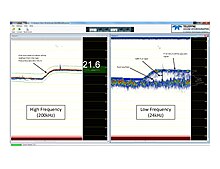
Underwater acoustics is the study of the propagation of sound in water and the interaction of the mechanical waves that constitute sound with the water, its contents and its boundaries. The water may be in the ocean, a lake, a river or a tank. Typical frequencies associated with underwater acoustics are between 10 Hz and 1 MHz. The propagation of sound in the ocean at frequencies lower than 10 Hz is usually not possible without penetrating deep into the seabed, whereas frequencies above 1 MHz are rarely used because they are absorbed very quickly.

<span class="mw-page-title-main">Ultrasonic transducer</span> Acoustic sensor

Ultrasonic transducers and ultrasonic sensors are devices that generate or sense ultrasound energy. They can be divided into three broad categories: transmitters, receivers and transceivers. Transmitters convert electrical signals into ultrasound, receivers convert ultrasound into electrical signals, and transceivers can both transmit and receive ultrasound.

Acoustic seabed classification is the partitioning of a seabed acoustic image into discrete physical entities or classes. This is a particularly active area of development in the field of seabed mapping, marine geophysics, underwater acoustics and benthic habitat mapping. Seabed classification is one route to characterizing the seabed and its habitats. Seabed characterization makes the link between the classified regions and the seabed physical, geological, chemical or biological properties. Acoustic seabed classification is possible using a wide range of acoustic imaging systems including multibeam echosounders, sidescan sonar, single-beam echosounders, interferometric systems and sub-bottom profilers. Seabed classification based on acoustic properties can be divided into two main categories; surficial seabed classification and sub-surface seabed classification. Sub-surface imaging technologies use lower frequency sound to provide higher penetration, whereas surficial imaging technologies provide higher resolution imagery by utilizing higher frequencies.

<span class="mw-page-title-main">Fisheries acoustics</span>

Fisheries acoustics includes a range of research and practical application topics using acoustical devices as sensors in aquatic environments. Acoustical techniques can be applied to sensing aquatic animals, zooplankton, and physical and biological habitat characteristics.

<span class="mw-page-title-main">Depth sounding</span> Measuring the depths of a body of water

Depth sounding, often simply called sounding, is measuring the depth of a body of water. Data taken from soundings are used in bathymetry to make maps of the floor of a body of water, such as the seabed topography.

A sound velocity probe is a device that is used for measuring the speed of sound, specifically in the water column, for oceanographic and hydrographic research purposes.

RESON A/S is a Danish company which provides tools for underwater acoustic applications and survey accuracy requirements.

<span class="mw-page-title-main">Nicholas H. Heck</span> American USCGSC officer (1882–1953)

Captain Nicholas Hunter Heck was a career officer of the United States Coast and Geodetic Survey Corps. A leading geophysicist of his time, Heck made important contributions in the study of seismology and oceanography. He also revolutionized hydrographic surveying by developing the wire-drag surveying technique and introduced radio acoustic ranging into Coast and Geodetic Survey hydrography.

<span class="mw-page-title-main">Radio acoustic ranging</span> Method of accurately determining a ships position

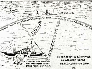
Radio acoustic ranging, occasionally written as "radio-acoustic ranging" and sometimes abbreviated RAR, was a method for determining a ship's precise location at sea by detonating an explosive charge underwater near the ship, detecting the arrival of the underwater sound waves at remote locations, and radioing the time of arrival of the sound waves at the remote stations to the ship, allowing the ship's crew to use true range multilateration to determine the ship's position. Developed by the United States Coast and Geodetic Survey in 1923 and 1924 for use in accurately fixing the position of survey ships during hydrographic survey operations, it was the first navigation technique in human history other than dead reckoning that did not require visual observation of a landmark, marker, light, or celestial body, and the first non-visual means to provide precise positions. First employed operationally in 1924, radio acoustic ranging remained in use until 1944, when new radio navigation techniques developed during World War II rendered it obsolete.

<span class="mw-page-title-main">Underwater survey</span> Inspection or measurement in or of an underwater environment

An underwater survey is a survey performed in an underwater environment or conducted remotely on an underwater object or region. Survey can have several meanings. The word originates in Medieval Latin with meanings of looking over and detailed study of a subject. One meaning is the accurate measurement of a geographical region, usually with the intention of plotting the positions of features as a scale map of the region. This meaning is often used in scientific contexts, and also in civil engineering and mineral extraction. Another meaning, often used in a civil, structural, or marine engineering context, is the inspection of a structure or vessel to compare actual condition with the specified nominal condition, usually with the purpose of reporting on the actual condition and compliance with, or deviations from, the nominal condition, for quality control, damage assessment, valuation, insurance, maintenance, and similar purposes. In other contexts it can mean inspection of a region to establish presence and distribution of specified content, such as living organisms, either to establish a baseline, or to compare with a baseline.

<span class="mw-page-title-main">Underwater exploration</span> Investigating or traveling around underwater for the purpose of discovery

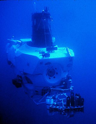
Underwater exploration is the exploration of any underwater environment, either by direct observation by the explorer, or by remote observation and measurement under the direction of the investigators. Systematic, targeted exploration is the most effective method to increase understanding of the ocean and other underwater regions, so they can be effectively managed, conserved, regulated, and their resources discovered, accessed, and used. Less than 10% of the ocean has been mapped in any detail, less has been visually observed, and the total diversity of life and distribution of populations is similarly obscure.

References

  1. Salous, Sana (2013). Radio Propagation Measurement and Channel Modelling. John Wiley & Sons. p. 424. ISBN   9781118502327.
  2. Xu, Guochang (2010). Sciences of Geodesy - I: Advances and Future Directions. Springer Publishing. p. 281. ISBN   9783642117411.
  3. Werner Schneider. "Alexander Behm - Der Erfinder des Echolots" . Retrieved 9 April 2014.
  4. https://www.academia.edu/1182631/Paul_Langevin_et_la_detection_sous-marine_1914-1929._Un_physicien_acteur_de_l_innovation_industrielle_et_militaire_Epistemologiques_2001_
  5. "Fessenden Fathometer amplifier - Submarine Signal Company". The Subchaser Archives. 20 March 2007. Retrieved 12 April 2018.
  6. See NOAA Field Procedures Manual, Office of Coast Survey website (http://www.nauticalcharts.noaa.gov/hsd/fpm/fpm.htm Archived 10 August 2011 at the Wayback Machine )
  7. "A Smooth Operator's Guide to Underwater Sonars and Acoustic Devices". Blue Robotics. Retrieved 12 January 2024.
  8. "Fishfinders Guide" (in German). Retrieved 16 February 2017.
  9. International Hydrographic Bureau (February 2008). "IHO Standards for Hydrographic Surveys" (PDF) (5th Edition). Archived from the original (PDF) on 8 October 2011.{{cite journal}}: Cite journal requires |journal= (help)
  10. "EM 1110-2-1003 (01 Jan 02)". Archived from the original on 20 July 2011. Retrieved 9 June 2011., USACE publication EM 1110-2-1003.
  11. Archived 16 May 2011 at the Wayback Machine , NOAA Field Procedures Manual.

Commons-logo.svg Media related to Echo sounding at Wikimedia Commons