Extreme points of Wales

Last updated

This is a list of the extreme points and extreme elevations in Wales.

Contents

Wales

Middle Mouse (Ynys Badrig) as seen from Anglesey (Ynys Mon) MiddleMouse.jpg
Middle Mouse (Ynys Badrig) as seen from Anglesey (Ynys Môn)

Wales (mainland)

Chepstow showing border Chepstow Castle and Bridge from Tutshill.jpg
Chepstow showing border

Centre point

The centre point of Wales is dependent on whether only the mainland is used for calculation or outlying islands as well.

One centre point is calculated to be near Cwmystwyth, Devil's Bridge, Ceredigion ( 52°19′48.791″N3°45′59.072″W / 52.33021972°N 3.76640889°W / 52.33021972; -3.76640889 (Centre of Wales) ; grid reference SN7972871704 ) [1]

Elevation extremes

Snowdon seen from Llyn Llydaw Snowdon from Llyn Llydaw.jpg
Snowdon seen from Llyn Llydaw

Many points are on, or near sea level, but due to high rainfall, there are no natural dry pieces of land below sea level - see rivers and lakes below.

Rivers and lakes

The largest natural lake in Wales is Bala Lake (Llyn Tegid). Llangorse Lake is second largest by area.

The River Usk is the longest river to flow wholly within Wales. The table below lists Wales' longest rivers [2] including (in italics) those only partly in Wales.

RiverTotal lengthLength in Wales
(miles)(km)(miles)(km)
1 River Severn 22035448 [3] 77
2 River Wye [4] 155250
3 River Teme [5] 811301219
4 River Usk [6] 7812578125
5 River Teifi [7] 7612276122
6 River Towy [8] 7512075120
7 River Dee [9] 70112
8 River Taff 40644064

See also

Related Research Articles

<span class="mw-page-title-main">Geography of France</span> Overview of the geography of France

The geography of France consists of a terrain that is mostly flat plains or gently rolling hills in the north and west and mountainous in the south and the east. Metropolitan France has a total size of 551,695 km2 (213,011 sq mi). It is the third largest country in Europe by area and the largest in Western Europe.

<span class="mw-page-title-main">Arctic Archipelago</span> Canadian islands in the Arctic Ocean

The Arctic Archipelago, also known as the Canadian Arctic Archipelago, is an archipelago lying to the north of the Canadian continental mainland, excluding Greenland and Iceland.

<span class="mw-page-title-main">Extreme points of Ireland</span>

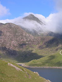
This is a list of the extreme points of Ireland – the points that are furthest north, south, east or west in Ireland. It includes the Republic of Ireland and Northern Ireland.

<span class="mw-page-title-main">Extreme points of North America</span> Most prominent locations of the continents physical boundaries

This is a list of the extreme points of North America: the points that are highest and lowest, and farther north, south, east or west than any other location on the continent. Some of these points are debatable, given the varying definitions of North America.

Beryozovka or Berezovka is the name of several inhabited localities in Russia.

Belyayevo is the name of several rural localities in Russia.

This is a list of the extreme points and extreme elevations in Scotland.

Oktyabrsky, Oktyabrskaya or Oktyabrskoye is the name of several inhabited localities in Russia.

<span class="mw-page-title-main">Extreme points of Catalonia</span> Catalan Geographical Areas

This is a list of the extreme points of Catalonia, the points that are farther north, south, east or west than any other location, as well as the highest point in the autonomous community.

Otradny, Otradnaya, or Otradnoye is the name of several inhabited localities in Russia.

Andreyevsky, Andreyevskaya, or Andreyevskoye is the name of several rural localities in Russia.

Stepanovsky, Stepanovskaya, or Stepanovskoye is the name of several rural localities in Russia.

References

  1. "Saving the centre of Wales". BBC. 24 October 2002. Retrieved 4 January 2010.
  2. "Wales"  . Encyclopædia Britannica . Vol. 28 (11th ed.). 1911. p. 258 to 270.
  3. "The longest rivers in Wales". Discovery. Discovery channel. Retrieved 1 April 2024.
  4. "SSSI Citation River Wye (upper Wye)" (PDF). Natural Resources Wales. Retrieved 14 November 2020.
  5. "Teme Valley". Abberley and Malvern Hills Geopark. AMHG. Retrieved 1 April 2024.
  6. "Usk Management Catchment Summary" (PDF). Natural Resources Wales. Retrieved 25 April 2020.
  7. "River Teifi". Countryside Council for Wales. Archived from the original on 21 February 2014. Retrieved 14 November 2020.
  8. Davies, John; Jenkins, Nigel; Baines, Menna; Lynch, Peredur I., eds. (2008). The Welsh Academy Encyclopaedia of Wales . Cardiff: University of Wales Press. p. 894. ISBN   978-0-7083-1953-6.{{cite encyclopedia}}: Missing or empty |title= (help)
  9. "Dee (Wales)"  . Encyclopædia Britannica . Vol. 07 (11th ed.). 1911. p. 921.