This article needs additional citations for verification .(January 2010) |
The following is a list of notable mountain passes in Wales:
This article needs additional citations for verification .(January 2010) |
The following is a list of notable mountain passes in Wales:

New South Wales is a state on the east coast of Australia. It borders Queensland to the north, Victoria to the south, and South Australia to the west. Its coast borders the Coral and Tasman Seas to the east. The Australian Capital Territory and Jervis Bay Territory are enclaves within the state. New South Wales' state capital is Sydney, which is also Australia's most populous city. In December 2023, the population of New South Wales was over 8.3 million, making it Australia's most populous state. Almost two-thirds of the state's population, 5.3 million, live in the Greater Sydney area.

Snowdonia, or Eryri, is a mountainous region and national park in North Wales. It contains all 15 mountains in Wales over 3000 feet high, including the country's highest, Snowdon, which is 1,085 metres (3,560 ft) tall. These peaks are all part of the Snowdon, Glyderau, and Carneddau ranges in the north of the region. The shorter Moelwynion and Moel Hebog ranges lie immediately to the south.

The Great Dividing Range, also known as the East Australian Cordillera or the Eastern Highlands, is a cordillera system in eastern Australia consisting of an expansive collection of mountain ranges, plateaus and rolling hills. It runs roughly parallel to the east coast of Australia and forms the fifth-longest land-based mountain chain in the world, and the longest entirely within a single country. It is mainland Australia's most substantial topographic feature and serves as the definitive watershed for the river systems in eastern Australia, hence the name.

The Blue Mountains are a mountainous region and a mountain range located in New South Wales, Australia. The region is considered to be part of the western outskirts of the Greater Sydney area. The region borders on Sydney's main metropolitan area, its foothills starting about 50 kilometres (31 mi) west of centre of the state capital, close to Penrith. The public's understanding of the extent of the Blue Mountains is varied, as it forms only part of an extensive mountainous area associated with the Great Dividing Range. As defined in 1970, the Blue Mountains region is bounded by the Nepean and Hawkesbury rivers in the east, the Coxs River and Lake Burragorang to the west and south, and the Wolgan and Colo rivers to the north. Geologically, it is situated in the central parts of the Sydney Basin.
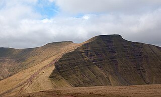
The Brecon Beacons are a mountain range in Wales. The range includes South Wales's highest mountain, Pen y Fan, its twin summit Corn Du, and Craig Gwaun Taf, which are the three highest peaks in the range. The Brecon Beacons have given their name to the larger Brecon Beacons National Park, and the range itself is therefore sometimes known as the Central Beacons to differentiate the two.

The Blue Mountains National Park is a protected national park that is located in the Blue Mountains region of New South Wales, in eastern Australia. The 267,954-hectare (662,130-acre) national park is situated approximately 80 kilometres (50 mi) west of the Sydney CBD, and the park boundary is quite irregular as it is broken up by roads, urban areas and areas of private property. Despite the name mountains, the area is an uplifted plateau, dissected by a number of larger rivers. The highest point in the park is Mount Werong at 1,215 metres (3,986 ft) above sea level; while the low point is on the Nepean River at 20 metres (66 ft) above sea level as it leaves the park.

Powys is a county and preserved county in Wales. It borders Gwynedd, Denbighshire, and Wrexham to the north; the English ceremonial counties of Shropshire and Herefordshire to the east; Monmouthshire, Blaenau Gwent, Merthyr Tydfil, Caerphilly, Rhondda Cynon Taf, and Neath Port Talbot to the south; and Carmarthenshire and Ceredigion to the west. The largest settlement is Newtown, and the administrative centre is Llandrindod Wells.

Snowdon, or Yr Wyddfa, is a mountain in the Snowdonia region of North Wales. It has an elevation of 1,085 metres (3,560 ft) above sea level, which makes it both the highest mountain in Wales and the highest in the British Isles south of the Scottish Highlands. Snowdon is designated a national nature reserve for its rare flora and fauna, and is located within Snowdonia National Park.
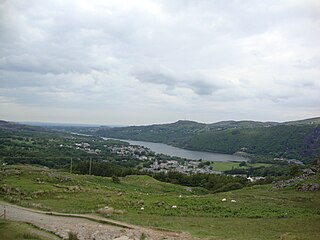
Llanberis is a village, community and electoral ward in Gwynedd, northwest Wales, on the southern bank of the lake Llyn Padarn and at the foot of Snowdon, the highest mountain in Wales. It is a centre for outdoor activities in Snowdonia, including walking, mountaineering, climbing, mountain biking and pony trekking, as well as water sports such as scuba diving. The community includes Nant Peris.

Mountain Ash is a town and former community in the Cynon Valley, within the County Borough of Rhondda Cynon Taf, Wales, with a population of 11,230 at the 2011 Census, estimated in 2019 at 11,339. It includes the districts and villages of Cefnpennar, Cwmpennar, Caegarw, Darranlas, Fernhill, Glenboi and Newtown, all within the historic county boundaries of Glamorgan. Aberdare lies about 4.5 miles (7.2 km) north-west, Cardiff 19 miles (31 km) south-east, and Penrhiwceiber a mile to the south-east. It divides into two communities : West covers the town centre and the districts of Miskin, Darranlas, Fernhill and Glenboi, and East the districts of Cefnpennar, Cwmpennar, Caegarw and Newtown.

Burning Mountain, the common name for Mount Wingen, is a hill near Wingen, New South Wales, Australia, approximately 224 km (139 mi) north of Sydney just off the New England Highway. It takes its name from a smouldering coal seam running underground through the sandstone. Burning Mountain is contained within the Burning Mountain Nature Reserve, which is administered by the NSW National Parks and Wildlife Service (NPWS).

The City of Blue Mountains is a local government area of New South Wales, Australia, governed by the Blue Mountains City Council. The city is located in the Blue Mountains, on the Great Dividing Range at the far western fringe of the Greater Sydney area. Major settlements include, Katoomba, Lawson, Springwood and Blaxland.
The Coxs River, a perennial river that is part of the Hawkesbury-Nepean catchment, is located in the Central Tablelands, Blue Mountains, and Macarthur regions of New South Wales, Australia.

The mountains and hills of the British Isles are categorised into various lists based on different combinations of elevation, prominence, and other criteria such as isolation. These lists are used for peak bagging, whereby hillwalkers attempt to reach all the summits on a given list, the oldest being the 282 Munros in Scotland, created in 1891.

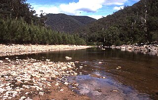
The Tumut River, a perennial stream that is part of the Murrumbidgee catchment within the Murray–Darling basin, is located in the Snowy Mountains and South West Slopes districts of New South Wales, Australia.

The Grose River, a perennial river that is part of the Hawkesbury-Nepean catchment, is located in the Blue Mountains region of New South Wales, Australia.
The Nunnock River, a perennial stream of the Bega River catchment, is located in the Monaro region of New South Wales, Australia.

Grundy Mountain or Mount Grundy, a mountain of the Great Dividing Range, is located on the Northern Tablelands of New South Wales, Australia.
Where not otherwise specified, much information is taken from 1:25,000 and 1:50,000 scale maps published by the Ordnance Survey.
| Physical | |||||||
|---|---|---|---|---|---|---|---|
| Environment | |||||||
| Land use | |||||||
| Administrative |
| ||||||
| Social | |||||||
| Other | |||||||
| Infrastructure |
|
|---|---|
| Governance | |
| Walking | |
| Road | |
| Buses and trams | |
| Water |
|
| Rail | |
| Cycling | |
| Local | |
| Other | |