Florence County is a county located in the U.S. state of Wisconsin. As of the 2020 census, the population was 4,558, making it the second-least populous county in Wisconsin after Menominee County. Its county seat is Florence.
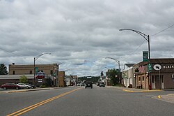
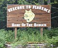
Florence is a town in Florence County, Wisconsin, United States. The population was 2,319 at the 2000 census. The ZIP code is 54121. Florence is also the name of a census-designated place within the town about 11 miles (18 km) northwest of Iron Mountain, Michigan; the community is the county seat of Florence County. The unincorporated communities of Hematite, Pulp, Ridgetop, Spread Eagle, and Tyran are also located in the town.

Neopit is a census-designated place (CDP) in Menominee County, Wisconsin, United States. The population was 616 at the 2020 census. Neopit is located along Wisconsin Highway 47 at its intersection with County Road M, approximately 3 miles (4.8 km) southeast of Zoar. The name derives from the Menominee name Neyōpet which means "four sitting".

Zoar is a census-designated place (CDP) and unincorporated community in Menominee County, Wisconsin, United States. The population was 107 at the 2020 census. Zoar is located along Wisconsin Highway 47, approximately 3 miles (4.8 km) northwest of Neopit. Situated within traditional Menominee territory, it is known in the Menominee language as Saqnawehnaen, a name which refers to a fork in a stream.

Shiocton is a village in Outagamie County, Wisconsin, United States. The population was 921 at the 2010 census. It is wholly surrounded by the Town of Bovina.

Middle Village is a census-designated place (CDP), in the towns of Menominee and Red Springs, in Menominee and Shawano counties in the U.S. state of Wisconsin. It does not have any legal status as an incorporated municipality. The population was 290 at the 2020 census.

Oneida is an unincorporated community and former census-designated place (CDP) in the Town of Oneida, Outagamie County, Wisconsin, United States. The population was 1,070 at the 2000 census. At the census, part of the CDP lay within the Town of Hobart, which has since incorporated as a village, in adjacent Brown County. Oneida is located on Wisconsin Highway 54.

US Highway 141 (US 141) is a north–south United States Numbered Highway in the states of Wisconsin and Michigan. The highway runs north-northwesterly from an interchange with Interstate 43 (I-43) in Bellevue, Wisconsin, near Green Bay, to a junction with US 41/M-28 near Covington, Michigan. In between, it follows city streets in Green Bay and has a concurrent section with US 41 in Wisconsin. North of Green Bay, US 141 is either a freeway or an expressway into rural northern Wisconsin before downgrading to an undivided highway. In Michigan, US 141 is an undivided highway that runs through rural woodlands. The highway has two segments in each state; after running through Wisconsin for about 103 miles (166 km), it crosses into Michigan for approximately another eight miles (13 km). After that, it crosses back into Wisconsin for about 14+1⁄2 miles (23 km) before crossing the state line one last time. The northernmost Michigan section is about 43+1⁄2 miles (70 km), making the overall length about 169 miles (272 km).

U.S. Highway 8 (US 8) is a United States Numbered Highway that runs primarily east–west for 280 miles (451 km), mostly within the state of Wisconsin. It connects Interstate 35 (I-35) in Forest Lake, Minnesota, to US 2 at Norway in the Upper Peninsula of Michigan near the border with Wisconsin. Except for the short freeway segment near Forest Lake, and sections near the St. Croix River bridge and Rhinelander, Wisconsin, it is mostly an undivided surface road. As a state highway in the three states, US 8 is maintained by the Minnesota, Wisconsin and Michigan departments of transportation.

US Highway 2 (US 2) is a part of the United States Numbered Highway System that runs from Everett, Washington, to St. Ignace, Michigan. In Wisconsin, the highway enters runs east–west across the northwestern part of the state and re-enters the state in the northeast part. It runs from the Richard I. Bong Memorial Bridge over the Saint Louis Bay at Superior, where it enters from Minnesota, east to the Michigan state line near Hurley. Further east, US 2 re-enters Wisconsin from Michigan in Florence County and briefly traverses that county before re-entering Michigan. US 2 is a Wisconsin Corridors 2020 Connecting route east of its concurrency with US 53. The section concurrent with US 53 is a Wisconsin Corridors 2020 Backbone route.

Greenleaf is an unincorporated census-designated place in Brown County, Wisconsin, United States, in the town of Wrightstown.
Soudan is an unincorporated community and census-designated place (CDP) in Breitung Township, Saint Louis County, Minnesota, United States. As of the 2010 census, its population was 446.

Butte des Morts is an unincorporated census-designated place in the town of Winneconne, in Winnebago County, Wisconsin, United States.
North Lake is an unincorporated community and census-designated place located in the town of Merton, in Waukesha County, Wisconsin, United States. It was first named a CDP at the 2020 census, which showed a population of 247. North Lake is located on Wisconsin Highway 83 north of Chenequa. North Lake has a post office with ZIP code 53064.
Iron River is an unincorporated, census-designated place located in the town of Iron River, Bayfield County, Wisconsin, United States.

Burnett is an unincorporated census-designated place located in the town of Burnett, Dodge County, Wisconsin, United States. Burnett is located on Wisconsin Highway 26 5.5 miles (8.9 km) northwest of Horicon. Burnett has a post office with ZIP code 53922. As of the 2010 census, its population is 256.

Long Lake is an unincorporated census-designated place in the town of Long Lake, Florence County, Wisconsin, United States. Long Lake is located on the eastern shore of Long Lake along Wisconsin Highway 139, 21 miles (34 km) west-southwest of Florence. As of the 2020 census, its population was 59. The community became a census-designated place in 2010. The community has the 54542 ZIP code.
Gilmanton is a census-designated place located in the town of Gilmanton, in Buffalo County, Wisconsin, United States. Gilmanton is located at the junction of Wisconsin Highway 88 and Wisconsin Highway 121 7 miles (11 km) south of Mondovi. Gilmanton has a post office with ZIP code 54743. Its population was 131 in 2017.
Lyons is an unincorporated community and census-designated place located in the town of Lyons, in Walworth County, Wisconsin, United States. Lyons is located on Wisconsin Highway 36 4.5 miles (7.2 km) west-southwest of Burlington. Lyons has a post office with ZIP code 53148. It was first named a CDP at the 2020 census, which showed a population of 932.

Three Lakes is an unincorporated census-designated place located in the town of Three Lakes, Oneida County, Wisconsin, United States. Three Lakes is located at the junction of U.S. Route 45 and Wisconsin Highway 32 9 miles (14 km) south-southeast of Eagle River. Three Lakes has a post office with ZIP code 54562. As of the 2010 census, its population is 605.