Montello, Wisconsin

Last updated

Montello
City
Montello Wisconsin Downtown Looking East WIS23 Feb 2012.jpg
Looking east at downtown Montello's Commercial Historic District
Marquette County Wisconsin Incorporated and Unincorporated areas Montello Highlighted.svg
Location of Montello in Marquette County, Wisconsin.
USA Wisconsin location map.svg
Red pog.svg
Montello
Location within the state of Wisconsin
Coordinates: 43°47′31″N89°19′47″W / 43.79194°N 89.32972°W / 43.79194; -89.32972
Country Flag of the United States.svg  United States
State Flag of Wisconsin.svg  Wisconsin
County Marquette
Government
  MayorJim Houdek
Area
[1]
  Total2.20 sq mi (5.70 km2)
  Land1.96 sq mi (5.07 km2)
  Water0.24 sq mi (0.62 km2)
Population
 (2010) [2]
  Total1,495
  Estimate 
(2019) [3]
1,466
  Density748.34/sq mi (288.87/km2)
Time zone UTC-6 (Central (CST))
  Summer (DST) UTC-5 (CDT)
ZIP codes
53949
Area code 608
FIPS code 55-53875
Website http://montellowi.com

Montello is a city in and the county seat of Marquette County, Wisconsin, United States. The population was 1,495 at the 2010 census. The Fox River flows through the city. Montello is home to the largest tree in Wisconsin. [4] A notable attraction in the city is the former granite quarry, which has been transformed into a park with several waterfalls.

Contents

Geography

According to the United States Census Bureau, the city has a total area of 2.15 square miles (5.57 km2), of which, 1.91 square miles (4.95 km2) is land and 0.24 square miles (0.62 km2) is water. [5]

The Fox River flows from east through the middle of Montello. There is a dam in Montello, and the upstream portion of the river to the west of the dam is called Buffalo Lake.

The Montello River flows from the North meeting the Fox at the south end of Montello. The upstream portion of the river above the other dam is Montello Lake.

Climate

According to the Köppen Climate Classification system, Montello has a warm-summer humid continental climate, abbreviated "Dfb" on climate maps. The hottest temperature recorded in Montello was 104 °F (40.0 °C) on July 14, 1995 and July 6, 2012, while the coldest temperature recorded was −35 °F (−37.2 °C) on January 15, 1963 and January 9, 1977. [6]

Climate data for Montello, Wisconsin, 1991–2020 normals, extremes 1954–present
MonthJanFebMarAprMayJunJulAugSepOctNovDecYear
Record high °F (°C)56
(13)
70
(21)
84
(29)
92
(33)
95
(35)
102
(39)
104
(40)
103
(39)
98
(37)
87
(31)
76
(24)
65
(18)
104
(40)
Mean maximum °F (°C)45.3
(7.4)
51.5
(10.8)
66.3
(19.1)
79.0
(26.1)
86.5
(30.3)
90.7
(32.6)
92.2
(33.4)
90.5
(32.5)
86.0
(30.0)
79.5
(26.4)
64.3
(17.9)
50.5
(10.3)
94.5
(34.7)
Mean daily maximum °F (°C)26.2
(−3.2)
31.0
(−0.6)
42.6
(5.9)
55.9
(13.3)
68.5
(20.3)
77.6
(25.3)
81.5
(27.5)
79.6
(26.4)
72.3
(22.4)
59.3
(15.2)
44.3
(6.8)
31.5
(−0.3)
55.9
(13.3)
Daily mean °F (°C)17.1
(−8.3)
21.1
(−6.1)
32.5
(0.3)
45.0
(7.2)
57.4
(14.1)
66.8
(19.3)
70.8
(21.6)
68.8
(20.4)
60.9
(16.1)
48.5
(9.2)
35.3
(1.8)
23.3
(−4.8)
45.6
(7.6)
Mean daily minimum °F (°C)8.0
(−13.3)
11.1
(−11.6)
22.4
(−5.3)
34.0
(1.1)
46.2
(7.9)
56.0
(13.3)
60.0
(15.6)
58.0
(14.4)
49.4
(9.7)
37.7
(3.2)
26.3
(−3.2)
15.1
(−9.4)
35.4
(1.9)
Mean minimum °F (°C)−14.1
(−25.6)
−10.8
(−23.8)
0.5
(−17.5)
20.2
(−6.6)
31.1
(−0.5)
41.9
(5.5)
48.8
(9.3)
46.2
(7.9)
34.5
(1.4)
23.7
(−4.6)
9.9
(−12.3)
−6.2
(−21.2)
−18.2
(−27.9)
Record low °F (°C)−35
(−37)
−33
(−36)
−30
(−34)
10
(−12)
22
(−6)
31
(−1)
40
(4)
35
(2)
25
(−4)
11
(−12)
−12
(−24)
−34
(−37)
−35
(−37)
Average precipitation inches (mm)1.36
(35)
1.28
(33)
1.91
(49)
3.71
(94)
4.44
(113)
4.97
(126)
4.36
(111)
4.14
(105)
3.49
(89)
2.85
(72)
2.10
(53)
1.66
(42)
36.27
(922)
Average snowfall inches (cm)10.9
(28)
10.0
(25)
5.9
(15)
2.4
(6.1)
0.0
(0.0)
0.0
(0.0)
0.0
(0.0)
0.0
(0.0)
0.0
(0.0)
0.3
(0.76)
1.7
(4.3)
10.8
(27)
42.0
(107)
Average extreme snow depth inches (cm)9.9
(25)
10.4
(26)
7.2
(18)
1.5
(3.8)
0.0
(0.0)
0.0
(0.0)
0.0
(0.0)
0.0
(0.0)
0.0
(0.0)
0.3
(0.76)
1.6
(4.1)
7.1
(18)
13.1
(33)
Average precipitation days (≥ 0.01 in)7.47.17.810.512.011.19.19.49.29.57.88.0108.9
Average snowy days (≥ 0.1 in)5.65.22.71.10.00.00.00.00.00.21.15.121.0
Source 1: NOAA [7]
Source 2: National Weather Service [6]

Demographics

Historical population
CensusPop.Note
1880 394
1890 76092.9%
1910 1,104
1920 1,1120.7%
1930 1,24512.0%
1940 1,138−8.6%
1950 1,069−6.1%
1960 1,021−4.5%
1970 1,0826.0%
1980 1,27317.7%
1990 1,3294.4%
2000 1,3975.1%
2010 1,4957.0%
2019 (est.)1,466 [3] −1.9%
U.S. Decennial Census [8]

2010 census

As of the census [2] of 2010, there were 1,495 people, 628 households, and 356 families residing in the city. The population density was 782.7 inhabitants per square mile (302.2/km2). There were 823 housing units at an average density of 430.9 per square mile (166.4/km2). The racial makeup of the city was 95.3% White, 1.7% African American, 0.9% Native American, 0.5% Asian, 0.4% from other races, and 1.2% from two or more races. Hispanic or Latino of any race were 2.9% of the population.

There were 628 households, of which 27.1% had children under the age of 18 living with them, 39.8% were married couples living together, 11.1% had a female householder with no husband present, 5.7% had a male householder with no wife present, and 43.3% were non-families. 37.6% of all households were made up of individuals, and 21.6% had someone living alone who was 65 years of age or older. The average household size was 2.23 and the average family size was 2.89.

The median age in the city was 44.1 years. 21.2% of residents were under the age of 18; 7.9% were between the ages of 18 and 24; 22.1% were from 25 to 44; 25.9% were from 45 to 64; and 23% were 65 years of age or older. The gender makeup of the city was 49.6% male and 50.4% female.

2000 census

As of the census [9] of 2000, there were 1,397 people, 591 households, and 348 families residing in the city. The population density was 732.6 people per square mile (282.4/km2). There were 677 housing units at an average density of 355.0 per square mile (136.9/km2). The racial makeup of the city was 96.13% White, 0.29% Black or African American, 1.00% Native American, 0.43% Asian, 0.14% Pacific Islander, 1.15% from other races, and 0.86% from two or more races. 2.36% of the population were Hispanic or Latino of any race.

There were 591 households, out of which 27.9% had children under the age of 18 living with them, 47.5% were married couples living together, 8.0% had a female householder with no husband present, and 41.1% were non-families. 37.2% of all households were made up of individuals, and 20.1% had someone living alone who was 65 years of age or older. The average household size was 2.25 and the average family size was 2.96.

In the city, the population was spread out, with 23.7% under the age of 18, 7.5% from 18 to 24, 26.3% from 25 to 44, 20.2% from 45 to 64, and 22.3% who were 65 years of age or older. The median age was 40 years. For every 100 females, there were 95.7 males. For every 100 females age 18 and over, there were 95.6 males.

The median income for a household in the city was $32,500, and the median income for a family was $43,625. Males had a median income of $29,438 versus $21,375 for females. The per capita income for the city was $15,676. About 5.4% of families and 9.2% of the population were below the poverty line, including 8.6% of those under age 18 and 10.6% of those age 65 or over.

Religion

St. John's Evangelical Lutheran Church is a member of the Wisconsin Evangelical Lutheran Synod (WELS) in Montello. [10]

Transportation

Roads

WIS 22.svg
WIS 22 runs north to Wautoma and south to Pardeeville
WIS 23.svg
WIS 23 runs east to Princeton and west to Wisconsin Dells and Oxford via WIS 82.

The west junction intersection of WIS 22 and WIS 23 is the location of the only traffic light in the county. Other highways that enter into Montello are County Highways C, F, K, and Y.

Rails

Montello was once the eastern terminus of a spur line of the Wisconsin Central Railroad built in 1882 to service the granite quarry and other industries. This line split from the WC's Stevens Point-Portage line (the "P" Line) at Packwaukee, and ran along the north shore of Buffalo Lake to Montello. The P-Line was abandoned in 1946 along with the Montello spur despite the fact that there was still almost daily service on it.

Notable people

Images

Related Research Articles

<span class="mw-page-title-main">Pardeeville, Wisconsin</span> Village in Wisconsin, United States

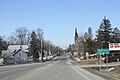
Pardeeville is a village in Columbia County, Wisconsin, United States. The population was 2,115 at the 2010 census. It is part of the Madison Metropolitan Statistical Area.

<span class="mw-page-title-main">Juneau, Wisconsin</span> City in Wisconsin, United States

Juneau is a city in Dodge County, Wisconsin, United States. The population was 2,658 at the 2020 census. It is the county seat of Dodge County.

<span class="mw-page-title-main">Beetown, Wisconsin</span> Town in Wisconsin, United States

The Town of Beetown is located in Grant County, Wisconsin, United States. The population was 734 at the 2000 census. The unincorporated communities of Beetown, Diamond Grove, Five Points, Flora Fountain, Hurricane, and North Andover are located in the town. The former community of Pleasant Ridge was also located in the town.

<span class="mw-page-title-main">Markesan, Wisconsin</span> City in Wisconsin, United States

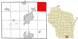
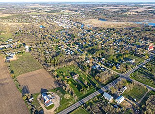
Markesan is a city in Green Lake County, Wisconsin, United States. The population was 1,476 at the 2010 census. The center of population of Wisconsin is located in Markesan.

<span class="mw-page-title-main">Schleswig, Wisconsin</span> Town in Wisconsin, United States

Schleswig is a town in Manitowoc County, Wisconsin, United States. The population was 1,900 at the 2000 census.

<span class="mw-page-title-main">Lima, Rock County, Wisconsin</span> Town in Rock County, Wisconsin, United States

The Town of Lima is located in Rock County, Wisconsin, United States. The population was 1,312 at the 2000 census. The unincorporated community of Lima Center is located in the town.

<span class="mw-page-title-main">Galesville, Wisconsin</span> City in Wisconsin, United States

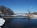
Galesville is a city in Trempealeau County, Wisconsin, United States. The population was 1,662 at the 2020 census. A dam on Beaver Creek is located at Galesville, forming Lake Marinuka north of the city. The mayor is Vince Howe.

<span class="mw-page-title-main">Union, Vernon County, Wisconsin</span> Town in Wisconsin, United States

Union is a town in Vernon County, Wisconsin, United States. The population was 531 at the 2000 census. The unincorporated community of White City is located in the town.

<span class="mw-page-title-main">Lake Geneva, Wisconsin</span> City in Wisconsin, United States

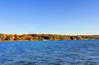
Lake Geneva is a city in the U.S. state of Wisconsin. Located in Walworth County and situated on Geneva Lake, it was home to 8,277 people as of the 2020 census, up from 7,651 at the 2010 census. It is about 40 miles southwest of Milwaukee and 65 miles northwest of Chicago.

<span class="mw-page-title-main">Clintonville, Wisconsin</span> City in Wisconsin, United States

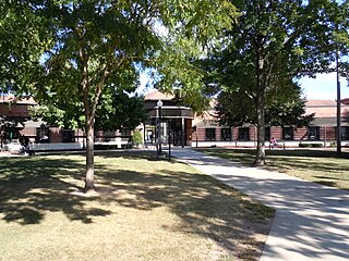
Clintonville is a city in Waupaca County, Wisconsin, United States. The population was 4,591 at the 2020 census. The area that became Clintonville was first settled in March, 1855.

<span class="mw-page-title-main">Newburg, Wisconsin</span> Village in Ozaukee and Washington counties, Wisconsin

Newburg is a village in Ozaukee and Washington counties in the U.S. state of Wisconsin. The population was 1,254 at the 2010 census. Of this, 1,157 were in Washington County, and only 97 were in Ozaukee County.

<span class="mw-page-title-main">Barron, Wisconsin</span> City in Wisconsin, United States

Barron is a city in Barron County, in the U.S. state of Wisconsin. The population was 3,733 at the 2020 census. The city is surrounded by the Town of Barron.

<span class="mw-page-title-main">Alma, Wisconsin</span> City in Wisconsin, United States

Alma is a city in and the county seat of Buffalo County, Wisconsin, United States. The population was 716 at the 2020 census.

<span class="mw-page-title-main">Wyocena, Wisconsin</span> Village in Wisconsin, United States

Wyocena is a village in Columbia County, Wisconsin, United States. The population was 768 at the 2010 census. The village is located within the Town of Wyocena. It is part of the Madison Metropolitan Statistical Area.

<span class="mw-page-title-main">Beaver Dam, Wisconsin</span> City in Wisconsin, United States

Beaver Dam is a city in Dodge County, Wisconsin, United States, along Beaver Dam Lake and the Beaver Dam River. The population was 16,708 at the 2020 census, making it the largest city primarily located in Dodge County. It is the principal city of the Beaver Dam Micropolitan Statistical area which is included in the larger Milwaukee–Waukesha–Racine CSA. The city is adjacent to the Town of Beaver Dam.

Oakfield is a town in Fond du Lac County, Wisconsin, United States. The population was 767 at the 2000 census. The Village of Oakfield is located within the town. The unincorporated community of Oak Center is also located in the town.

<span class="mw-page-title-main">Monroe, Wisconsin</span> City in Wisconsin, United States

Monroe, known as "the Cheese Capital of the USA", is a city in and the county seat of Green County, Wisconsin, United States. The population was 10,661 at the 2020 census. The city is bordered by the town of Monroe to the north and the town of Clarno to the south. Monroe is a part of the Madison Metropolitan Statistical Area

<span class="mw-page-title-main">Green Lake, Wisconsin</span> City in Wisconsin, United States

Green Lake is a city in and county seat of Green Lake County, Wisconsin, United States. The city had a population of 1,001 in the 2020 census. It is located on the north side of Green Lake. The Town of Green Lake is located on the south side of Big Green Lake, opposite the city.

<span class="mw-page-title-main">Princeton, Wisconsin</span> City in Wisconsin, United States

Princeton is a city in western part of Green Lake County, Wisconsin, United States. The population was 1,214 at the 2010 census. The city is located within the Town of Princeton. The Fox River flows through the city, dividing the city into an east half and west half.

<span class="mw-page-title-main">Waupaca, Wisconsin</span> City in Wisconsin, United States

Waupaca is a city in and the county seat of Waupaca County in the U.S. state of Wisconsin. The population was 6,282 at the 2020 census.

References

  1. "2019 U.S. Gazetteer Files". United States Census Bureau. Retrieved August 7, 2020.
  2. 1 2 "U.S. Census website". United States Census Bureau . Retrieved November 18, 2012.
  3. 1 2 "Population and Housing Unit Estimates". United States Census Bureau. May 24, 2020. Retrieved May 27, 2020.
  4. "Montello".
  5. "US Gazetteer files 2010". United States Census Bureau. Archived from the original on July 2, 2012. Retrieved November 18, 2012.
  6. 1 2 "NOAA Online Weather Data – NWS Milwaukee". National Weather Service. Retrieved October 6, 2023.
  7. "U.S. Climate Normals Quick Access – Station: Montello, WI". National Oceanic and Atmospheric Administration. Retrieved October 6, 2023.
  8. "Census of Population and Housing". Census.gov. Retrieved June 4, 2015.
  9. "U.S. Census website". United States Census Bureau . Retrieved January 31, 2008.
  10. "St. John's Evangelical Lutheran Church". Facebook .
  11. 'Proceedings of the State Bar Association of Wisconsin,' Wisconsin State Bar Association: 1905, Biographical Sketch of Edwin Bolivar Kelsey, pg 211-212