Guale

Last updated
Guale
Total population
Extinct as tribe
Regions with significant populations
Georgia/Sea Islands
Languages
Guale
Religion
Animist
Related ethnic groups
Mississippian culture; possibly ancestors of Muskogean peoples; Creek

Guale was a historic Native American chiefdom of Mississippian culture peoples located along the coast of present-day Georgia and the Sea Islands. Spanish Florida established its Roman Catholic missionary system in the chiefdom in the late 16th century.

Contents

During the late 17th century and early 18th century, Guale society was shattered by extensive epidemics of new infectious diseases and attacks by other tribes. Some of the surviving remnants migrated to the mission areas of Spanish Florida, while others remained near the Georgia coast. Joining with other survivors, they became known as the Yamasee, an ethnically mixed group that emerged in a process of ethnogenesis.

Language

Guale
RegionGeorgia
Extinct ca. 1700; perhaps became Yamasee
unclassified
Language codes
ISO 639-3 None (mis)
07u
Glottolog gual1239

Scholars have not reached a consensus on how to classify the Guale language. Early claims that the Guale spoke a Muskogean language were questioned by the historian William C. Sturtevant. He has shown that recorded vocabulary, which sources had believed to be Guale, was Creek, a distinct Muskogean language. [1]

Historical references note that the Jesuit Brother Domingo Agustín Váez recorded Guale grammar in 1569, but the documents have not been found. The Guale are believed to have been a Mississippian culture group that had a chiefdom along what is now the Georgia coast in the early period of Spanish exploration.

History

Prehistory

Archaeological studies indicate that the precursors of the historically known Guale lived along the Georgia coast and Sea Islands, from at least 1150 AD. Archaeologists identify the prehistoric Guale cultures as the Savannah phase (1150 to 1300 AD) and the Irene phase (1300 to circa 1600). While the prehistoric ancestors to the Guale shared many characteristics with regional neighbors, they left unique archaeological features that distinguished the "proto-Guale" people from other groups. [2]

The prehistoric people were organized into chiefdoms. They built Mississippian-type platform mounds, major earthworks requiring the organized labor of many people, and using highly skilled soil and engineering knowledge. They used the mounds for ceremonial, religious and burial purposes. [3]

European contact

Guale Indian greets early settler Guale Indian.jpg
Guale Indian greets early settler

French explorers under Jean Ribault contacted the Guale, whom they called the Oade after their chief, during their voyage to the Atlantic coast of North America in 1562. The Guale maintained good relations with the ephemeral French settlement known as Charlesfort on Parris Island in what is now South Carolina.

When the Spanish later established themselves in St. Augustine in Spanish Florida, they also contacted the Guale. They soon tried to bring them into their mission system. The Guale territory became one of the four primary mission provinces of Spanish Florida; the Timucua, Mocama, and Apalachee Provinces, also named after the resident tribes of the territories, were the others.

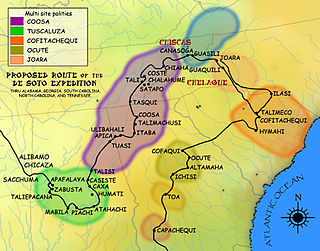
The boundaries of the Spanish Guale Province corresponded to the people's territory along the Atlantic coast and Sea Islands, north of the Altamaha River and south of the Savannah River. It included Ossabaw, St. Catherine's, Sapelo, Tybee, and Wassaw islands, among others. By the mid-17th century, the Spanish had established six Catholic missions in Guale territory, including Nuestra Señora de Guadalupe de Tolomato and Santa Catalina de Guale. Their largest settlements were probably on St. Catherine's Island.

Guale was the least stable of the four major mission provinces. The first Guale rebellion, often labeled Juanillo's Revolt, began on October 4, 1597. [4] The Guale rebelled again 1645, nearly shaking off the missions. They kept up a clandestine trade with French privateers, which provided them with alternate sources of goods. [5]

Effect on health

After the arrival of Europeans and their intervention in Guale villages, the Guale increased their consumption of corn. Bioarcheaologists tested the levels of C4 molecules in the natives' bones to determine the corn intake levels. By comparison, their intake of other foods such as fish, animals, other plants, etc. decreased. These changes were not for the better, as a corn-dominated diet is poor for overall health.  

The Guale Indians were forced to work under the Europeans in ways they never had had to before. It was labor-intensive. Spencer Larsen and Christopher Ruff concluded this based on their analysis of the second moments of area on humerus and femur bones. This is an engineering approach used to show the strength of the bone. They found that there was an increased strength of the bones due to higher repetitive usage, supporting the original statement. [6]

La Tama and Yamasee amalgamation

Indians throughout the American southeast were drawn to the Spanish mission provinces for their trade in European manufactured goods. Various non-Guale Indians settled in or near the Guale missions during the 17th century. Most were from an Indian province of north-central Georgia called La Tama by the Spanish. In the 1660s the well-armed Westo attacked La Tama and neighboring regions, dispersing the La Tama in several directions. Some migrated to the lower Chattahoochee River towns of Coweta and Cussita, the Apalachee mission provinces, and the Guale province. The La Tama spoke a dialect of Hitchiti, a Muskogean language, as did several towns in Apalachicola Province. The Guale language may or may not have been related. [7]

In 1675 the Spanish first used the term Yamasee to refer to the newcomer refugees. They thought them similar to the La Tama. In Guale Province, some of the Yamasee joined the existing missions, while others settled on the periphery.

Destruction and dispersal

Between 1675 and 1684, the Westo tribe, supported by English colonists in the colonies of Carolina and Virginia, destroyed all Spanish missions in Georgia. Attacks by English-supported pirates also contributed to the breakup of the missions. In 1680 a group of pirates sacked Mission Santa Catalina de Guale. By 1684 the Spanish and Indians had abandoned all six missions.

The La Tama Yamasee, Guale, and other refugees scattered in the southeast. Some relocated to new missions in Spanish Florida, but most rejected Spanish authority. They felt Spain had been unable to protect them and resented their failure to provide firearms. The Indians of Guale Province moved mostly to the Apalachee or Apalachicola regions. [8]

Emergence of the Yamasee

Around or before 1684, one small group of Yamasee-Guale refugees, led by Chief Altamaha, moved north to the mouth of the Savannah River. That year, a Scottish colony called Stuarts Town was founded in South Carolina on Port Royal Sound near the Savannah River. Stuarts Town survived only about two years, but during that time the Scots residents formed a strong bond with the Yamasee-Guale.

Yamasee Indian who was martyred in La Florida in 1740. Roberto Holy Card.jpg
Yamasee Indian who was martyred in La Florida in 1740.

In late 1684, armed with Scots firearms, these Indians raided Timucua Province, devastating the mission Santa Catalina de Afuyca. They returned to Stuarts Town with 22 captives, whom they sold as slaves. Over the next two years, word of similar successes of the Stuarts Town-allied Yamasee-Guale carried throughout the region. The population of "Yamasee" Indians near Port Royal Sound grew rapidly. Although the Indians became known collectively as "Yamasee", the Guale continued to be a significant portion of the population. [9]

Spanish forces destroyed Stuarts Town. In the old Guale Province, they strongly resisted counterattacks by South Carolina. Nonetheless, the alliance between the Yamasee and colonial South Carolina grew stronger in reaction. The "Yamasee" who migrated in 1685 to the Port Royal area were rebuilding the old La Tama chiefdom, but they also included numerous Guale, as well as other Indians of mostly Muskogean stock.

The Yamasee lived in South Carolina until they were defeated in the Yamasee War of 1715, after which survivors were widely dispersed and the people disintegrated as a polity. But while they lasted, the Yamasee exhibited multi-ethnic qualities. Their towns were described by European colonists as being Upper Yamasee or Lower Yamasee towns. The Lower Towns were populated mainly by La Tama Indians and included Altamaha (after the chief who lived there), Ocute, and Chechesee (Ichisi).

The Guale were the majority in the Upper Towns, although other ethnicities were incorporated as well. Upper Yamasee Towns with mostly Guale populations likely included Pocotaligo, Pocosabo, and Huspah. Other Upper Towns, such as Tulafina, Sadketche (Salkehatchie), and Tomatley, were probably mixed, with Guale, La Tama, and others. It is possible that the La Tama had spent time in missions and become somewhat Christianized. They may have sought out the similarly missionized Guale. [10]

In 1702, when Carolina Governor James Moore led an invasion into Spanish Florida, his men destroyed the few "refugee missions" in Guale. By 1733, the Guale were so few in number that they showed no resistance to James Oglethorpe's establishment of the Province of Georgia. [11]

A similar missionary province called Mocama (named for a Timucuan chiefdom) was situated just south of Guale, on the coast between the Altamaha River and St. Johns River in Florida.

See also

Notes

  1. Sturtevant, William C. (1994). "The Misconnection of Guale and Yamasee with Muskogean". International Journal of American Linguistics. 60 (2): 139–48. doi:10.1086/466226. JSTOR   1265616. S2CID   143736985.
  2. Saunders (2000), The Guale Indians of the Lower Atlantic Coast, p. 27
  3. Saunders (2000), The Guale Indians of the Lower Atlantic Coast, p. 30
  4. Spencer C. Tucker; James R. Arnold; Roberta Wiener (30 September 2011). The Encyclopedia of North American Indian Wars, 1607–1890: A Political, Social, and Military History. ABC-CLIO. p. 954. ISBN   978-1-85109-697-8 . Retrieved 13 April 2013.
  5. Oatis (2004), A Colonial Complex, p. 24
  6. Larsen, Clark Spencer (January 2005). "Reading the Bones of La Florida". Scientific American. 15 (1): 98–104. doi:10.1038/scientificamerican0105-98sp. ISSN   1048-0943.
  7. Oatis (2004), A Colonial Complex, p. 25
  8. Oatis (2004), A Colonial Complex, pp. 25–26
  9. Oatis (2004), A Colonial Complex, p. 27
  10. "The Foundation, Occupation, and Abandonment of Yamasee Indian Towns in the South Carolina Lowcountry, 1684–1715", National Register Multiple Property Submission, Dr. Chester B. DePratter.
  11. Floyd, Joseph (2013). "Ghosts of Guale: Sugar Houses, Spanish Missions, and the Struggle for Georgia's Colonial Heritage". Georgia Historical Quarterly. 97 (4): 387–410. Retrieved 14 February 2018.

Related Research Articles

<span class="mw-page-title-main">Muskogean languages</span> Language family of Southeast US

Muskogean is a Native American language family spoken in different areas of the Southeastern United States. Though the debate concerning their interrelationships is ongoing, the Muskogean languages are generally divided into two branches, Eastern Muskogean and Western Muskogean. Typologically, Muskogean languages are agglutinative. One documented language, Apalachee, is extinct and the remaining languages are critically endangered.

<span class="mw-page-title-main">Apalachee</span> Historical Native American tribe from Florida and Georgia, US

The Apalachee were an Indigenous people of the Southeastern Woodlands, specifically an Indigenous people of Florida, who lived in the Florida Panhandle until the early 18th century. They lived between the Aucilla River and Ochlockonee River, at the head of Apalachee Bay, an area known as the Apalachee Province. They spoke a Muskogean language called Apalachee, which is now extinct.

The Yamasee War was a conflict fought in South Carolina from 1715 to 1717 between British settlers from the Province of Carolina and the Yamasee, who were supported by a number of allied Native American peoples, including the Muscogee, Cherokee, Catawba, Apalachee, Apalachicola, Yuchi, Savannah River Shawnee, Congaree, Waxhaw, Pee Dee, Cape Fear, Cheraw, and others. Some of the Native American groups played a minor role, while others launched attacks throughout South Carolina in an attempt to destroy the colony.

The Yamasees were a multiethnic confederation of Native Americans who lived in the coastal region of present-day northern coastal Georgia near the Savannah River and later in northeastern Florida. The Yamasees engaged in revolts and wars with other native groups and Europeans living in North America, specifically from Florida to North Carolina.

Utinahica was a town that was the site of a Spanish mission, Santa Isabel de Utinahica. It may have been the chief town of a Timucua tribe and chiefdom in the 17th century, but Hann says there is not enough known about it to be sure. The name means "lord's village". Utinahica, was called a "province" in one Spanish report. It was 30 leagues east of Arapaha, and 50 leagues northeast of the town of Tarihica in the Northern Utina Province. It was at or near where the Oconee and Ocmulgee rivers join to form the Altamaha River. The people of Utinahica apparently practiced a regional variant of the Lamar regional culture, unusual for a Timucuan-speaking people. Worth identifies the province of Utinahica with archaeological sites, including the Lind Landing site, Coffee Bluff site, and Bloodroot site, that have yielded artifacts of the Square Ground Lamar culture from before the 15th century until the middle of the 17th century. The Square Ground Lamar culture is otherwise associated with sites occupied by speakers of Muskogean languages. Archaeological sites identified with all other known Timucuan-speakers, with the possible exception of Guadalquini, do not have affinities with the Square Ground Lamar culture.

<span class="mw-page-title-main">Apalachee Province</span> Area in present-day Florida

Apalachee Province was the area in the Panhandle of the present-day U.S. state of Florida inhabited by the Native American peoples known as the Apalachee at the time of European contact. The southernmost extent of the Mississippian culture, the Apalachee lived in what is now Leon County, Wakulla County and Jefferson County. The name was in use during the early period of European exploration. During Spanish colonization, the Apalachee Province became one of the four major provinces in the Spanish mission system, the others being the Timucua Province,, the Mocama Province and the Guale Province.

The Westo were an Iroquoian Native American tribe encountered in the Southeastern U.S. by Europeans in the 17th century. They probably spoke an Iroquoian language. The Spanish called these people Chichimeco, and Virginia colonists may have called the same people Richahecrian. Their first appearance in the historical record is as a powerful tribe in colonial Virginia who had migrated from the mountains into the region around present-day Richmond. Their population provided a force of 700–900 warriors.

<span class="mw-page-title-main">Mocama</span> Indigenous people of Florida and Georgia, US

The Mocama were a Native American people who lived in the coastal areas of what are now northern Florida and southeastern Georgia. A Timucua group, they spoke the dialect known as Mocama, the best-attested dialect of the Timucua language. Their heartland extended from about the Altamaha River in Georgia to south of the mouth of the St. John's River, covering the Sea Islands and the inland waterways, Intracoastal. and much of present-day Jacksonville. At the time of contact with Europeans, there were two major chiefdoms among the Mocama, the Saturiwa and the Tacatacuru, each of which evidently had authority over multiple villages. The Saturiwa controlled chiefdoms stretching to modern day St. Augustine, but the native peoples of these chiefdoms have been identified by Pareja as speaking Agua Salada, which may have been a distinct dialect.

<span class="mw-page-title-main">Apalachee massacre</span> 1704 raids by English colonists against Native Americans

The Apalachee massacre was a series of raids by English colonists from the Province of Carolina and their Indian allies against a largely peaceful population of Apalachee Indians in northern Spanish Florida that took place in 1704, during Queen Anne's War. Against limited Spanish and Indian resistance, a network of missions was destroyed; most of the population either was killed or captured, fled to larger Spanish and French outposts, or voluntarily joined the English.

<span class="mw-page-title-main">Spanish missions in Florida</span> Catholic religious outposts

Beginning in the second half of the 16th century, the Kingdom of Spain established a number of missions throughout La Florida in order to convert the Native Americans to Christianity, to facilitate control of the area, and to prevent its colonization by other countries, in particular, England and France. Spanish Florida originally included much of what is now the Southeastern United States, although Spain never exercised long-term effective control over more than the northern part of what is now the State of Florida from present-day St. Augustine to the area around Tallahassee, southeastern Georgia, and some coastal settlements, such as Pensacola, Florida. A few short-lived missions were established in other locations, including Mission Santa Elena in present-day South Carolina, around the Florida peninsula, and in the interior of Georgia and Alabama.

<span class="mw-page-title-main">Spanish missions in Georgia</span> Catholic religious outposts

The Spanish missions in Georgia comprised a series of religious outposts established by Spanish Catholics in order to spread the Christian doctrine among the Guale and various Timucua peoples in southeastern Georgia.

Port Royal Sound is a coastal sound, or inlet of the Atlantic Ocean, located in the Sea Islands region, in Beaufort County in the U.S. state of South Carolina. It is the estuary of several rivers, the largest of which is the Broad River.

<span class="mw-page-title-main">Fort King George</span> United States historic place

Fort King George State Historic Site is a fort located in the U.S. state of Georgia in McIntosh County, adjacent to Darien. The fort was built in 1721 along what is now known as the Darien River and served as the southernmost outpost of the British Empire in the Americas until 1727. The fort was constructed in what was then considered part of the colony of South Carolina, but was territory later settled as Georgia. It was part of a defensive line intended to encourage settlement along the colony's southern frontier, from the Savannah River to the Altamaha River. Great Britain, France, and Spain were competing to control the American Southeast, especially the Savannah-Altamaha River region.

Apalachicola was the name of a Native American tribal town, and of a group of towns associated with it, which the Spanish called Apalachicola Province, located along the lower part of the Chattahoochee River in present-day Alabama and Georgia. It is believed that before the 17th century, the residents of all the Apalachicola towns spoke the Hitchiti language, although other towns whose people spoke the Muscogee language relocated among the Apalachicolas along the Chattahoochee River in the middle- to later- 17th century. All of the Apalachicola towns moved to central Georgia at the end of the 17th century, where the English called them "Ochese Creek Indians". They moved back to the Chattahoochee River after 1715, with the English then calling them "Lower Creeks", while the Spanish called them "Ochese".

Henry Woodward, was a Barbados-born merchant and colonist who was one of the first white settlers in the Carolinas. He established relationships with many Native American Tribes in the American southeast. He initiated trade, primarily in deerskins and slaves, with many Indian towns and tribes.

Santa Catalina de Guale (1602-1702) was a Spanish Franciscan mission and town in Spanish Florida. Part of Spain's effort to convert the Native Americans to Catholicism, Santa Catalina served as the provincial headquarters of the Guale mission province. It also served various non-religious functions, such as providing food and labor for the colonial capital of St. Augustine. The mission was located on St. Catherines Island from 1602 to 1680, then on Sapelo Island from 1680 to 1684, and finally on Amelia Island from 1684 to 1702.

The indigenous peoples of Florida lived in what is now known as Florida for more than 12,000 years before the time of first contact with Europeans. However, the indigenous Floridians living east of the Apalachicola River had largely died out by the early 18th century. Some Apalachees migrated to Louisiana, where their descendants now live; some were taken to Cuba and Mexico by the Spanish in the 18th century, and a few may have been absorbed into the Seminole and Miccosukee tribes.

<span class="mw-page-title-main">Siege of St. Augustine (1702)</span> Part of Queen Annes War

The siege of St. Augustine occurred in Queen Anne's War during November and December 1702. It was conducted by English colonists from the Province of Carolina and their Indian allies, under the command of governor of Carolina James Moore, against the Spanish colonial fortress of Castillo de San Marcos at St. Augustine, in Spanish Florida.

San Buenaventura de Guadalquini or San Buenaventura de Boadalquivi was a Spanish mission located on St. Simon's Island, Georgia, United States from between 1597 and 1609 until 1684, when pirates burned the mission and its town. The mission moved to the north side of the St. Johns River near its mouth, in present day Duval County, Florida under the name of Santa Cruz de Guadalquini or Santa Cruz y San Buenaventura de Guadalquini for a few years before merging with the mission San Juan del Puerto.

<span class="mw-page-title-main">Ocute</span> Native American paramount chiefdom

Ocute, later known as Altamaha or La Tama and sometimes known conventionally as the Oconee province, was a Native American paramount chiefdom in the Piedmont region of the U.S. state of Georgia in the 16th and 17th centuries. Centered in the Oconee River valley, the main chiefdom of Ocute held sway over the nearby chiefdoms of Altamaha, Cofaqui, and possibly others.

References