
Cecil County is a county located in the U.S. state of Maryland at the northeastern corner of the state, bordering both Pennsylvania and Delaware. As of the 2020 census, the population was 103,725. The county seat is Elkton.
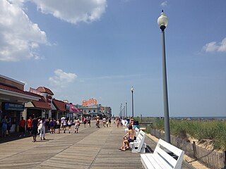
Rehoboth Beach is a city on the Atlantic Ocean along the Delaware Beaches in eastern Sussex County, Delaware. As of 2020, its population was 1,108. Along with the neighboring coastal town of Lewes, Rehoboth Beach is one of the principal cities of Delaware's rapidly growing Cape Region. Rehoboth Beach lies within the Salisbury metropolitan area.

South Bethany is an incorporated town in Sussex County, Delaware, United States. According to the 2010 census, the population of the town is 449, a decrease of 8.7% over the previous decade. It is part of the Salisbury, Maryland-Delaware Metropolitan Statistical Area.

Chesapeake City is a town in Cecil County, Maryland, United States. The population was 736 at the 2020 census.
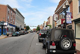
Elkton is a town in and the county seat of Cecil County, Maryland, United States. The population was 15,443 at the 2010 census. It was formerly called Head of Elk because it sits at the head of navigation on the Elk River, which flows into the nearby Chesapeake Bay. The town constitutes part of the Delaware Valley.

The Jersey Shore is the coastal region of the U.S. state of New Jersey. Geographically, the term encompasses about 141 miles (227 km) of oceanfront bordering the Atlantic Ocean, from Perth Amboy in the north to Cape May Point in the south. The region includes Middlesex, Monmouth, Ocean, Atlantic, and Cape May counties, which are in the central and southern parts of the state. Located in the center of the Northeast Megalopolis, the northern half of the shore region is part of the New York metropolitan area, while the southern half of the shore region is part of the Philadelphia metropolitan area, also known as the Delaware Valley. The Jersey Shore hosts the highest concentration of oceanside boardwalks in the United States.

The Eastern Shore of Maryland is a part of the U.S. state of Maryland that lies mostly on the east side of the Chesapeake Bay. Nine counties are normally included in the region. The Eastern Shore is part of the larger Delmarva Peninsula that Maryland shares with Delaware and Virginia.

Maryland Route 213 (MD 213) is a 68.25-mile (109.84 km) state highway located on the Eastern Shore of Maryland in the United States. The route runs from MD 662 in Wye Mills, Queen Anne's County, north to the Pennsylvania border in Cecil County, where the road continues into that state as Pennsylvania Route 841 (PA 841). The route, which is a two-lane undivided highway most of its length, passes through mainly rural areas as well as the towns of Centreville, Chestertown, Galena, Cecilton, Chesapeake City, and Elkton. MD 213 intersects many routes including U.S. Route 50 (US 50) near Wye Mills, US 301 near Centreville, and US 40 in Elkton. It crosses over the Chesapeake & Delaware Canal in Chesapeake City on the Chesapeake City Bridge. MD 213 is designated by the state as the Chesapeake Country Scenic Byway between the southern terminus and Chesapeake City with the portion north of MD 18 in Centreville a National Scenic Byway. In addition, the route is also considered part of the Atlantic to Appalachians Scenic Byway between Chesapeake City and MD 273 in Fair Hill.
The Sassafras River is a tributary of the Chesapeake Bay on the Delmarva Peninsula in the United States. It is approximately 22 miles (35 km) long and starts in western New Castle County, Delaware, and along the boundary between Cecil County, Maryland on the north and Kent County, Maryland on the south. It rises southwest of Middletown, Delaware and ends at the Chesapeake Bay in a wide mouth between Howell Point near Betterton, Maryland and Grove Point on Grove Neck.

The Bohemia River is a 4.7-mile-long (7.6 km) tributary of the Elk River on the Delmarva Peninsula. It is located in Cecil County, Maryland, with its headwaters extending into New Castle County, Delaware.

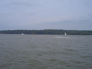
The Elk River is a tidal tributary of the Chesapeake Bay on the Eastern Shore of Maryland and on the northern edge of the Delmarva Peninsula. It is about 15 miles (24 km) long. As the most northeastern extension of the Chesapeake Bay estuary, it has served as one entrance to the Chesapeake & Delaware Canal since the 19th century. The canal and river now serve as one boundary of the Elk Neck Peninsula. The river flows through Cecil County, Maryland, with its watershed extending into New Castle County, Delaware and Chester County, Pennsylvania. Elkton, the county seat of Cecil County, is located at its head. Its total watershed area is 143 square miles (370 km2), with 21 square miles (54 km2) of open water, so its watershed is 15% open water. It is south and east of the North East River, and north of the Sassafras River.

Augustine Herman, First Lord of Bohemia Manor was a Bohemian explorer, merchant and cartographer who lived in New Amsterdam and Cecil County, Maryland. In the employment of Cecil Calvert, 2nd Baron Baltimore, he produced a remarkably accurate map of the Chesapeake Bay and Delaware Bay regions of North America, in exchange for which he was permitted to establish an enormous plantation that he named Bohemia Manor in what is now southeastern Cecil County, Maryland.

Broadkill Beach is an unincorporated beach community in Sussex County, in the U.S. state of Delaware, located on the Delaware Bay north of the mouth of the Broadkill River. It is part of the Salisbury, Maryland-Delaware Metropolitan Statistical Area. The word kill is from the Dutch word kil.

Fox Point State Park is a Delaware state park on 108 acres (44 ha) along the Delaware River in New Castle County, Delaware in the United States. The park, which opened in 1995, has been built atop a former hazardous waste site that has been rehabilitated under an adaptive reuse program that was spearheaded by S. Marston Fox and the Fox Point Civic Association. Fox Point State Park is open for year-round use from 8:00 am until sunset. The park offers recreational opportunities on biking and pedestrian trails with picnic facilities, a playground and volleyball and horseshoes facilities. Fox Point State Park is just off Interstate 495 and is the northern terminus of Delaware's Coastal Heritage Greenway.
The Cecil County Sheriff's Office (CCSO) is the primary law enforcement agency servicing a population of more than 100,000 people within Cecil County, Maryland's 348.13 square miles (901.7 km2). The CCSO was established in 1674 and is responsible for the protection of life and property, enforcing orders of the court, and maintaining the detention facility for Cecil County.

New Castle and Frenchtown Railroad Right-of-Way is a railroad right of way connecting Frenchtown, Cecil County, Maryland, and Porter, New Castle County, Delaware. The New Castle and Frenchtown Railroad originally crossed the Delmarva Peninsula from a wharf in New Castle to a wharf at Frenchtown on the Elk River in Maryland. This part of the right-of-way is abandoned for railroad purposes, although parts of it serve as county roads.
Frenchtown was a historic settlement on the Elk River in Cecil County, Maryland, United States.
Crystal Beach is an unincorporated community in Cecil County, Maryland, United States.
Childs is an unincorporated community in Cecil County Maryland, United States.


