I-35W & Lake Street station

Last updated
I-35W & Lake St
I-35W & Lake St station opening morning.jpg
I-35W & Lake St station entrance on opening morning
General information
Location190 East Lake Street
Minneapolis, Minnesota
Coordinates 44°56′54″N93°16′29″W / 44.94836°N 93.27473°W / 44.94836; -93.27473
Platforms2 side platforms
ConnectionsAiga bus trans.svg Metro Transit: 11, 18, 21
Construction
AccessibleYes
History
OpenedApril 15, 1968 (1968-04-15)
Rebuilt2021
Services
Preceding station Metro Minnesota icon.svg Metro Following station
Downtown Minneapolis Orange Line I-35W and 46th Street
Future services
Preceding station Metro Minnesota icon.svg Metro Following station
Lake & Nicollet B Line Lake & 4th/5th Avenue

I-35W & Lake Street station is a bus rapid transit station along the Metro Orange Line and planned B Line bus rapid transit (BRT) routes in Minneapolis, Minnesota. In addition to the BRT services, the station is also served by Metro route 578, Minnesota Valley Transit Authority routes 460, 465, 467, 470, 472, 475 and 477, along with SouthWest Transit routes 600 and 695.

Contents

The current station opened on October 21, 2021, replacing an inconvenient pair of on-highway bus stops along the outside lanes of I-35W at Lake Street. The station itself cost $20 million and was built as part of the 35W@94: Downtown to Crosstown reconstruction project. [1] The new two-story station is located between I-35W over Lake Street with a transit plaza on Lake Street with a landscaped ramp connecting it to the Midtown Greenway. [2] The old bus stops were not compliant with the Americans with Disabilities Act (ADA) since stairways were the only way pedestrians were able to access the freeway stops to and from Lake Street below. The new station will be ADA-compliant with four elevators (along with ramps and stairs) for a seamless transition between either side of the busway platforms and Lake Street platforms.

History

The original station opened April 15, 1968 following the completion of Interstate 35W between Crosstown (MN 62) and Interstate 94. [3] [4] Freeway service to the station was initially provided by Twin City Lines Route 35 Freeway Express and later Bloomington Bus Company, both providing suburban express bus service from Richfield and Bloomington to Downtown Minneapolis. [5] [6] The station connected with Twin City Lines frequent and heavily used Route 21 Selby-Lake along Lake Street and Selby Avenue between Uptown and Downtown Saint Paul. [7] The Metropolitan Transit Commission (MTC), now Metro Transit, acquired Twin City Lines in 1970 and Bloomington Bus Company in 1975. Under MTC, Route 21 remained similar to its present day operation, while all express bus service along I-35W from Downtown Minneapolis were formed under Route 35 [note 1] with several branches beginning at 35th Street. [8] In 1972 there were 14 branches of Route 35 using the station. [9]

By 1979 the station had transitioned from a simple transfer point to a transit hub. All-day and weekend Route 47 supplemented the rush-hour oriented Route 35 from Downtown Minneapolis to Richfield and Bloomington. The short-lived Route 49 was inaugurated as a shuttle bus between the station and Honeywell's recently completed corporate headquarters nearby at 28th Street. [10] [11] As transit service in the region expanded additional rush-hour buses began to use the station, including Route 94L express bus service along Lake Street to Downtown Saint Paul. After establishment in 1986 SouthWest Metro Transit, now SouthWest Transit, took over bus service in southwest suburbs and became the first operator to use the station other than MTC since 1975. Similarly in 1990 the Minnesota Valley Transit Authority (MVTA) took over bus service in the south suburbs and began utilizing the station. Following the completion of Interstate 394 in the early 1990s SouthWest Transit abandoned the station to take advantage of the reversible HOT lanes along I-394.

In 1997 Allina Health co-sponsored a study to improve access to their Abbott Northwestern Hospital campus from I-35W, considering additional freeway and transit access. [12] The study became known as the I-35W Access Project and concluded that a new Lake Street station would be constructed, in addition to bus lanes on both the freeway level and Lake Street. [13] Designs were completed November 2002 and recommended an island platform in the median of I-35W accessible from either side of Lake Street. Construction was anticipated to begin in late 2004. [14] After the opening of I-35W & 46th Street station, idea of a freeway island platform was changed to side platforms in the median of I-35W after considering safety and bus throughput concerns. [15]

In June 2004 Route 27 began operating to connect major employers (including Abbott Northwestern) along 26th and 28th Avenues between the station and the new Lake Street/Midtown station. [16] In 2010 the 2030 Transportation Policy Plan identified that the Orange Line (then known as the I-35W Bus Rapid Transit) would open by 2012, bypassing Lake Street until a new station was constructed. That plan was later shelved after unexpected congestion at I-35W and Crosstown Highway. After the opening of the I-35W & 46th Street station, it was observed that bus drivers had difficulty maneuvering from the HOT lanes in the center of the freeway, particularly during rush-hour traffic, to the side platforms of the old Lake Street station. In 2011 northbound express bus service was modified to the Lake Street stop, reducing it to only drop-off service during non-rush hour trips. [17]

The old station permanently closed June 9, 2018 to begin rebuilding in 2020, with a reopening date sometime between fall 2020 and winter 2021. [18] [19] During this time I-35W buses were detoured either via 1st and Blaisdell Avenues (Metro Transit routes) or Park and Portland Avenues (MVTA routes), with Metro Transit routes stopping at Lake Street upon request. [20] As freeway construction progressed, routes would be brought back to I-35W, bypassing Lake Street completely as the old station platforms were demolished. [18]

I-35W & Lake Street station from above I-35W & Lake Street station from above.jpg
I-35W & Lake Street station from above

The new station was planned to open on October 18, 2021 with a ceremony held at the station. [21] However, on October 16 around 7:40 p.m a driver traveling northbound on I-35W collided into the station, setting it on fire. The driver, Sean Patrick McClernon, died from multiple blunt force injuries from the collision. [22] The opening of the station needed to be postponed to undergo safety inspection after the crash, which caused minor damage to the southeast circulation tower. [23] [1] The station opened on October 21 without a ceremony. Upon opening, Southwest Transit returned to the station for the first time since the 1990s. MVTA returned November 20. [24]

Bus connections

Notes

  1. At this time, express bus routes operating along I-35E were also operated as Route 35, but were considered separate routes as Minneapolis and Saint Paul (with their respective suburbs) had route numbering independent from each other.

Related Research Articles

<span class="mw-page-title-main">Metro Blue Line (Minnesota)</span> Light rail line in Hennepin County, Minnesota

The Metro Blue Line is a 12-mile (19.3 km) light rail line in Hennepin County, Minnesota, that is part of the Metro network. It travels from downtown Minneapolis to Minneapolis–Saint Paul International Airport and the southern suburb of Bloomington. Formerly the Hiawatha Line prior to May 2013, the line was originally named after the Milwaukee Road's Hiawatha passenger train and Hiawatha Avenue, reusing infrastructure from the former and running parallel to the latter for a portion of the route. The line opened June 26, 2004, and was the first light rail service in Minnesota. An extension, Bottineau LRT, is planned to open in 2028.

Metro Transit is the primary public transportation operator in the Minneapolis–Saint Paul area of the U.S. state of Minnesota and the largest operator in the state. Although Metro Transit is one of the smallest transit systems for a large metropolitan area in the United States, it has previously been ranked as one of the best. In 2023, the system had a ridership of 44,977,200, or about 145,600 per weekday as of the fourth quarter of 2023.

<span class="mw-page-title-main">Government Plaza station</span> Light rail station in Minneapolis, Minnesota

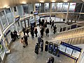
Government Plaza station is a Metro light rail station on the Blue Line and Green Line in Minneapolis, Minnesota. The station is located on 5th Street South, between 3rd and 4th Avenues South in downtown Minneapolis. This station opened on June 26, 2004, with initial light rail service in the Twin Cities.

<span class="mw-page-title-main">Interstate 35W (Minnesota)</span> Interstate Highway in Minnesota, United States

Interstate 35W (I-35W) is an Interstate Highway in the US state of Minnesota, passing through downtown Minneapolis. It is one of two through routes for I-35 through the Twin Cities of Minneapolis and Saint Paul, the other being I-35E through downtown Saint Paul.

<span class="mw-page-title-main">Minnesota Valley Transit Authority</span> Public transportation agency in Minnesota, US

The Minnesota Valley Transit Authority, also known by the acronym MVTA, is a public transportation agency that serves seven communities in the southern portion of the Minneapolis–Saint Paul metropolitan area. The agency provides fixed-route and demand-responsive transit within the service area of the communities and to select destinations in the region.

<span class="mw-page-title-main">Metro Red Line (Minnesota)</span>

The Metro Red Line is a bus rapid transit line between the Twin Cities suburbs of Bloomington, Minnesota and Apple Valley, Minnesota. The Red Line travels primarily on Minnesota State Highway 77 and Cedar Avenue from the Apple Valley station in Apple Valley, north through Eagan, Minnesota, to the Mall of America station in Bloomington where it connects to the Metro Blue Line. The line has bus rapid transit elements including bus-only lanes, specially branded vehicles, transit signal priority, and dedicated stations.

<span class="mw-page-title-main">Burnsville Transit Station</span> Transit facility in Burnsville, Minnesota

Burnsville Transit Station is a transit facility located in the vicinity of downtown Burnsville, Minnesota, and is the flagship station of the Minnesota Valley Transit Authority (MVTA). The station is the busiest park and ride location in the Twin Cities region and offers approximately 1,400 parking spaces. It is also a major transfer hub for routes operating the south of the Minnesota River. The station has indoor climate-controlled waiting, restrooms, lost and found, drinking fountains, vending machines, Go-To card sales, newspaper racks, and transit information. Due to high park and ride demand, MVTA moved some service to the 370 space Heart of the City public ramp about a 12 mile (0.80 km) south in 2018. The Metropolitan Council's 2021 park-and-ride system report found 267 cars parked at the station compared to 1,116 in 2019 before the COVID-19 pandemic.

<span class="mw-page-title-main">Metro Orange Line (Minnesota)</span> Minnesota bus line

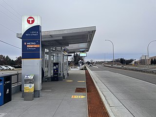
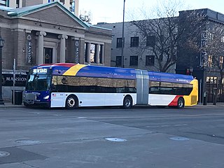
The Metro Orange Line is a bus rapid transit line in the Twin Cities, Minnesota operated by Metro Transit. The line operates primarily along Interstate 35W from downtown Minneapolis through Richfield and Bloomington before terminating in Burnsville, Minnesota. The Orange Line provides access to 198,000 jobs with roughly a quarter of them outside downtown Minneapolis. The route serves a mix of stations located in the center of the highway, stations near highway exits, and on-street stations. The line has features typical of bus rapid transit systems with off-board fare payment, articulated buses with extra doors, stations with improved passenger amenities, and transit-only bus lanes on portions of the route.

<span class="mw-page-title-main">Apple Valley station</span> Transit facility in the United States

The Apple Valley Transit Station is a transit facility located in Apple Valley, Minnesota. It is owned by the City of Apple Valley and the MVTA. The transit station is near Cedar Avenue and Gaslight Drive. This station has 337 parking spaces and is almost full almost each weekday. It also serves the nearby communities of Lakeville and Farmington.

<span class="mw-page-title-main">Eagan Transit Station</span>

The Eagan Transit Station is a transit facility located in Eagan, Minnesota. Riders also hail from the nearby communities of Mendota Heights and Northern Rosemount. The Park & Ride lot has 750 parking spaces for bus passengers and retail employees.

<span class="mw-page-title-main">Cedar Grove Transit Station</span>

The Cedar Grove Transit Station is a transit facility in Eagan, Minnesota. It serves the Minnesota Valley Transit Authority bus system and the Metro Red Line bus rapid transit system. It opened March 20, 2010, in the Cedar Grove community.

<span class="mw-page-title-main">Kenrick Avenue Park and Ride station</span> Parking facility in Lakeville, Minnesota

The Kenrick Avenue Park and Ride is a 750-space parking ramp in Lakeville, Minnesota providing interchange for bus passengers.

<span class="mw-page-title-main">I-35W & 46th Street station</span> Bus rapid transit station in Minneapolis on the Orange Line

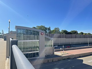
I-35W & 46th Street station is a Metro Orange Line bus rapid transit station located in Minneapolis, Minnesota. In addition to the BRT service, the station is also served by Metro route 578. The station was constructed as part of the I-35W/Minnesota State Highway 62 Crosstown Commons reconstruction project and opened in 2010. Consisting of two levels, one on East 46th Street, and the other in the median of Interstate 35W, the station was the first of its kind in Minnesota. The station allows for transit routes operating on I-35W to stop for riders without leaving the region's high occupancy toll lane system. The station was designed in anticipation of full bus rapid transit service along I-35W to downtown Minneapolis, a vision that was realized in 2021 with the opening of the Metro Orange Line. The station cost $4.5 million to build.

<span class="mw-page-title-main">I-35W & 98th Street station</span> Bus station in Bloomington, Minnesota

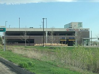
I-35W & 98th Street is a bus rapid transit station on the Metro Orange Line at 98th Street adjacent to Interstate 35W in Bloomington, Minnesota. The station is integrated with the South Bloomington Transit Center, a transfer hub and park and ride facility opened in 2004. The transit center was as far south as Route 535, predecessor to the Orange Line, traveled, with no direct connection to the other side of the Minnesota River. The station opened December 4, 2021 with the rest of the Orange Line.

<span class="mw-page-title-main">Metro (Minnesota)</span> Rapid transit network in the Minneapolis metropolitan area of the United States

Metro is a transit network in Minnesota serving the cities of Minneapolis and Saint Paul. It also provides service to some suburban areas. As of 2022, the system consists of two light rail lines and five bus rapid transit (BRT) lines all of which are operated by the local public transit company: Metro Transit. The five lines connect Downtown Minneapolis and St Paul with the Bloomington, Minneapolis-St Paul International Airport, Roseville, Richfield, Burnsville and Brooklyn Center.

<span class="mw-page-title-main">Metro C Line (Minnesota)</span> Bus rapid transit line in the Minneapolis metropolitan area of the United States

The Metro C Line is a bus rapid transit line in Brooklyn Center and Minneapolis, Minnesota operated by Metro Transit. The line is part of Metro Transit's Metro network of light rail and bus rapid transit lines. The route operates from the Brooklyn Center Transit Center along Penn Avenue and Olson Memorial Highway, terminating in downtown Minneapolis. The route is analogous to the existing Route 19 and is projected to increase ridership on this corridor from 7,000 to 9,000 by 2030. Eventually, part of its route will shift south to Glenwood Avenue from Olson Memorial Highway.

<span class="mw-page-title-main">Metro B Line (Minnesota)</span> Planned bus rapid transit line in the Minneapolis metropolitan area of the United States

The Metro B Line is an under construction bus rapid transit route in Minneapolis and St. Paul. The route will operate mostly on Lake Street in Minneapolis before crossing the Mississippi River into St. Paul and operating mostly on Selby Avenue and ending in downtown St. Paul. The route was identified in Metro Transit's 2014 Arterial Transitway Corridors Study as one of eleven local routes to be upgraded to bus rapid transit. The route will have "train-like" features to speed up service, such as signal priority, all-door boarding, further stop spacing, and specialized vehicles. Planning and design was completed in 2021, with construction beginning in May 2023. The line will join a number of Metro Transit's future Metro system lines, as well as the currently operating A Line, C Line, and D Line. Full funding for the line was secured in October 2020 with a final $35 million from the state of Minnesota.

<span class="mw-page-title-main">Metro E Line (Minnesota)</span> Bus rapid transit line in the Minneapolis metropolitan area of the United States

The Metro E Line is a planned bus rapid transit route in Minneapolis, Saint Paul, and Edina. The route will operate from Southdale Center Transit Center in Edina, Minnesota to Westgate station in Saint Paul. Running mostly on France Avenue, Hennepin Avenue, and University Avenue, the line will serve major destinations such as Southdale Center, Fairview Hospital, 50th & France, Linden Hills, Uptown, Minneapolis Sculpture Garden, Downtown Minneapolis, Dinkytown, the University of Minnesota, and Prospect Park. The route will have "train-like" features to speed up service and improve reliability, such as signal priority, bus lanes, all-door boarding, further stop spacing, and specialized vehicles. In 2019 planning and design were underway, with construction slated for 2023 and operations beginning a year later but that timeline has been moved back. The E Line would largely replace Route 6 which carries 9,000 trips each weekday. The project was fully funded with $60 million by the state of Minnesota in 2021 and is expected to open in 2025.

<span class="mw-page-title-main">Ramp A/7th Street Transit Center</span>

Ramp A/7th Street Transit Center is a bus rapid transit station in downtown Minneapolis, Minnesota. The transit center is a southbound station on the Metro C Line and D Line, as well as several local routes. The transit center is located inside of Ramp A, a 3,637 stall parking ramp built over sunken Interstate 394.

<span class="mw-page-title-main">Marq2 transit corridor</span> Public transit corridor through Minneapolis, Minnesota

The Marq2 transit corridor is a north–south thoroughfare in Minneapolis, Minnesota, United States. It consists of the parallel streets of Marquette and Second avenues in the downtown area. Each public streetway has two contraflow bus lanes with two lanes available for general-purpose traffic in the opposite direction. Vehicular transit flows south on Marquette Avenue and north on Second Avenue. The inner curb lane allows buses to stop for riders, while the second bus-only lane allows buses to pass each other along the corridor. Bus routes that operate on the corridor stop at every other block at an assigned gate with each route assigned a northbound and southbound gate. Gates are assigned letters A, B, C, or D on Marquette Avenue and E, F, G, and H on Second Avenue. Custom bus shelters are installed at each stop with heaters and real time transit information. The corridor primarily serves express buses operated by all five public transit agencies in the Twin Cities.

References

  1. 1 2 Murphy, Esme (18 October 2021). "Minneapolis' I-35W & Lake Street Station's Opening Delayed After Deadly Crash". WCCO. Retrieved 22 October 2021.
  2. Aaron Rupar. "Plans for Lake St. transit station proceeding slowly but steadily". Southwest Journal. Retrieved March 21, 2012.
  3. "Bloomington-Downtown Express Buses to Start Monday". The Minneapolis Tribune. April 10, 1968. p. 23. Retrieved 1 November 2021 via Newspapers.com.
  4. "Interstate 35W Minnesota". Interstate-Guide.com. Retrieved 22 October 2021.
  5. Vandervoort, Bill. "Suburban Transit Companies". www.chicagorailfan.com. Retrieved 22 October 2021.
  6. "Rider's Almanac Blog". www.metrotransit.org. Metro Transit. 13 October 2013. Retrieved 22 October 2021.
  7. Twin Cities Metropolitan Area (Central Study Portion) Bus Service (Map). Twin Cities Metropolitan Planning Commission. December 1966. OCLC   320188665.
  8. Twin Cities Metropolitan Area Bus Routes (Map). Metropolitan Transit Commission. 1975. OCLC   37336229.
  9. Wascoe Jr., Dan (December 12, 1972). "New express buses plentiful, but riders few". The Minneapolis Tribune. p.  A1, 4A . Retrieved 1 November 2021 via Newspapers.com.
  10. Martin, Frank Edgerton (29 June 2018). "Two little-known plazas in Minneapolis are examples of great urban design". Star Tribune. Retrieved 22 October 2021.
  11. Twin Cities Transit Guide (Map). Metropolitan Transit Commission. July 1979. OCLC   428732067.
  12. "History of the I-35W Access Project". Phillips Partnership. Retrieved 1 November 2021.
  13. "I-35W Access Project Summary" (PDF). Retrieved 1 November 2021.
  14. Russell, Scott (18 November 2002). "What is the I-35W Access Project?". Southwest Journal. Retrieved 1 November 2021.
  15. Bauman, Alex (3 May 2012). "Access to the Region's Chinese/Hibachi buffet". Getting Around Minneapolis. Retrieved 1 November 2021.
  16. "Rider's Almanac Blog". www.metrotransit.org. 10 January 2014.
  17. "Lake Street Station at I-35W: 2017 CMAQ Application" . Retrieved 1 November 2021.
  18. 1 2 "I-35W construction – Ride it out with us!". Metro Transit. Archived from the original on 24 June 2018. Retrieved 24 June 2018.
  19. I-35W Orange Line Lake Street Station Info
  20. Planned Metro Transit Detours for I-35W Construction Phasing (PDF) (Map). Metro Transit. Archived from the original (PDF) on 1 November 2021.
  21. Komarek, John (13 October 2021). "I-35W & Lake Street Station opening October 18". www.metrotransit.org. Metro Transit. Retrieved 1 November 2021.
  22. Kian, Ava (23 October 2021). "White Bear Lake man identified as driver in Lake Street I-35W bus station crash". Twin Cities Pioneer Press. Retrieved 1 November 2021.
  23. "I-35W bus station grand opening delayed due to fatal weekend crash". KSTP. 18 October 2021. Retrieved 1 November 2021.
  24. "I-35W & Lake Street Station". www.metrotransit.org. Retrieved 1 November 2021.