National Register of Historic Places listings in Queen Anne's County, Maryland

Last updated

Location of Queen Anne's County in Maryland Map of Maryland highlighting Queen Anne's County.svg
Location of Queen Anne's County in Maryland

This is a list of the National Register of Historic Places listings in Queen Anne's County, Maryland.

Contents

This is intended to be a complete list of the properties and districts on the National Register of Historic Places in Queen Anne's County, Maryland, United States. Latitude and longitude coordinates are provided for many National Register properties and districts; these locations may be seen together in a map. [1]

There are 40 properties and districts listed on the National Register in the county.

Contents: Counties in Maryland
Allegany - Anne Arundel - Baltimore (city) - Baltimore County - Calvert - Caroline - Carroll - Cecil - Charles - Dorchester - Frederick - Garrett - Harford - Howard - Kent - Montgomery - Prince George's - Queen Anne's - Somerset - St. Mary's - Talbot - Washington - Wicomico - Worcester


    This National Park Service list is complete through NPS recent listings posted March 1, 2024. [2]

Current listings

[3] Name on the RegisterImageDate listed [4] Location City or townDescription
1 Bachelor's Hope
Bachelor's Hope BACHELOR'S HOPE, CENTREVILLE, QUEEN ANNE'S COUNTY. MD.jpg
Bachelor's Hope
May 3, 1984
(#84001855)
Maryland Route 18
39°02′01″N76°06′18″W / 39.033611°N 76.105°W / 39.033611; -76.105 (Bachelor's Hope)
Centreville
2 Bishopton
Bishopton BISHOPTON, CHURCH HILL, QUEEN ANNE'S COUNTY, MD.jpg
Bishopton
September 12, 1985
(#85002194)
Pinder Hill Rd.
39°09′35″N75°58′26″W / 39.159722°N 75.973889°W / 39.159722; -75.973889 (Bishopton)
Church Hill
3 Bloomingdale
Bloomingdale BLOOMINGDALE, QUEENSTOWN, QUEEN ANNE COUNTY, MD.jpg
Bloomingdale
October 18, 1972
(#72001457)
Bloomingdale Rd. and U.S. Route 50
38°58′21″N76°07′01″W / 38.9725°N 76.116944°W / 38.9725; -76.116944 (Bloomingdale)
Queenstown
4 Bowlingly
Bowlingly Bowlinglyold.jpg
Bowlingly
August 21, 1972
(#72001458)
Off Maryland Route 18
38°59′36″N76°09′30″W / 38.993333°N 76.158333°W / 38.993333; -76.158333 (Bowlingly)
Queenstown
5 Captain's Houses
Captain's Houses Captain's Houses, Centreville, Maryland.jpg
Captain's Houses
November 17, 1980
(#80001830)
Corsica St.
39°03′07″N76°04′32″W / 39.051944°N 76.075556°W / 39.051944; -76.075556 (Captain's Houses)
Centreville
6 Centreville Armory
Centreville Armory Centreville Armory, Centreville, Maryland.jpg
Centreville Armory
September 25, 1985
(#85002666)
S. Commerce St.
39°02′30″N76°04′05″W / 39.041667°N 76.068056°W / 39.041667; -76.068056 (Centreville Armory)
Centreville
7 Centreville Historic District
Centreville Historic District CentrevilleCourthouse MD.jpg
Centreville Historic District
November 13, 2004
(#04001218)
Roughly bounded by the Corsica River, Chesterfield Ave, Liberty St, Banjo Ln, Railroad Ave, town limits, and Mill Stream
39°02′45″N76°04′02″W / 39.045833°N 76.067222°W / 39.045833; -76.067222 (Centreville Historic District)
Centreville
8 Chester Hall
Chester Hall CHESTER HALL, CHESTERTOWN, QUEEN ANNE'S COUNTY, MD.jpg
Chester Hall
January 18, 1980
(#80001831)
1 mile southeast of Chestertown on Maryland Route 213
39°12′17″N76°02′43″W / 39.204722°N 76.045278°W / 39.204722; -76.045278 (Chester Hall)
Chestertown
9 Christ Church
Christ Church Christ Church, Stevensville, Maryland.jpg
Christ Church
July 24, 1979
(#79003268)
Maryland Route 18
38°58′50″N76°18′52″W / 38.980556°N 76.314444°W / 38.980556; -76.314444 (Christ Church)
Stevensville
10 Churchill Theatre-Community Building
Churchill Theatre-Community Building ChurchHillTheatreLRWalls.jpg
Churchill Theatre-Community Building
September 8, 2000
(#00001051)
Maryland Route 19
39°08′31″N75°59′06″W / 39.141944°N 75.985°W / 39.141944; -75.985 (Churchill Theatre-Community Building)
Church Hill
11 Jackson Collins House
Jackson Collins House Jackson Collins House, Centreville, Maryland.jpg
Jackson Collins House
December 13, 2000
(#00001503)
201 S. Commerce St.
39°02′34″N76°03′58″W / 39.04285°N 76.06609°W / 39.04285; -76.06609 (Jackson Collins House)
Centreville
12 Content
Content Content1LRWalls.jpg
Content
February 13, 1986
(#86000256)
Maryland Route 305 near Tanyard Rd.
39°02′30″N76°01′17″W / 39.041667°N 76.021389°W / 39.041667; -76.021389 (Content)
Centreville
13 Cray House
Cray House Stevensville, Maryland (08-2007) 18.jpg
Cray House
May 9, 1983
(#83002960)
Cockey's Lane
38°58′53″N76°18′56″W / 38.981389°N 76.315556°W / 38.981389; -76.315556 (Cray House)
Stevensville
14 Delaware Boundary Markers February 18, 1975
(#75002101)
Boundary line dividing Delaware from Maryland and Pennsylvania
Coordinates missing
MultipleExtends into Delaware and southeastern Pennsylvania.
15 Dudley's Chapel
Dudley's Chapel DudleysChapelLRWalls.jpg
Dudley's Chapel
November 15, 1979
(#79003124)
Southwest of Sudlersville off Maryland Route 300
39°10′56″N75°53′33″W / 39.182222°N 75.8925°W / 39.182222; -75.8925 (Dudley's Chapel)
Sudlersville
16 John Embert Farm
John Embert Farm JOHN EMBERT FARM, MILLINGTON, QUEEN ANNE'S COUNTY. MD.jpg
John Embert Farm
June 22, 1980
(#80001832)
Southeast of Millington on Baxter Rd., 0.6 miles east of Peters Comer Rd.
39°13′30″N75°48′40″W / 39.225°N 75.811111°W / 39.225; -75.811111 (John Embert Farm)
Millington
17 Female Seminary
Female Seminary Female Seminary, Centreville, Maryland.jpg
Female Seminary
December 10, 2003
(#03001266)
205-207 S. Commerce St.
39°02′32″N76°03′59″W / 39.04234°N 76.06639°W / 39.04234; -76.06639 (Female Seminary)
Centreville
18 Friendship
Friendship FRIENDSHIP, STEVENSVILLE, QUEEN ANNE'S COUNTY; MD.jpg
Friendship
July 15, 1994
(#94000727)
200 Friendship Manor Dr.
38°57′12″N76°20′43″W / 38.953333°N 76.345278°W / 38.953333; -76.345278 (Friendship)
Stevensville
19 Hawkins Pharsalia
Hawkins Pharsalia HAWKINS PHARSALIA, RUTHSBURG, QUEEN ANNE COUNTY, MD.jpg
Hawkins Pharsalia
December 20, 1984
(#84000458)
Maryland Route 304
39°01′02″N75°55′06″W / 39.017222°N 75.918333°W / 39.017222; -75.918333 (Hawkins Pharsalia)
Ruthsburg
20 Keating House
Keating House Keating House, Centreville, Maryland.jpg
Keating House
October 28, 1999
(#99001281)
208 S. Liberty St.
39°02′35″N76°04′05″W / 39.04298°N 76.06796°W / 39.04298; -76.06796 (Keating House)
Centreville
21 Kennersley
Kennersley KENNERSLEY, CHURCH HILL, QUEEN ANNE'S COUNTY, MD.jpg
Kennersley
May 19, 1983
(#83002961)
Clabber Hill Rd.
39°08′46″N76°01′58″W / 39.146111°N 76.032778°W / 39.146111; -76.032778 (Kennersley)
Church Hill
22 Lansdowne
Lansdowne LANSDOWNE, CENTREVILLE, QUEEN ANNES COUNTY, MD.jpg
Lansdowne
June 7, 1984
(#84001858)
Maryland Route 305
39°02′49″N75°59′26″W / 39.046944°N 75.990556°W / 39.046944; -75.990556 (Lansdowne)
Centreville
23 Legg's Dependence
Legg's Dependence LEGG'S DEPENDENCE, QUEEN ANNE'S COUNTY, MD.jpg
Legg's Dependence
November 8, 2003
(#03001116)
0200 Long Creek Court
38°55′13″N76°20′46″W / 38.920278°N 76.346111°W / 38.920278; -76.346111 (Legg's Dependence)
Stevensville
24 Lexon
Lexon LEXON, CENTREVILLE, QUEEN ANNE COUNTY, MD.jpg
Lexon
May 4, 1990
(#90000726)
Corsica Neck Rd. southwest of Earle Cove
39°03′16″N76°05′15″W / 39.054444°N 76.0875°W / 39.054444; -76.0875 (Lexon)
Centreville
25 Mattapax
Mattapax MATTAPAX, QUEEN ANNE'S COUNTY, MD.jpg
Mattapax
December 10, 1998
(#98001498)
106 Shipping Creek Rd.
38°54′40″N76°20′54″W / 38.911111°N 76.348333°W / 38.911111; -76.348333 (Mattapax)
Stevensville
26 MYSTERY (log canoe) September 18, 1985
(#85002250)
Round Top Rd.
39°12′29″N76°02′16″W / 39.208056°N 76.037778°W / 39.208056; -76.037778 (MYSTERY (log canoe))
Kingstown
27 Capt. John H. Ozmon Store
Capt. John H. Ozmon Store CAPT.JOHN H. OZMON STORE, CENTREVILLE, QUEEN ANNES COUNTY, MD.jpg
Capt. John H. Ozmon Store
February 14, 1985
(#85000277)
Centreville Wharf
39°03′12″N76°04′28″W / 39.053333°N 76.074444°W / 39.053333; -76.074444 (Capt. John H. Ozmon Store)
Centreville
28 Readbourne
Readbourne Readbourne.jpg
Readbourne
April 11, 1973
(#73002134)
5.4 miles northwest of Centreville
39°07′38″N76°05′26″W / 39.127222°N 76.090556°W / 39.127222; -76.090556 (Readbourne)
Centreville
29 Reed's Creek Farm
Reed's Creek Farm REED'S CREEK FARM, CENTREVILLE, QUEEN ANNE COUNTY MD.jpg
Reed's Creek Farm
July 7, 1975
(#75002106)
West of Centreville on Wright's Neck Rd. off Maryland Route 18
39°03′05″N76°09′12″W / 39.051389°N 76.153333°W / 39.051389; -76.153333 (Reed's Creek Farm)
Centreville
30 St. Andrew's Episcopal Chapel
St. Andrew's Episcopal Chapel ST. ANDREW'S EPISCOPAL CHAPEL, SUDLERSVILLE, QUEEN ANNE COUNTY, MD.jpg
St. Andrew's Episcopal Chapel
September 7, 1984
(#84001853)
Church St. and Maple Ave.
39°11′06″N75°51′30″W / 39.185°N 75.858333°W / 39.185; -75.858333 (St. Andrew's Episcopal Chapel)
Sudlersville
31 St. Luke's Church
St. Luke's Church St.LukesLRWalls.jpg
St. Luke's Church
November 23, 1977
(#77001505)
Junction of Maryland Routes 19 and 213
39°08′32″N75°59′11″W / 39.142222°N 75.986389°W / 39.142222; -75.986389 (St. Luke's Church)
Church Hill
32 St. Peter's Church
St. Peter's Church St. Peteer's Church, Queenstown, Maryland.jpg
St. Peter's Church
March 10, 1980
(#80001833)
Southeast of Queenstown on U.S. Route 50
38°58′41″N76°08′03″W / 38.978056°N 76.134167°W / 38.978056; -76.134167 (St. Peter's Church)
Queenstown
33 Starr Church March 1, 2024
(#100009979)
1504 Starr Road
38°58′31″N76°00′26″W / 38.9754°N 76.00734°W / 38.9754; -76.00734 (Starr Church)
Centreville
34 Stevensville Bank
Stevensville Bank Stevensville Bank.jpg
Stevensville Bank
January 3, 1985
(#85000020)
Love Point Rd.
38°58′55″N76°18′53″W / 38.981944°N 76.314722°W / 38.981944; -76.314722 (Stevensville Bank)
Stevensville
35 Stevensville Historic District
Stevensville Historic District Stevensville, Maryland (08-2007) 14.jpg
Stevensville Historic District
September 11, 1986
(#86002333)
Maryland Route 18 and Love Point Rd.
38°58′53″N76°18′49″W / 38.981389°N 76.313611°W / 38.981389; -76.313611 (Stevensville Historic District)
Stevensville
36 Stratton
Stratton STRATTON, CENTREVILLE (RUTHSBURG) QUEEN ANNES COUNTY, MD.jpg
Stratton
December 18, 2003
(#03001294)
3102 Ruthsburg Rd.
39°01′41″N75°53′51″W / 39.028056°N 75.8975°W / 39.028056; -75.8975 (Stratton)
Centreville
37 Thomas House
Thomas House Thomas House, Ruthsburg.jpg
Thomas House
May 13, 1976
(#76002150)
1.8 miles northeast of Ruthsburg on Maryland Route 304
39°00′54″N75°55′53″W / 39.015°N 75.931389°W / 39.015; -75.931389 (Thomas House)
Ruthsburg
38 Wilton
Wilton LRoyWalls - Wilton - West Facing.jpg
Wilton
December 12, 1977
(#77001506)
North of Wye Mills on Maryland Route 213
38°56′58″N76°04′37″W / 38.949444°N 76.076944°W / 38.949444; -76.076944 (Wilton)
Wye Mills
39 Wye Hall
Wye Hall WYE HALL, QUEENSTOWN, QUEEN ANNE'S COUNTY. MD.jpg
Wye Hall
November 2, 2015
(#15000759)
505 Wye Hall Dr.
38°53′20″N76°07′07″W / 38.8888°N 76.1187°W / 38.8888; -76.1187 (Wye Hall)
Queenstown
40 Wye Mill
Wye Mill WyeMillLRWalls.jpg
Wye Mill
April 9, 1985
(#85000717)
Maryland Route 662
38°56′29″N76°04′53″W / 38.941389°N 76.081389°W / 38.941389; -76.081389 (Wye Mill)
Wye Mills Extends into Talbot County

See also

Related Research Articles

<span class="mw-page-title-main">National Register of Historic Places listings in Montgomery County, Maryland</span>

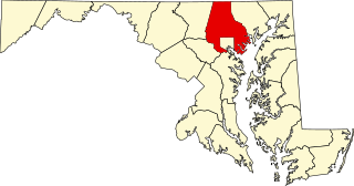
This is a list of the National Register of Historic Places listings in Montgomery County, Maryland.

<span class="mw-page-title-main">National Register of Historic Places listings in Anne Arundel County, Maryland</span>

This is a list of the National Register of Historic Places listings in Anne Arundel County, Maryland.

<span class="mw-page-title-main">National Register of Historic Places listings in Baltimore County, Maryland</span>

This is a list of the National Register of Historic Places listings in Baltimore County, Maryland.

<span class="mw-page-title-main">National Register of Historic Places listings in Carroll County, Maryland</span>

This is a list of the National Register of Historic Places listings in Carroll County, Maryland.

<span class="mw-page-title-main">National Register of Historic Places listings in Cecil County, Maryland</span>

This is a list of the National Register of Historic Places listings in Cecil County, Maryland.

<span class="mw-page-title-main">National Register of Historic Places listings in Frederick County, Maryland</span>

This is a list of the National Register of Historic Places listings in Frederick County, Maryland.

<span class="mw-page-title-main">National Register of Historic Places listings in Harford County, Maryland</span>

This is a list of the National Register of Historic Places listings in Harford County, Maryland.

<span class="mw-page-title-main">National Register of Historic Places listings in Somerset County, Maryland</span>

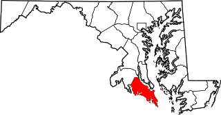
This is a list of the National Register of Historic Places listings in Somerset County, Maryland.

<span class="mw-page-title-main">National Register of Historic Places listings in Washington County, Maryland</span>

This is a list of the National Register of Historic Places listings in Washington County, Maryland.

<span class="mw-page-title-main">National Register of Historic Places listings in Talbot County, Maryland</span>

This is a list of the National Register of Historic Places listings in Talbot County, Maryland.

<span class="mw-page-title-main">National Register of Historic Places listings in Allegany County, Maryland</span>

This is a list of the National Register of Historic Places listings in Allegany County, Maryland.

<span class="mw-page-title-main">National Register of Historic Places listings in Charles County, Maryland</span>

This is a list of the National Register of Historic Places listings in Charles County, Maryland.

<span class="mw-page-title-main">National Register of Historic Places listings in Howard County, Maryland</span>

This is a list of the National Register of Historic Places listings in Howard County, Maryland.

<span class="mw-page-title-main">National Register of Historic Places listings in Kent County, Maryland</span>

This is a list of the National Register of Historic Places listings in Kent County, Maryland.

<span class="mw-page-title-main">National Register of Historic Places listings in St. Mary's County, Maryland</span>

This is a list of the National Register of Historic Places listings in St. Mary's County, Maryland.

<span class="mw-page-title-main">National Register of Historic Places listings in Worcester County, Maryland</span>

This is a list of the National Register of Historic Places listings in Worcester County, Maryland.

<span class="mw-page-title-main">National Register of Historic Places listings in Calvert County, Maryland</span>

This is a list of the National Register of Historic Places listings in Calvert County, Maryland.

<span class="mw-page-title-main">National Register of Historic Places listings in Caroline County, Maryland</span>

This is a list of the National Register of Historic Places listings in Caroline County, Maryland.

<span class="mw-page-title-main">National Register of Historic Places listings in Dorchester County, Maryland</span>

This is a list of the National Register of Historic Places listings in Dorchester County, Maryland.

<span class="mw-page-title-main">National Register of Historic Places listings in Garrett County, Maryland</span>

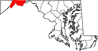
This is a list of the National Register of Historic Places listings in Garrett County, Maryland.

References

  1. The latitude and longitude information provided in this table was derived originally from the National Register Information System, which has been found to be fairly accurate for about 99% of listings. Some locations in this table may have been corrected to current GPS standards.
  2. National Park Service, United States Department of the Interior, "National Register of Historic Places: Weekly List Actions", retrieved March 1, 2024.
  3. Numbers represent an alphabetical ordering by significant words. Various colorings, defined here, differentiate National Historic Landmarks and historic districts from other NRHP buildings, structures, sites or objects.
  4. The eight-digit number below each date is the number assigned to each location in the National Register Information System database, which can be viewed by clicking the number.